Situation Summary
Equatorial Guinea presents a composite security profile characterized by persistent urban crime, porous border controls, and periodic infrastructure disruption, without acute conflict or state collapse. No discrete security incidents have been confirmed in the past 24–48 hours; the threat environment remains at baseline chronic risk rather than acute emergency. The country's global threat ranking reflects low-intensity, manageable hazards for corporate operations, though sub-national variation is significant. Recent health-control measures (21-day Ebola quarantine for arrivals from Uganda/DRC, implemented 18 July) indicate active border management in response to regional disease risk.
Key Developments
No verifiable, time-stamped security or travel-risk incidents meeting incident-level criteria can be confirmed from open sources for 2–3 August 2026. Spanish MFA and international news feeds, local outlets (Journal de Malabo, Guinea24, AfricaPro24), and regional intelligence coverage show no documented riots, armed clashes, major thefts, arrests, or infrastructure failures clearly dated to the past 24–48 hours. The most recent dated external development—Equatorial Guinea–Gabon settlement agreement on the island dispute (28 July 2026)—lies outside the current reporting window and does not represent an acute security shift. Ongoing conditions noted in advisory literature (urban crime in Malabo/Bata, unannounced land border closures in the continental region) reflect chronic rather than emerging risk.
Highest-Risk Areas
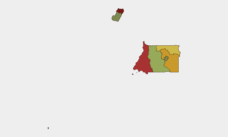
Bioko Norte (risk 85) and Litoral Province (risk 78) dominate the sub-national threat landscape, driven by documented urban crime concentration, port-related smuggling activity, and limited police capacity in Malabo and Bata respectively. Wele-Nzas (72) and Kié-Ntem (68) provinces present elevated risk due to porous borders with Cameroon and Gabon, sporadic closure of crossing points, and limited state presence in remote areas. In contrast, Djibloho (15) and Annobón Province (8) exhibit minimal tracked threat activity, reflecting lower population density and reduced corporate/expatriate presence. Risk concentration in the northern and western corridors reflects operational and criminal activity vectors rather than active conflict.
How GeoBit Would Assist
Security teams managing personnel or assets in Equatorial Guinea should deploy AOI Monitoring & Early Warning on Malabo and Bata urban centers and border crossings in Wele-Nzas/Kié-Ntem to detect emerging unrest, closure announcements, or crime pattern shifts in near-real time. Intel Sweep combined with multi-language OSINT (X, Telegram, local news) and entity extraction on port operators, border agencies, and security services provide continuous baseline awareness and early signal of policy or security changes. Routing & Network Analysis supports contingency planning for personnel movement in provinces with unannounced closures, while Sentinel monitoring of health/diplomatic advisories flags quarantine or visa-control changes affecting operations.
7-Day Outlook
The security environment is forecast to remain stable at current chronic-risk baseline through early August, with no indicators of acute escalation in crime, civil unrest, or border instability. Border-control enforcement and health quarantine procedures are likely to remain in effect pending regional Ebola developments. Duty-of-care teams should maintain standard vigilance in Bioko Norte and Litoral Province urban areas and confirm current border-crossing status before any cross-border movement.
Highest-Risk Areas — Ranked
| # | State / Region | Risk |
|---|---|---|
| 1 | Bioko Norte | 85 |
| 2 | Litoral Province | 78 |
| 3 | Wele-Nzas Province | 72 |
| 4 | Kié-Ntem Province | 68 |
| 5 | Centro Sur Province | 45 |
| 6 | Bioko Sur | 38 |
| 7 | Djibloho | 15 |
| 8 | Annobón Province | 8 |
Sources
Previous Daily Briefs
A new Equatorial Guinea brief is written every day — each with its own risk map and downloadable CSV. Here's the last week; use the calendar to go further back.
📅 Browse every day by calendar →
Highlighted days have a brief. Tap a day for that day's map & analysis, or “csv” for that day's dataset ($5).
Atlas — our AI intelligence desk — emails them this snapshot personally. Nothing else, no list.