Situation Summary
Equatorial Guinea presents a composite security threat profile rated at 5 globally, with no discrete kinetic or civil-unrest events reported in the last 24–48 hours. The country's risk landscape remains dominated by chronic urban crime in major cities, standing border closures on the continental side, and health-related entry restrictions; no new incidents have emerged to alter this baseline. The security environment is stable at the national level but requires sustained attention to localized crime patterns and border-transit friction points.
Key Developments
No new security, conflict, or acute travel-risk incidents have been corroborated in Equatorial Guinea during 2–4 August 2026.
Open-source intelligence monitoring (mainstream news, specialist security feeds, geolocated social media) detected no timestamped reports of shootings, bombings, large demonstrations, arrest operations, or border incidents within this 24–48-hour window. Recent public reporting on Equatorial Guinea has focused on diplomatic moves (Gabon border accord), oil-sector activity, and health policy (Ebola quarantine requirements) rather than new security events.
The continental land borders remain officially closed since 15 December 2025 for an indeterminate period, with frequent unannounced re-openings; no change to closure status was reported in the last 48 hours. A 21-day quarantine for arrivals from Uganda and DRC (decreed 18 July 2026) remains in effect with no reported enforcement complications or public-health emergencies in the last 24 hours. Urban crime in Malabo and Bata (robberies, night-time assaults) continues as a pattern; no specific incidents with 2–4 August attribution appear in corroborated sources.
Highest-Risk Areas
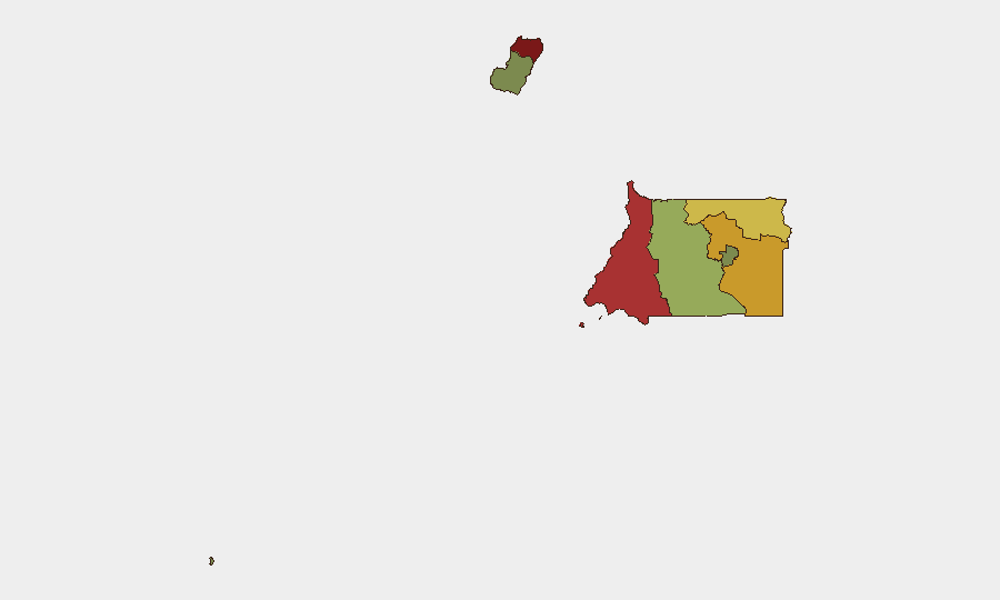
Bioko Norte (risk 85) and Litoral Province (risk 78) account for the country's highest sub-national threat concentrations, driven primarily by urban crime density, informal-settlement vulnerability, and limited law-enforcement capacity in Malabo and Bata respectively. Wele-Nzas Province (72) and Kié-Ntem Province (68) reflect border-friction and cross-border crime dynamics tied to the closed continental frontier; these northern regions experience smuggling, informal commerce disruption, and reduced state presence. Centro Sur, Bioko Sur, and the administrative zones (Djibloho, Annobón) carry substantially lower risk profiles. Corporate and humanitarian personnel should concentrate protective measures and duty-of-care protocols on the two major urban centers and northern border provinces.
How GeoBit Would Assist
Intel Sweep and multi-language OSINT fusion enable continuous monitoring of Malabo, Bata, and border crossings for early warning of new crime clusters, protest activity, or enforcement operations. AOI Monitoring & Early Warning with persistent alerting on Bioko Norte and Litoral Province would flag any emerging kinetic incidents, civil unrest, or infrastructure disruptions within 4–6 hours of occurrence. Network & Actor Analysis applied to smuggling routes and informal-settlement security dynamics in high-risk zones would support route-planning and asset-movement decisions for field teams.
7-Day Outlook
No imminent escalation of security incidents is forecast for 5–11 August 2026. Baseline risks—urban crime, border-transit friction, and Ebola-related quarantine enforcement—are expected to remain stable; border-reopening status should be monitored, as unannounced closures or re-openings historically occur without advance notice. Diplomatic activity and oil-sector developments may influence political stability indirectly, but no acute trigger for security deterioration is apparent in the near term.
Highest-Risk Areas — Ranked
| # | State / Region | Risk |
|---|---|---|
| 1 | Bioko Norte | 85 |
| 2 | Litoral Province | 78 |
| 3 | Wele-Nzas Province | 72 |
| 4 | Kié-Ntem Province | 68 |
| 5 | Centro Sur Province | 45 |
| 6 | Bioko Sur | 38 |
| 7 | Djibloho | 15 |
| 8 | Annobón Province | 8 |
Sources
Previous Daily Briefs
A new Equatorial Guinea brief is written every day — each with its own risk map and downloadable CSV. Here's the last week; use the calendar to go further back.
📅 Browse every day by calendar →
Highlighted days have a brief. Tap a day for that day's map & analysis, or “csv” for that day's dataset ($5).
Atlas — our AI intelligence desk — emails them this snapshot personally. Nothing else, no list.