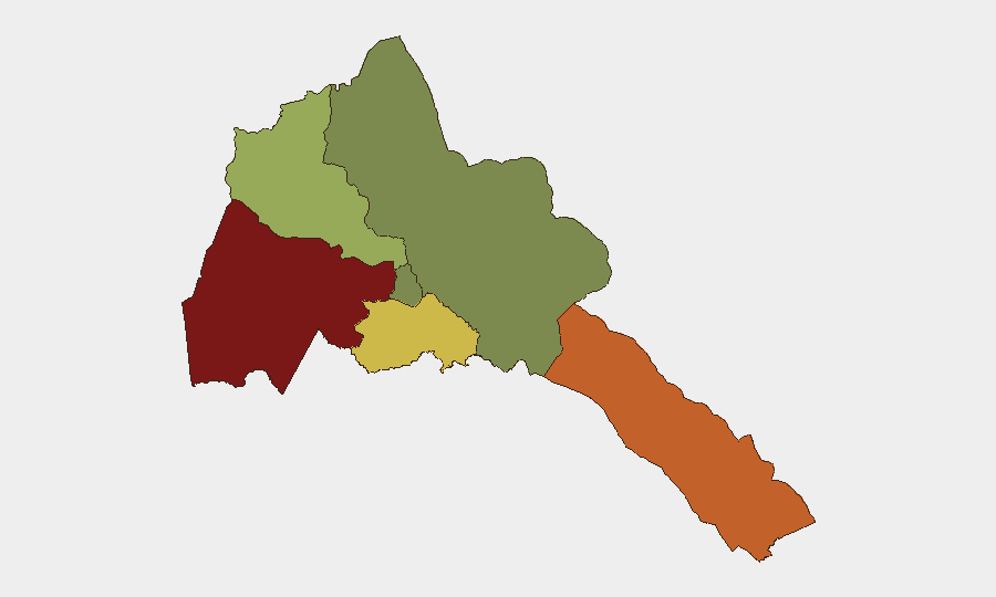
Situation Summary
Eritrea remains stable across most populated areas, with no confirmed security incidents, civil unrest, or infrastructure disruptions reported in the last 24–48 hours. A single unverified "unconventional violence" signal involving Eritrea and Canada was flagged on 24 July but lacks corroborating details on location, nature, or impact. The overall national threat score remains low (18), though significant regional variation exists, with Gash-Barka and the Southern Red Sea Region presenting elevated risk profiles.
Key Developments
- Eritrea–Canada signal (location unspecified) – 24 July 2026
An intelligence platform flagged an unconventional-violence incident involving Eritrea and Canada. No corroborating public reporting, casualty figures, or geographic specifics have been verified; status remains under source review.
- No confirmed domestic security incidents – 24–25 July 2026
Multi-source open-source monitoring (news, social media, broadcast outlets) identified no protests, clashes, bombings, border firefights, infrastructure failures, or civil-unrest events inside Eritrea during this window.
- No new travel advisories or evacuation orders – 24–25 July 2026
No immediate country-wide or region-specific travel warnings tied to current events in Eritrea were issued by major governments or organizations in this period.
Highest-Risk Areas
Gash-Barka (composite risk 92) and the Southern Red Sea Region (75) drive the country's sub-national threat profile, followed by Debub Region (68). These western and southern areas likely reflect sustained risks associated with border dynamics, internal displacement, and limited state capacity rather than acute incidents in the reporting window. Maekel Region (Asmara) and the Northern Red Sea Region remain comparatively lower-risk, reflecting greater security presence and economic activity in the capital and coastal zones.
How GeoBit Would Assist
Security teams with personnel or assets in Eritrea should leverage AOI (Area-of-Interest) Monitoring & Early Warning on Gash-Barka and Southern Red Sea Region to detect emerging civil unrest, movement, or infrastructure disruption before public reporting. Intel Sweep and multi-language OSINT fusion (including X/Twitter, Telegram, and regional broadcast monitoring) will corroborate or clarify the unverified Eritrea–Canada signal and catch subsequent developments. GIS & Spatial Analysis and Routing & Network Analysis enable alternative-route planning around confirmed risk zones and support duty-of-care assessments for staff movement and supply chains.
7-Day Outlook
No immediate escalation is forecast based on current open-source data and the absence of triggering events. The unverified Canada–Eritrea signal should be monitored closely; if corroboration emerges, it may signal diplomatic tension or isolated incidents rather than systemic instability. Baseline risks in Gash-Barka and the Southern Red Sea Region are expected to persist; teams should maintain standard protective posture and heighten situational awareness if operations expand into these areas.
Report Date: 26 July 2026 | Data Recency: 24–25 July 2026 | Confidence: Moderate (limited corroboration; unverified signal under review)
Highest-Risk Areas — Ranked
| # | State / Region | Risk |
|---|---|---|
| 1 | Gash-Barka | 92 |
| 2 | Southern Red Sea Region | 75 |
| 3 | Debub Region | 68 |
| 4 | Anseba | 55 |
| 5 | Maekel Region | 18 |
| 6 | Northen Red Sea Region | 0 |
Sources
Previous Daily Briefs
A new Eritrea brief is written every day — each with its own risk map and downloadable CSV. Here's the last week; use the calendar to go further back.
📅 Browse every day by calendar →
Highlighted days have a brief. Tap a day for that day's map & analysis, or “csv” for that day's dataset ($5).
Atlas — our AI intelligence desk — emails them this snapshot personally. Nothing else, no list.