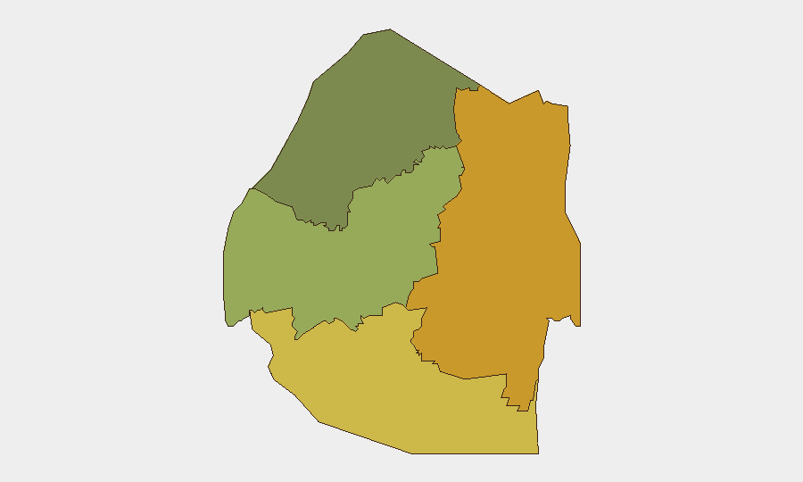
Situation Summary
Eswatini remains a low-threat environment at the national level (composite threat score 9/global rank 124), with no confirmed acute security incidents, civil unrest, or infrastructure disruptions reported in the last 24–48 hours as of 6 August. The country's security posture is stable and predictable, though sub-national risk concentration in the eastern and southern regions warrants targeted monitoring by organizations with assets in those areas. The absence of tracked discrete events reflects a period of relative calm, but persistent vulnerabilities in fire response (noted following the late-July Matsapha incident) and weather-related infrastructure exposure remain operational considerations.
Key Developments
- No confirmed acute incidents, national scope — 6 August 2026 — GeoBit monitoring detected no protests, violence, roadblocks, or acute security events in the last 24–48 hour reporting window.
- Northern Hhohho / Piggs Peak area, weather-related power outages — 5 August 2026 — Hailstorms disrupted power supplies across multiple communities; classified as weather/infrastructure reporting rather than acute security risk, but relevant to contingency planning for operations in the region.
- Matsapha fire-response measures announced — 31 July 2026 (historical context) — Government announced strengthened fire-response protocols following the D-Square Building incident; provides baseline for assessing emergency-service capability in central regions.
Highest-Risk Areas
Lubombo Region (composite risk 72) and Shiselweni Region (risk 68) drive the country's sub-national risk profile, together accounting for the majority of geographic vulnerability. Both regions exhibit persistent exposure to cross-border dynamics, limited infrastructure resilience (evidenced by weather-related disruptions), and constrained emergency-response capacity. Manzini Region (risk 55) represents secondary concern, while Hhohho (risk 35) remains comparatively lower-risk. Organizations with personnel, supply chains, or critical assets in Lubombo and Shiselweni should prioritize localized early-warning systems and contingency routing.
How GeoBit Would Assist
AOI Monitoring & Early Warning provides persistent watch over high-risk districts (Lubombo, Shiselweni) with immediate alerting on protest activity, roadblocks, or infrastructure disruption. OSINT Fusion & Corroboration (X/Twitter, Telegram, radio SIGINT, multi-language search) enables real-time verification of emerging incidents and local sentiment shifts, reducing false-alarm overhead. Routing & Network Analysis supports rapid identification of alternative supply or personnel movement corridors if primary routes through high-risk regions become compromised. Event Feed & Intel Sweep capabilities maintain continuous cross-source monitoring to detect precursor signals (labor unrest, political tension, security-force mobilization) before they escalate to operational impact.
7-Day Outlook
No material change to the current stable threat posture is forecast for the next seven days. Sub-national risks in Lubombo and Shiselweni will remain elevated but localized; monitoring should focus on weather seasonality, cross-border activity, and any labor or political signals originating in neighboring South Africa. Duty-of-care teams should treat the next week as a consolidation period to audit contingency plans for high-risk regions and refresh asset-location inventories.
Highest-Risk Areas — Ranked
| # | State / Region | Risk |
|---|---|---|
| 1 | Lubombo | 72 |
| 2 | Shiselweni | 68 |
| 3 | Manzini Region | 55 |
| 4 | Hhohho Region | 35 |
Sources
Previous Daily Briefs
A new Eswatini brief is written every day — each with its own risk map and downloadable CSV. Here's the last week; use the calendar to go further back.
📅 Browse every day by calendar →
Highlighted days have a brief. Tap a day for that day's map & analysis, or “csv” for that day's dataset ($5).
Atlas — our AI intelligence desk — emails them this snapshot personally. Nothing else, no list.