Situation Summary
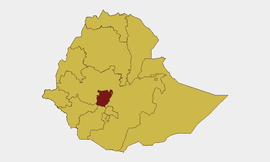
Ethiopia remains the ninth highest-threat country globally (composite score 100) driven primarily by ongoing civil conflict. Central Ethiopia Regional State carries the highest sub-national risk (score 100), with ten additional regions assessed at score 70 each, indicating widespread instability across most of the country. The security environment shows no signs of near-term de-escalation, with recent signals including alleged forced military recruitment in Tigray, cross-border RSF attacks on northern border regions, and concurrent disease outbreaks (Marburg, malaria) and wildfires adding humanitarian pressure.
Key Developments
- Addis Ababa, 28 June 2026 – Ethiopia's National Intelligence and Security Service (NISS) announced deployment of new intelligence-driven security systems at borders and airports to strengthen national security capacity; this represents institutional response to persistent threat environment rather than a new incident per se.
- Tigray Region, 28 June 2026 – Social media reporting cited allegations of forced military recruitment and ongoing security/peace concerns; sourcing remains preliminary and requires corroboration.
- Northern Border Regions, recent – Ethiopia condemned Sudanese RSF (Rapid Support Forces) attacks on border areas; this reflects the spillover dimension of Sudan's conflict into Ethiopian territory.
- Nationwide, 22–28 June 2026 – Ethiopia held its seventh general election; electoral activity proceeded amid documented instability, but the event itself is administrative rather than an acute security incident.
- Multiple Locations, recent – Confirmed wildfire events in Ethiopia (including cross-border incidents with Sudan) and two separate Marburg virus disease confirmations add environmental and health-sector stress; malaria cases also reported.
- Nigeria connection, 28 June 2026 – A kidnapping/hostage incident involving a Nigerian national was recorded; geographic connection to Ethiopia operations unclear from available signals.
Note: The past 24–48 hours show limited confirmed acute incidents in open-source reporting. The NISS border-security announcement and the Tigray recruitment allegations are the most concrete near-term signals; disease and wildfire events represent secondary stressors on security infrastructure.
Highest-Risk Areas
Central Ethiopia Regional State stands alone at risk score 100, making it the primary focus for corporate operations. The remaining eleven regions all score 70, indicating that high-risk conditions are nearly pan-national: Tigray, Amhara, Afar, Benishangul-Gumuz, Somali, Gambela, South West Ethiopia Peoples, Addis Ababa, South Ethiopia Regional State, Oromia, and Sidama. This distribution reflects the structural nature of the conflict—no region is reliably safe—and suggests that centralized operations in Addis Ababa face the same elevated risk as field locations, albeit with different threat vectors (urban instability, intelligence operations, restricted movement).
How GeoBit Would Assist
Security teams managing Ethiopia operations should employ AOI Monitoring & Early Warning to track Central Ethiopia and high-risk northern regions (Tigray, Amhara, Afar) for incident escalation. Intel Sweep and multi-language OSINT (including X/Telegram monitoring and local-language social media) would provide early warning of military recruitment drives, forced displacement, or sudden armed movement. GIS & Spatial Analysis linked to satellite imagery can assess wildfire proximity to transport routes and critical facilities, while Network & Actor Analysis clarifies the organizational actors (militia, state forces, armed groups) operating in areas where personnel or assets are positioned.
7-Day Outlook
No major political or military inflection points are signaled for the immediate 7-day window. The newly announced NISS security systems may increase checkpoint activity and documentation requirements at borders and airports, creating operational friction but not imminent threat escalation. Disease outbreaks and wildfires will likely continue as secondary stressors, particularly affecting supply chains and mobility in rural areas; sustained monitoring of health and environmental conditions is warranted for duty-of-care planning.
Highest-Risk Areas — Ranked
| # | State / Region | Risk |
|---|---|---|
| 1 | Central Ethiopia Regional State | 100 |
| 2 | Tigray | 70 |
| 3 | Amhara Region | 70 |
| 4 | Afar Region | 70 |
| 5 | Benishangul-Gumuz Region | 70 |
| 6 | Somali Region | 70 |
| 7 | Gambela Region | 70 |
| 8 | South West Ethiopia Peoples | 70 |
| 9 | Addis Ababa | 70 |
| 10 | South Ethiopia Regional State | 70 |
| 11 | Oromia Region | 70 |
| 12 | Sidama | 70 |
Sources
Previous Daily Briefs
A new Ethiopia brief is written every day — each with its own risk map and downloadable CSV. Here's the last week; use the calendar to go further back.
📅 Browse every day by calendar →
Highlighted days have a brief. Tap a day for that day's map & analysis, or “csv” for that day's dataset ($5).