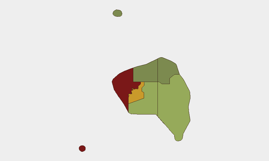
Situation Summary
Fiji remains a low-threat environment globally (rank #64, composite score 28) with no tracked active conflict or organized violence campaigns. The country faces dispersed risks concentrated in the Western and Central divisions, driven by petty crime, maritime hazards, and isolated violent incidents rather than systemic instability. Current operational concerns center on a maritime search-and-rescue operation and a localized criminal investigation; overall security posture for corporate assets and personnel remains stable.
Key Developments
- Lau Group (maritime, 6 Aug 2026): A fiberglass vessel carrying six healthcare workers en route between Namuka and Fulaga failed to arrive; JRCC Fiji and Maritime Safety Authority Fiji launched active search-and-rescue operations. Vessel suffered engine failure; strong wind warnings were in effect at time of incident. Status of crew remains unconfirmed as of reporting.
- Tama, Southern Viti Levu (27 Jul–5 Aug 2026): Police arrested a 29-year-old male in connection with the death of a 12-year-old boy discovered near his home. Incident classified as violence against civilians; investigation ongoing. No indication of broader criminal network or gang activity.
- Mariners' advisory: Fiji authorities issued strong wind warnings affecting outer maritime zones; vessels operating in Lau Group and similar waters should observe precautionary routing.
Highest-Risk Areas
Western Division (risk 85) and Central Division (risk 72) account for the majority of Fiji's internal threat surface, driven by property crime, petty theft, and occasional violent crime in urban and peri-urban centers (primarily Suva and western coastal towns). Eastern Division (risk 45) and Northern Division (risk 38) carry moderate concern; Rotuma (risk 12) remains the lowest-risk region. Risk elevation in the west and center reflects population density, informal settlements, and limited police capacity rather than political instability or organized criminal infrastructure. Maritime hazards—including vessel casualties and search-and-rescue operations—cut across all coastal regions and should factor into duty-of-care protocols for any sea-based operations or personnel transit.
How GeoBit Would Assist
Security teams with personnel or assets in Fiji should deploy AOI Monitoring & Early Warning on Western and Central division hotspots (Suva, Ba, Lautoka) to detect emerging crime patterns or civil unrest in real time. Maritime & Aviation tracking combined with Environmental & Health intelligence would provide advance notice of weather hazards and maritime incidents affecting personnel in transit or operating offshore. OSINT fusion (X/Twitter, local news, police bulletins) enables rapid corroboration of incident reports and early classification of threats to duty-of-care decision-making.
7-Day Outlook
No indicators suggest imminent escalation in Fiji's security environment. The maritime incident will likely dominate regional attention through weekend recovery efforts; personnel traveling by sea should confirm vessel seaworthiness and crew credentials. Petty crime and isolated violent incidents will persist in Western and Central zones at baseline rates; standard corporate security hygiene (access control, escort protocols, awareness training) remains the primary mitigation. Monitor search-and-rescue outcome and any secondary weather impacts through 10 August.
Highest-Risk Areas — Ranked
| # | State / Region | Risk |
|---|---|---|
| 1 | Western | 85 |
| 2 | Central | 72 |
| 3 | Eastern | 45 |
| 4 | Northern | 38 |
| 5 | Rotuma | 12 |
Sources
Previous Daily Briefs
A new Fiji brief is written every day — each with its own risk map and downloadable CSV. Here's the last week; use the calendar to go further back.
📅 Browse every day by calendar →
Highlighted days have a brief. Tap a day for that day's map & analysis, or “csv” for that day's dataset ($5).
Atlas — our AI intelligence desk — emails them this snapshot personally. Nothing else, no list.