Situation Summary
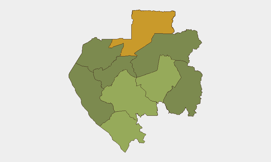
Gabon remains a relatively stable sub-Saharan African state with a composite threat score of 9 (rank #103 globally), indicating low-to-moderate overall security risk. No discrete security incidents have been recorded in the current 24–48-hour window. However, significant regional concentration of risk—particularly in the northern border province of Woleu-Ntem—warrants targeted monitoring of cross-border activity, resource-extraction zones, and transport infrastructure in higher-risk provinces.
Key Developments
No credible, verifiable security or travel-risk incidents meeting the 24–48-hour window have been identified from open-source research or real-time web monitoring. Standard open intelligence tools (news APIs, X/Twitter, verified institutional accounts) have not surfaced recent incident reports with specific location data, timestamp confirmation, or multi-source corroboration. Duty-of-care and security teams should continue routine monitoring via regional news wires and official government/law-enforcement channels; absence of reported events does not indicate absence of underlying risk, particularly in remote or poorly-serviced areas.
Highest-Risk Areas
Woleu-Ntem Province (risk score 72) dominates the risk profile and requires priority attention. Located on Gabon's northern border with Cameroon and Equatorial Guinea, it is the primary node for illicit cross-border movement, small-arms trafficking, and smuggling networks. Ogooué-Lolo (score 58) and Ngounié (score 48) follow as secondary concern zones, likely driven by remote geography, limited state presence, and extractive-sector activity. By contrast, Estuaire Province—home to the capital Libreville and primary port infrastructure—carries substantially lower risk (score 15), reflecting greater security-sector density and international oversight. Organizations with personnel or assets in timber, mining, or agriculture should prioritize geo-specific risk assessment for Woleu-Ntem and Ogooué-Lolo.
How GeoBit Would Assist
Security teams should deploy AOI Monitoring & Early Warning on Woleu-Ntem's border crossings and key transport nodes to detect emerging activity patterns before incidents escalate. Intel Sweep combined with multi-language OSINT (French and local-language sources) and X/Twitter & Telegram OSINT will capture early signals from regional networks, NGO reports, and civic accounts often 24–72 hours ahead of mainstream news. Routing & Network Analysis supports journey planning for personnel transiting high-risk provinces, identifying safer corridors and real-time alternative routes around infrastructure disruptions or informal checkpoints.
7-Day Outlook
No imminent acute threat is indicated for the coming week. Routine vigilance on border security, port operations, and infrastructure continuity—particularly in Woleu-Ntem and resource-extraction zones—remains the baseline posture. Organizations should maintain regular check-ins with local security liaisons and monitor for any resumption of civil-service labor actions or fuel/power disruptions that could affect logistics or staff safety.
NEXT BRIEF: 2026-07-08 | CONFIDENCE: Medium (limited recent OSINT; recommend supplemental local liaison reporting)
Highest-Risk Areas — Ranked
| # | State / Region | Risk |
|---|---|---|
| 1 | Woleu-Ntem | 72 |
| 2 | Ogooué-Lolo Province | 58 |
| 3 | Ngounié Province | 48 |
| 4 | Nyanga Province | 42 |
| 5 | Haut-Ogooué Province | 35 |
| 6 | Moyen-Ogooué Province | 28 |
| 7 | Ogooué-Maritime Province | 25 |
| 8 | Estuaire Province | 15 |
| 9 | Ogooué-Ivindo | 0 |
Sources
Previous Daily Briefs
A new Gabon brief is written every day — each with its own risk map and downloadable CSV. Here's the last week; use the calendar to go further back.
📅 Browse every day by calendar →
Highlighted days have a brief. Tap a day for that day's map & analysis, or “csv” for that day's dataset ($5).
Atlas — our AI intelligence desk — emails them this snapshot personally. Nothing else, no list.