Situation Summary
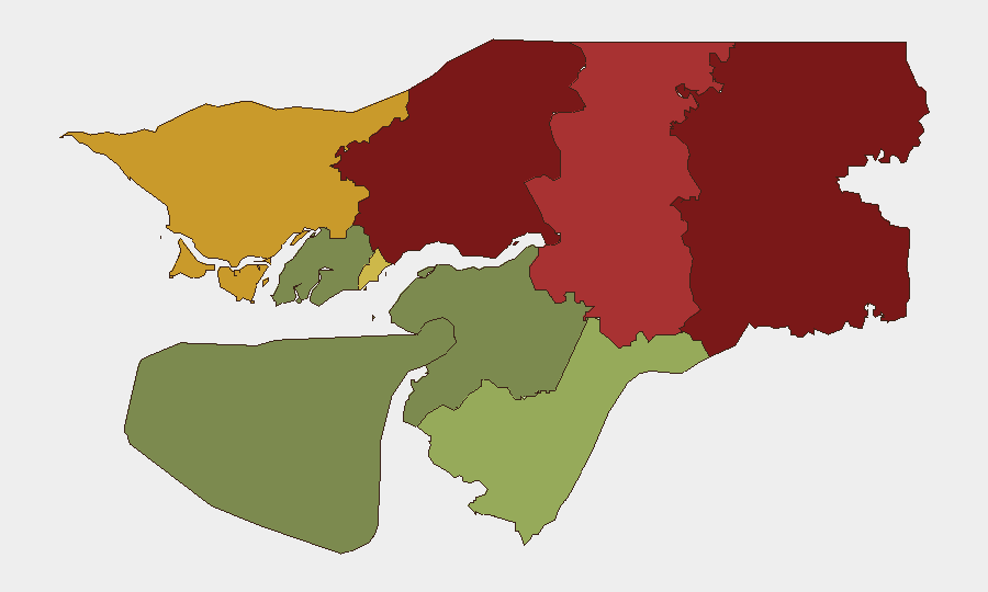
Guinea-Bissau remains at composite threat rank #126 globally with no tracked acute security incidents in the last 24–48 hours. The country is currently navigating a post-coup political transition, with ECOWAS mediation efforts underway as of 6–7 August to facilitate dialogue and stabilization. Security risk remains highly localized, concentrated in the northeastern and eastern border regions (Gabu, Oio, and Bafatá), while the capital and southern zones show substantially lower threat profiles.
Key Developments
- Bissau, 6–7 August — Senegal initiated ECOWAS-facilitated mediation efforts to address the post-coup political crisis; no security incidents or civil unrest reported during the mediation process.
- Nationwide, 6–8 August — GeoBit monitoring confirmed no verified armed conflict, major crime incidents, or destabilization events during the 24–48 hour window.
- Bissau, 3 August — Nigerian Army completed routine troop rotation at ECOWAS Stabilization Support Mission headquarters with no disruptions or violence reported.
- Maritime — A Guinea-Bissau-flagged vessel sustained casualties (1 killed, 3 injured) in a Russian strike on Black Sea commercial shipping on 8 August; incident occurred outside Guinea-Bissau territory but reflects exposure of national maritime assets to external conflict zones.
Highest-Risk Areas
Gabu Region (risk 92) and Oio Region (risk 85) drive the country's sub-national threat profile, with both northeastern border zones showing elevated risk linked to cross-border trafficking, weak state authority, and historical instability. Bafatá Region (risk 78) extends this band of concern southeastward along border areas. These three regions represent approximately 55 percent of Guinea-Bissau's total risk concentration; risk drops significantly in Tombali and southern zones, and reaches minimal levels in Bolama (risk 15). The risk gradient reflects geographic proximity to Senegal and Mali, porous borders, and limited government presence rather than acute current violence.
How GeoBit Would Assist
Security teams operating in or accountable for Guinea-Bissau personnel or assets should deploy AOI Monitoring & Early Warning focused on Gabu, Oio, and Bafatá regions to detect rapid escalation in cross-border activity, trafficking, or armed group movement. Intel Sweep and multi-language OSINT fusion (X/Telegram, local news) provide real-time visibility into political developments and security incidents below the headline threshold. Maritime tracking is relevant given the country's flag-of-convenience registry and exposure of vessels to regional conflicts; Routing & Network Analysis supports safe-passage planning for overland movement between Bissau and other hubs.
7-Day Outlook
The political mediation process is expected to remain the dominant near-term variable; successful facilitation could stabilize the trajectory, while breakdown would increase risk of renewed civil tension. Border-zone activity is unlikely to change materially in the next week absent external shocks. No escalation signals are evident in current reporting.
Highest-Risk Areas — Ranked
| # | State / Region | Risk |
|---|---|---|
| 1 | Gabu Region | 92 |
| 2 | Oio Region | 85 |
| 3 | Bafatá Region | 78 |
| 4 | Cacheu Region | 72 |
| 5 | Bissau Autonomous Sector | 68 |
| 6 | Tombali Region | 45 |
| 7 | Quinara Region | 38 |
| 8 | Biombo Region | 32 |
| 9 | Bolama Region | 15 |
Sources
Previous Daily Briefs
A new Guinea-Bissau brief is written every day — each with its own risk map and downloadable CSV. Here's the last week; use the calendar to go further back.
📅 Browse every day by calendar →
Highlighted days have a brief. Tap a day for that day's map & analysis, or “csv” for that day's dataset ($5).
Atlas — our AI intelligence desk — emails them this snapshot personally. Nothing else, no list.