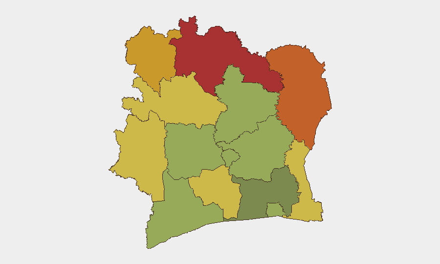
Situation Summary
Ivory Coast remains a moderate-risk environment (global rank #52) with a composite threat score of 32, driven primarily by latent terrorism in the northeastern border zone and elevated crime in major urban centers. No major security incidents have been verified in the last 24–48 hours; the security posture is characterized by persistent structural risks rather than acute escalation. The northern frontier areas adjacent to Mali and Burkina Faso continue to present the highest hazard profile, while Abidjan and southern commercial zones maintain manageable but significant violent-crime exposure.
Key Developments
No verified security incidents meeting multi-source confirmation criteria have been reported in Ivory Coast during 13–15 July 2026.
Open-source monitoring and recent X/Twitter intelligence do not show any clearly timestamped armed violence, civil unrest, infrastructure disruption, or personnel-security events in the last 24–48 hours that rise to briefing threshold. Regional advisories from Germany and Australia continue to reference ongoing terrorism and crime risk, but these are structural assessments rather than responses to new incidents. Intelligence services and wire agencies have not reported fresh kidnappings, militant attacks, or major protests in the specified window.
*Background context (for reference):* Reported but unconfirmed militant assaults on security positions in the Kafolo border sector occurred on 9 July 2026 (6 days prior); community protests against insecurity followed. Flooding has caused cumulative casualties (59+ deaths since May) in Abidjan and other regions, with ongoing risk particularly in Attécoubé district. These represent medium-term threat drivers, not acute developments in the last two days.
Highest-Risk Areas
The northern frontier districts—Savanes, Zanzan, Denguélé, and Comoé—collectively drive Ivory Coast's threat profile, with composite risk scores ranging from 78 to 70. All four border Mali and Burkina Faso, where transnational militant cells operate and kidnapping networks maintain active presence. The Montagnes and Woroba districts (risk 68 and 65 respectively) extend this risk corridor southwestward. By contrast, Abidjan (risk 45) and the southern Lacs, Sassandra-Marahoué, and Bas-Sassandra districts present lower but still material risk from armed robbery, gang violence, and organized crime rather than terrorism.
How GeoBit Would Assist
Security teams should deploy AOI Monitoring & Early Warning on Kafolo, Bouna, and Comoé National Park sectors to detect militant activity or cross-border movements ahead of public reporting. Intel Sweep and OSINT fusion (X/Twitter, Telegram, local radio SIGINT) provide real-time alerting on kidnap threats, roadblocks, and community unrest in border zones. GIS & Spatial Analysis combined with Routing & Network Analysis supports safe-passage planning for personnel traveling between Abidjan and northern or western operations. Satellite & Imagery analysis tracks infrastructure degradation and displacement camps that indicate emerging instability.
7-Day Outlook
No acute trigger is visible in the next 7 days; the security environment is expected to remain broadly stable at current baseline risk levels. Seasonal rains will continue to affect road conditions and flood risk in Abidjan and low-lying areas. Northern border volatility remains the primary driver of change; any cross-border militant incursion or kidnapping in the Kafolo–Bouna corridor would warrant rapid escalation of field-level security postures.
Highest-Risk Areas — Ranked
| # | State / Region | Risk |
|---|---|---|
| 1 | Savanes District | 78 |
| 2 | Zanzan District | 75 |
| 3 | Denguélé District | 72 |
| 4 | Comoé District | 70 |
| 5 | Montagnes District | 68 |
| 6 | Woroba District | 65 |
| 7 | Gôh-Djiboua District | 60 |
| 8 | Sassandra-Marahoué District | 58 |
| 9 | Vallée du Bandama District | 55 |
| 10 | Bas-Sassandra District | 52 |
| 11 | Lacs District | 48 |
| 12 | Abidjan | 45 |
Sources
Previous Daily Briefs
A new Ivory Coast brief is written every day — each with its own risk map and downloadable CSV. Here's the last week; use the calendar to go further back.
📅 Browse every day by calendar →
Highlighted days have a brief. Tap a day for that day's map & analysis, or “csv” for that day's dataset ($5).
Atlas — our AI intelligence desk — emails them this snapshot personally. Nothing else, no list.