Situation Summary
Lebanon is experiencing intense military conflict between Israel and Hezbollah, marked by a declared ceasefire as of 19 June 2026 (16:00 local time) that has seen only partial implementation on the ground. Airstrikes and ground combat continue in southern and eastern regions, with 47–65+ fatalities reported over the past 48 hours and significant civilian casualties in residential areas. The security environment remains volatile, with escalation risk high and essential services (airports, roads, utilities) subject to disruption. Lebanon ranks #11 globally in composite threat score, driven primarily by military strikes and cross-border armed engagement.
Key Developments
- Nabatieh and surrounding villages (Nabatieh Governorate), evening 20 June 2026: Multiple Israeli airstrikes struck residential areas in Nabatieh, Harouf, Habbous, and al-Dweir, killing 16–18 civilians, including children, and injuring dozens; structural damage and reports of people trapped under rubble documented by international media and Civil Defense.
- Southern Lebanon villages (Nabatieh Governorate), overnight 19–20 June 2026: IDF conducted airstrikes on approximately 80–150 targets described as Hezbollah sites, resulting in at least 47 fatalities and 97 injuries in one of the heaviest bombardment phases reported.
- Beqaa Valley, eastern Lebanon, morning/early afternoon 20 June 2026: IDF airstrikes targeted two alleged Hezbollah command centers; additional casualties and infrastructure damage reported but casualty figures not yet fully confirmed.
- Southern Lebanon cross-border sector, late 19–early 20 June 2026: Hezbollah claimed ambush of Israeli unit using anti-tank guided missiles, rockets, and artillery; Israel confirmed four soldiers killed, including a battalion commander.
- Multiple southern Lebanon front-line areas, night 19–20 June 2026: Hezbollah launched dozens of rockets and projectiles toward Israeli positions; exchanges of fire preceded and followed the ceasefire announcement.
- Countrywide ceasefire declaration, Friday 19 June 2026, 16:00 local time: U.S.-brokered "immediate ceasefire" confirmed by IDF and Lebanese authorities; however, Israeli strikes reported continuing in southern and eastern Lebanon after the stated start time, indicating only partial ground compliance.
- Southern and eastern Lebanon, travel advisory update through 20 June 2026: Foreign governments (including Australia) maintain "Do not travel" ratings; security volatility, airstrikes, and infrastructure risk remain acute.
Highest-Risk Areas
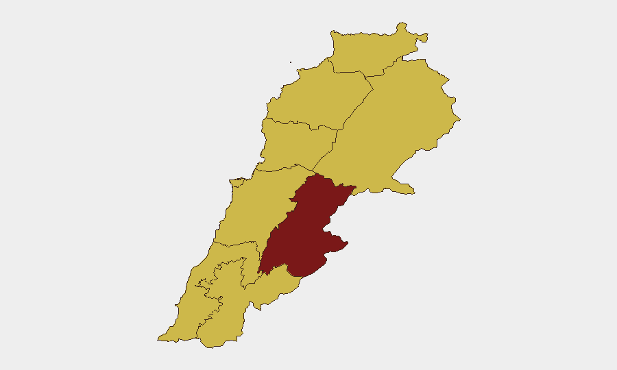
Beqaa Governorate (risk score 92.7) and South Governorate (70.7) dominate the threat landscape, driven by sustained IDF airstrikes on alleged Hezbollah military infrastructure and the concentration of cross-border ground combat. Beirut Governorate (68.3) and Mount Lebanon (67.4) face secondary but significant risk from potential escalation spillover and airspace disruption. Nabatieh Governorate (66.3), though ranking fifth, has suffered the highest civilian impact in the past 48 hours and remains under direct strike pressure.
How GeoBit Would Assist
Security teams should deploy AOI Monitoring & Early Warning on Beqaa Valley and South Governorate to track airstrikes, command-center activity, and ceasefire compliance in real time. Conflict & Military battle mapping and force structure analysis enable tracking of IDF and Hezbollah operational posture and escalation signals. Routing & Network Analysis supports alternative journey planning for personnel and supply chains given ongoing airspace and road closures.
7-Day Outlook
The ceasefire remains fragile and partially implemented; Israeli operations are continuing selectively, and Hezbollah has not yet fully ceased fire. Escalation risk remains elevated if either party interprets compliance failures as provocation. Movement of personnel or assets through southern and eastern Lebanon should be suspended pending clear stabilization signals over 48+ hours.
Highest-Risk Areas — Ranked
| # | State / Region | Risk |
|---|---|---|
| 1 | Beqaa Governorate | 92.7 |
| 2 | South Governorate | 70.7 |
| 3 | Beirut Governorate | 68.3 |
| 4 | Mount Lebanon Governorate | 67.4 |
| 5 | Nabatieh Governorate | 66.3 |
| 6 | Keserwan-Jbeil Governorate | 65.4 |
| 7 | Akkar Governorate | 63.3 |
| 8 | North Governorate | 62.7 |
| 9 | Baalbek-Hermel Governorate | 62.7 |
Sources
Previous Daily Briefs
A new Lebanon brief is written every day — each with its own risk map and downloadable CSV. Here's the last week; use the calendar to go further back.
📅 Browse every day by calendar →
Highlighted days have a brief. Tap a day for that day's map & analysis, or “csv” for that day's dataset ($5).