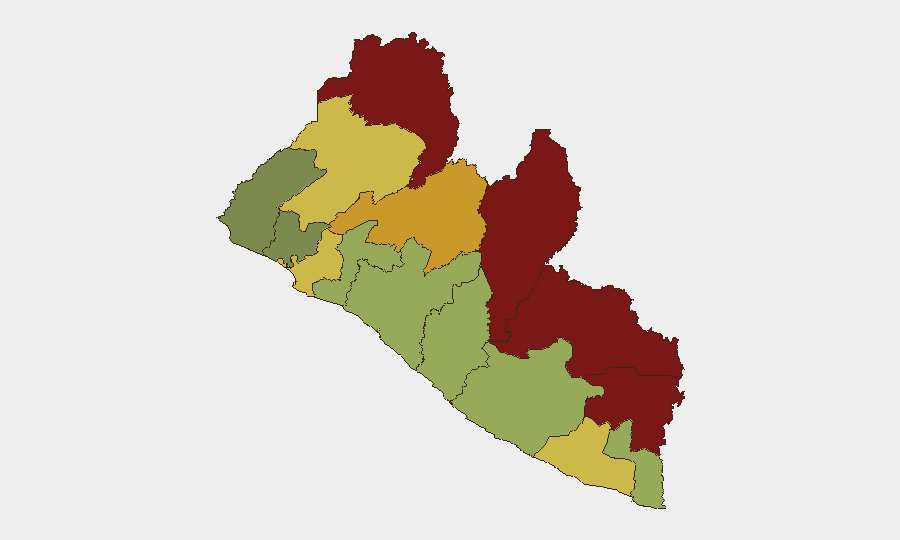
Situation Summary
Liberia remains classified at mid-tier global threat (composite score 7) with no verified security incidents, civil unrest, armed clashes, or acute travel disruptions reported in the past 24–48 hours (August 3–5, 2026). Persistent structural instability in northeastern and east-central counties—particularly Nimba, Lofa, and Grand Gedeh—continues to elevate underlying risk, though no current event activity signals an imminent deterioration. The security environment is characterized by endemic petty crime and armed robbery in urban centers, combined with localized resource-competition tensions in remote border zones, but the trajectory remains static absent new incident triggers.
Key Developments
- Nationwide (Aug 3–5, 2026): No verified security incidents, conflict events, civil unrest, violence, or armed clashes reported across any locality during the 24–48-hour window.
- Monrovia and urban centers (general): Persistent baseline risk of petty crime, armed robbery, and nighttime violence remains unchanged; Canadian travel advisory continues to recommend high caution but reports no new spike or specific incident in the current period.
- Nimba, Lofa, Grand Gedeh Counties (ongoing structural): No acute event activity recorded in the past 48 hours; however, these zones retain the highest composite risk scores (92, 88, and 85 respectively) due to historical instability, cross-border illicit activity, and resource tensions—a chronic condition rather than an active crisis.
- Infrastructure and services (nationwide): No reported disruptions to transport, utilities, communications, or humanitarian access in the current reporting window.
- Political and administrative (general): No civil-unrest, protest, or political-instability events documented in the past 24–48 hours.
Highest-Risk Areas
Nimba County (risk 92) and Lofa County (risk 88) dominate the risk profile, driven by historical armed-group activity, porous borders with Guinea and Sierra Leone facilitating cross-border illicit flows, and competition for natural resources and mining zones. Grand Gedeh, River Gee, and Bong Counties (85, 83, and 72 respectively) share similar northeastern and east-central positions with limited state presence, weak rule of law, and persistent community-level tensions. By contrast, Montserrado County (64)—which includes Monrovia—carries lower sub-national ranking despite concentrated urban crime; risk is diffuse petty and armed crime rather than organized conflict. The eastern counties' elevated scores reflect ungoverned space and weak institutional capacity, not current flashpoint incidents.
How GeoBit Would Assist
Corporate security and duty-of-care teams should deploy Area-of-Interest Monitoring & Early Warning on Nimba, Lofa, and Grand Gedeh Counties to detect emerging flash-point activity in real time, paired with OSINT Fusion & Corroboration across local news, radio SIGINT, and social-media feeds to catch nascent unrest before mainstream reports. Routing & Network Analysis and GIS & Spatial Analysis would support alternative travel planning and safe-movement corridors for personnel transiting high-risk zones. Cross-referenced Conflict & Military intelligence on armed-group positioning and Economic & Trade monitoring of illicit resource flows would contextualize longer-term instability drivers.
7-Day Outlook
No acute triggers or scheduled events are currently visible that would elevate Liberia's threat posture in the near term. Baseline risks—petty crime in Monrovia, structural instability in the northeast—are expected to persist. The absence of incident activity in the current window should not be mistaken for reduced underlying vulnerability; corporate security teams should maintain standard protective measures and continue monitoring for any new event signals, particularly in Nimba and Lofa Counties.
Highest-Risk Areas — Ranked
| # | State / Region | Risk |
|---|---|---|
| 1 | Nimba County | 92 |
| 2 | Lofa County | 88 |
| 3 | Grand Gedeh County | 85 |
| 4 | River Gee County | 83 |
| 5 | Bong County | 72 |
| 6 | Gbarpolu County | 68 |
| 7 | Grand Kru County | 65 |
| 8 | Montserrado County | 64 |
| 9 | Rivercess County | 58 |
| 10 | Sinoe County | 55 |
| 11 | Margibi County | 52 |
| 12 | Grand Bassa County | 48 |
Sources
- geobit.ai
- smartnewsliberia.com
- thenewdawnliberia.com
- thenewsnewspaperonline.com
- fpa.news
- euronews.com
- micat.gov.lr
- smartnewsliberia.com
- thenewsnewspaperonline.com
- thenewsnewspaperonline.com
- lina.micat.gov.lr
- liberianinvestigator.com
- instagram.com
- thenewsnewspaperonline.com
- liberianinvestigator.com
- thenewdawnliberia.com
- reuters.com
- knewsonline.com
Previous Daily Briefs
A new Liberia brief is written every day — each with its own risk map and downloadable CSV. Here's the last week; use the calendar to go further back.
📅 Browse every day by calendar →
Highlighted days have a brief. Tap a day for that day's map & analysis, or “csv” for that day's dataset ($5).
Atlas — our AI intelligence desk — emails them this snapshot personally. Nothing else, no list.