Situation Summary
Moldova remains a low-threat country globally (#155 composite rank) but faces acute, localized security pressures along its eastern and southern borders due to spillover from the Ukraine conflict. Overnight 19–20 August, Russian drone and missile strikes on Ukraine resulted in at least one airspace violation over Gagauzia and related incidents near the Danube border crossing points. The pattern of cross-border incursions—now recurring weekly since mid-August—indicates elevated risk of unintended escalation, debris strikes, or further violations, particularly in southern and eastern administrative divisions.
Key Developments
- Etulia, Gagauzia (20 Aug, ~03:16–03:22): Moldova's National Army detected an unauthorized Russian Shahed-136/Geran-2 drone entering airspace from Ukraine near Kotlovyna, transiting toward Etulia for approximately six minutes before exiting. No casualties or damage reported, but Foreign Ministry condemned the violation as a serious threat to sovereignty.
- Giurgiulești area, Cahul district (20 Aug, ~03:45 and ongoing): Two drone-related incidents reported near the Moldova–Ukraine border; Ministry of Internal Affairs attributed events to spillover from Russian attacks on Ukrainian port infrastructure at Reni, ~10 km north. Border and police forces deployed; no injuries.
- Nationwide airspace (19–20 Aug overnight): During a large-scale Russian missile and drone offensive against Ukraine, at least one drone crossed Moldovan airspace, monitored for several minutes before returning to Ukraine. Foreign Ministry reiterated warnings that repeated violations pose direct risk to critical infrastructure and civilian populations.
- Chișinău, Great National Assembly Square (19 Aug, 09:00–11:30): Education sector unions (FPO/FSEȘ) and National Confederation of Trade Unions held a formally organized daytime protest over education worker salary increases. Described as peaceful but caused localized traffic disruption around central government areas.
- Talmaza, Ștefan Vodă district (context: incident 17–18 Aug, discussion ongoing through 20 Aug): Authorities continued investigation and public commentary on an unidentified aerial object that entered airspace on the Cuciurgan–Tiraspol axis, exploded in a field ~3 km from Talmaza, and ignited vegetation fires. Ongoing alert activity underscores heightened investigative presence in the southeast.
Highest-Risk Areas
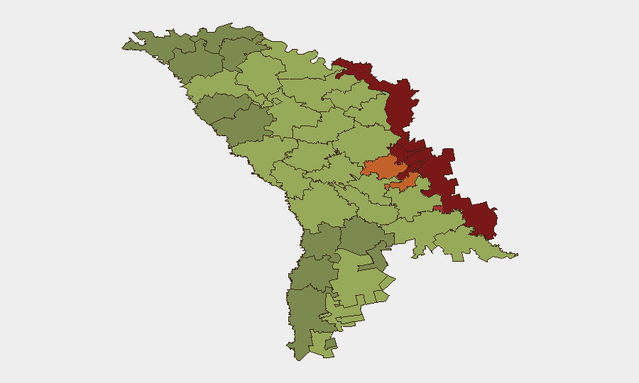
The Left Bank of the Dniester (risk 85), Dubăsari (82), and Bender (79) dominate sub-national rankings due to proximity to contested territory, Russian military presence, and limited state control. Southern border districts—Gagauzia (54), Căușeni (53), and Ștefan Vodă (51)—face acute spillover risk from Ukraine conflict airspace violations and cross-border drone/debris strikes. Chișinău (49), though ranked lower, remains operationally significant for government functions and diplomatic activity; localized protest activity and traffic disruption warrant monitoring of central administrative zones.
How GeoBit Would Assist
Security and risk teams should deploy AOI Monitoring & Early Warning on Gagauzia, Cahul, and Ștefan Vodă districts to detect and alert on drone or aerial incursions in real time. Conflict & Military tracking (force structure, weapons-capability, battle mapping) combined with Aviation tracking would provide early visibility into Ukrainian and Russian operational tempo changes that drive spillover risk. Routing & Network Analysis supports alternative journey planning for personnel and asset movements near border crossing points (Giurgiulești, Reni axis) affected by airspace closures or military activity.
7-Day Outlook
Russian aerial operations against Ukraine are forecast to remain intense through late August, sustaining a baseline weekly risk of airspace violations and debris spillover into Moldovan territory. No direct military threat to Moldova is assessed, but cumulative cross-border incidents increase probability of accidental civilian harm, infrastructure damage, or transport disruption in southern and eastern border zones. Authorities will likely maintain heightened airspace monitoring and border security postures.
Highest-Risk Areas — Ranked
| # | State / Region | Risk |
|---|---|---|
| 1 | Administrative-Territorial Units of the Left Bank of the Dniester | 85 |
| 2 | Dubăsari | 82 |
| 3 | Bender | 79 |
| 4 | Criuleni | 75 |
| 5 | Rezina | 58 |
| 6 | Taraclia | 55 |
| 7 | Gagauzia | 54 |
| 8 | Căușeni | 53 |
| 9 | Soroca | 52 |
| 10 | Ștefan Vodă | 51 |
| 11 | Orhei | 50 |
| 12 | Chișinău | 49 |
Sources
Previous Daily Briefs
A new Moldova brief is written every day — each with its own risk map and downloadable CSV. Here's the last week; use the calendar to go further back.
- August 18, 2026
- August 15, 2026
- August 13, 2026
- August 11, 2026
- August 9, 2026
- August 7, 2026
- August 5, 2026
📅 Browse every day by calendar →
Highlighted days have a brief. Tap a day for that day's map & analysis, or “csv” for that day's dataset ($5).
Atlas — our AI intelligence desk — emails them this snapshot personally. Nothing else, no list.