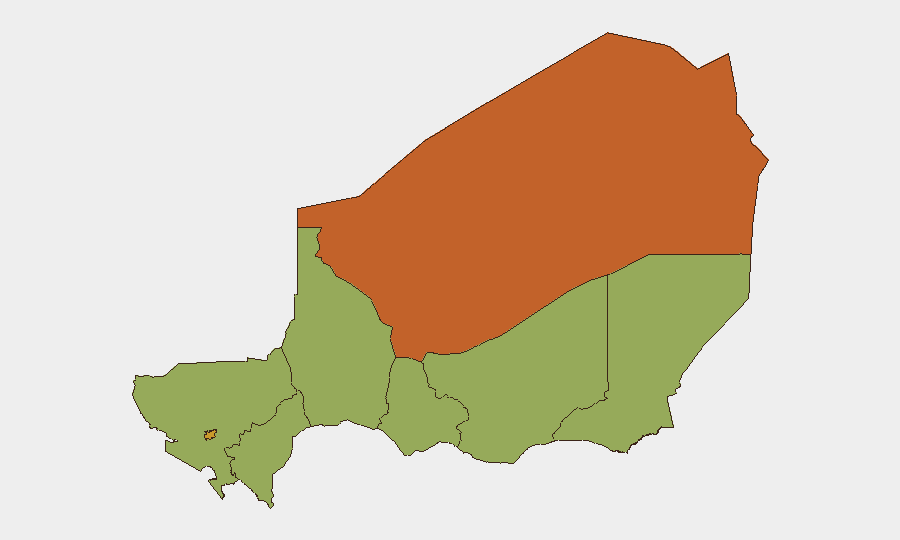
Situation Summary
Niger remains in the middle tier of global security concerns (rank 25, composite score 63) with 17 tracked events in the current monitoring cycle. The country faces a fragmented threat environment spanning cross-border militant activity, inter-state tensions with Nigeria and Benin, and domestic resource disputes. The capital Niamey and northern Agadez Region carry substantially elevated risk profiles (71.6 and 74 respectively), while southern and central regions report moderate baseline threat levels.
Key Developments
- 2026-06-23 · Niamey/National · Conventional Military Force involving Nigeria. Unconfirmed reports of Nigerian military movement or posturing; context suggests escalation of bilateral friction documented in earlier public statements and threats (2026-06-22).
- 2026-06-23 · National · Producer/resource sector demand activity vs. Niger government. Agricultural or extractive sector actors have issued formal demands to authorities; no casualty or infrastructure impact confirmed as of brief publication.
- 2026-06-22 · National · Unconventional violence incident attributed to Nigeria. Intelligence signals register non-conventional armed activity; specific location, perpetrators, and casualty counts remain unverified in open sources.
- 2026-06-22 · Agadez/Tahoua regions · Government rejection of opposition stance. Political opposition has rejected Nigerian-related or domestic policy positions; government response signals institutional stress.
- 2026-06-21–22 · National · Benin-Niger diplomatic friction. Benin registered official disapproval of Niger (2026-06-21); reflects persistent border-management or resource-sharing tensions typical of the Sahel.
- 2026-06-21 · National · Counter-terrorism public statement. Niger authorities issued public messaging on militant/terrorist activity, consistent with ongoing Agadez and Diffa region operations against non-state armed groups.
Note on sourcing: Open-source reporting corroboration for Niger-specific incidents in the last 48 hours remains limited. GeoBit's event signals derive from multi-language OSINT feeds and social-media monitoring; field verification and attribution confidence levels vary. Security teams should cross-reference signals against internal intelligence networks and diplomatic channels before operational decisions.
Highest-Risk Areas
Agadez Region (risk 74) and Niamey (71.6) drive Niger's elevated threat profile. Agadez's ranking reflects entrenched militant presence, trafficking networks, and porous borders with Libya, Mali, and Algeria; Niamey's score reflects political volatility, cross-border tensions with Nigeria, and concentration of national infrastructure. Middle-tier regions (Tahoua, Zinder, Diffa, Tillabéri, Dosso, Maradi—all 44–45.2) face consistent exposure to militant spillover, banditry, and resource competition but lack the political or logistical centrality of the top two. Organizations with staff or assets in Agadez and Niamey should maintain heightened situational awareness and contingency protocols.
How GeoBit Would Assist
Security teams should leverage AOI Monitoring & Early Warning focused on Agadez, Niamey, and border crossings (Niger–Nigeria, Niger–Mali, Niger–Libya) to detect militant movement and security-force activity in near-real time. Intel Sweep with multi-language OSINT fusion and Network & Actor Analysis clarify attribution and intent behind current bilateral and sectoral tensions. Satellite & Imagery analysis and GIS & Spatial Analysis support route planning and site-risk assessment for personnel and asset movements in high-risk regions.
7-Day Outlook
Nigeria–Niger bilateral friction is likely to remain elevated over the coming week, with possible escalation in military posturing or diplomatic statements. Domestic resource disputes and opposition political activity may generate additional public statements and rejections; risk of violence remains low-to-moderate unless armed groups exploit institutional distraction. Agadez and Diffa regions should be monitored for any uptick in militant activity or trafficking-related incidents linked to border instability.
Highest-Risk Areas — Ranked
| # | State / Region | Risk |
|---|---|---|
| 1 | Agadez Region | 74 |
| 2 | Niamey | 71.6 |
| 3 | Tahoua Region | 45.2 |
| 4 | Zinder Region | 44 |
| 5 | Diffa Region | 44 |
| 6 | Tillabéri Region | 44 |
| 7 | Dosso Region | 44 |
| 8 | Maradi Region | 44 |
Sources
Previous Daily Briefs
A new Niger brief is written every day — each with its own risk map and downloadable CSV. Here's the last week; use the calendar to go further back.
📅 Browse every day by calendar →
Highlighted days have a brief. Tap a day for that day's map & analysis, or “csv” for that day's dataset ($5).