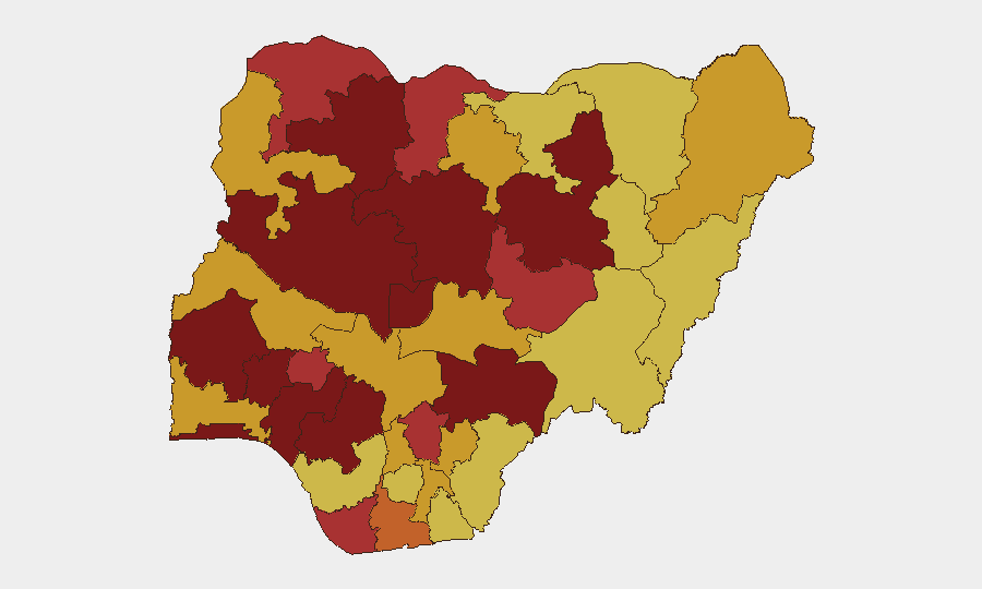
Situation Summary
Nigeria remains the second-highest threat environment globally, with 827 tracked security events driven predominantly by active insurgency, banditry, and kidnapping across multiple regions. The past two weeks have seen combined incident totals exceed recorded volumes for the entire 2003–2010 period, signaling a qualitative escalation in the operating environment. Armed robbery has spiked notably in major urban centers, and security responses by state governments indicate authorities are adopting restrictive measures to disrupt criminal logistics. The trajectory remains acute with no clear near-term de-escalation indicators.
Key Developments
- Kuru, Plateau State – 21 June 2026: Armed men approached the National Institute for Policy and Strategic Studies campus in Jos South LGA; security forces responded swiftly, contained the incident, and secured the facility. NIPSS management and broadcast media confirmed the "security incident," with no reported casualties among staff or damage to facilities. A formal investigation was opened.
- Katsina/Zamfara axis – 21 June 2026: Northwest governors announced emergency counter-banditry measures including a blanket ban on the sale, purchase, transport, and storage of petroleum products in jerrycans, aimed at cutting fuel supplies to armed groups operating across the region.
- Matazu and Musawa LGAs, Katsina State – 21 June 2026: State government ordered immediate closure of roadside fuel sales points and commercial phone-charging centers, identified as logistical and communications hubs for criminal networks.
- Owerri, Imo State – 18 June 2026 (widely circulated in past 48 hours): A coordinated night raid by at least six armed robbers targeted seven residential flats in one neighborhood, forcing residents to flee and resulting in significant property loss. CCTV footage has circulated widely on Nigerian social platforms, exemplifying deteriorating urban crime in the southeast.
- National security assessment – 21 June 2026: A public security analyst statement characterized the combined insurgency, kidnap, and banditry incidents of the past two weeks as historically severe, exceeding recorded totals for 2003–2010 and indicating a structurally worsened threat environment.
- Ongoing military operations – 23 June 2026: Nigerian conventional military forces remain engaged in active operations, consistent with ongoing counter-insurgency and counter-banditry campaigns across northern and central regions.
Highest-Risk Areas
Lagos State (100) and Oyo State (99.6) dominate the risk ranking, reflecting chronic urban crime, gang activity, and armed robbery in Nigeria's commercial heartland. The northwest and north-central corridor—Niger, Kaduna, and Zamfara States (97.8, 94.1, and 89.1 respectively)—faces persistent banditry, kidnapping, and insurgent activity. Edo State (85.2) remains elevated due to organized crime and trafficking networks. The spread of risk across 12 major administrative units indicates security pressure is nationwide rather than localized, with no safe haven for corporate or individual assets.
How GeoBit Would Assist
Corporate security teams should deploy Area-of-Interest (AOI) monitoring and early-warning alerts on Lagos, Oyo, Kaduna, and Niger States to track real-time incident clustering and threat actor movement. Network and actor analysis of bandit and insurgent groups—combined with OSINT fusion (X/Telegram monitoring, radio SIGINT, and multi-language search)—enables duty-of-care teams to forecast kidnap and robbery targeting patterns. Routing and network analysis can identify safer alternative routes for personnel and supply movements, while conflict and force-structure tracking provides situational awareness on security-force posture and military operations.
7-Day Outlook
No significant near-term de-escalation is anticipated. State-level logistics restrictions and military operations will continue, but bandit and insurgent group operational tempo is expected to remain elevated. Corporate and NGO personnel should anticipate increased checkpoints, temporary movement restrictions, and potential for secondary incident clusters in high-risk states through the coming week.
Highest-Risk Areas — Ranked
| # | State / Region | Risk |
|---|---|---|
| 1 | Lagos State | 100 |
| 2 | Oyo State | 99.6 |
| 3 | Niger State | 97.8 |
| 4 | Kaduna State | 94.1 |
| 5 | Zamfara State | 89.1 |
| 6 | Edo State | 85.2 |
| 7 | Osun State | 82.9 |
| 8 | Benue State | 81.4 |
| 9 | Bauchi State | 80.2 |
| 10 | Ondo State | 80.2 |
| 11 | Federal Capital Territory | 80.2 |
| 12 | Ekiti State | 79.3 |
Sources
Previous Daily Briefs
A new Nigeria brief is written every day — each with its own risk map and downloadable CSV. Here's the last week; use the calendar to go further back.
📅 Browse every day by calendar →
Highlighted days have a brief. Tap a day for that day's map & analysis, or “csv” for that day's dataset ($5).