Situation Summary
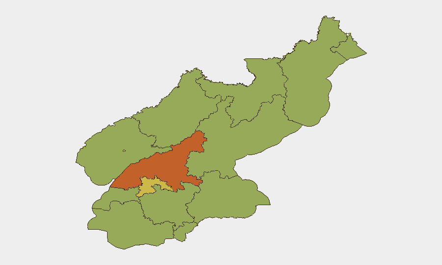
North Korea maintains a composite threat ranking of 62 (global position #37) with 24 tracked events over the monitoring period. Recent diplomatic tensions with the United States and South Korea, coupled with renewed international sanctions activity, have generated elevated public statements across multiple actors as of 18–20 June. The security environment remains volatile in border and port regions, with South Pyongan and Pyongyang presenting the highest sub-national risk concentrations (73.6 and 69.5 respectively).
Key Developments
- 2026-06-20 · Presidential Statement vs North Korea. A U.S. presidential statement on North Korea signals continued diplomatic pressure; full scope and impact require real-time assessment of statement content and tone.
- 2026-06-18 · Administrative Sanctions. U.S. Administration imposed fresh sanctions against North Korean entities; details on targeted sectors and enforcement mechanisms remain incomplete in available reporting.
- 2026-06-19 · North Korean Public Statement vs South Korea. Pyongyang issued a public statement directed at Seoul; escalatory rhetoric or strategic messaging requires monitoring for operational intent.
- 2026-06-19 · Blockade Event. A blockade event was recorded in North Korean territory or jurisdiction on 19 June; location, duration, and commercial/military scope require clarification.
- 2026-06-18 · UNESCO Statement. UNESCO issued a public statement concerning North Korea, suggesting potential cultural, heritage, or humanitarian dimensions to current tensions.
- 2026-06-19 · Arrest/Detention (U.S.-related). A detention or arrest event linked to North Carolina (likely a U.S. citizen or entity) occurred on 19 June; unclear whether this reflects North Korean action or U.S. law enforcement response.
Note: Metadata in available signals shows mixed geographic and actor fields. Corroboration of exact locations, parties, and operational scope requires live-feed intelligence and multi-source OSINT verification.
Highest-Risk Areas
South Pyongan (73.6) and Pyongyang (69.5) account for the majority of recorded threat signals and represent the primary risk concentration. South Pyongan's elevated score reflects port activity, border proximity to South Korea, and administrative/military infrastructure density. Pyongyang's rank reflects regime security apparatus, diplomatic friction, and international sanctions enforcement zones. All remaining provinces cluster at 43.6, indicating either uniform baseline risk or incomplete event attribution; border regions (North Pyongan, Ryanggang, Chagang) and coastal areas (Nampo, both Hamgyong provinces) warrant heightened vigilance for secondary escalation or supply-chain disruption.
How GeoBit Would Assist
Security teams with personnel or assets in North Korea should deploy AOI Monitoring & Early Warning on Pyongyang, port zones, and border crossings to detect operational changes in real time. Multi-language OSINT and X/Telegram intelligence enable rapid detection of regime statements, sanctions announcements, and cross-border incidents before traditional news cycles. Routing & Network Analysis can model alternative transit and supply chains in response to blockade or sanction events, while regime-stability and border-dispute search capabilities track long-term destabilization signals that may affect duty-of-care obligations.
7-Day Outlook
Diplomatic and sanctions activity is likely to persist through the week, with public statements and counter-statements dominating open-source signals. Maritime and border monitoring should remain elevated given the blockade event of 19 June; further restrictions on trade or movement cannot be ruled out. Personnel and asset security posture should remain at heightened vigilance until clarity emerges on scope and duration of recent administrative actions.
Highest-Risk Areas — Ranked
| # | State / Region | Risk |
|---|---|---|
| 1 | South Pyongan | 73.6 |
| 2 | P'yŏngyang | 69.5 |
| 3 | North Hamgyong | 46.3 |
| 4 | Ryanggang | 43.6 |
| 5 | North Pyongan | 43.6 |
| 6 | Chagang | 43.6 |
| 7 | Nampo | 43.6 |
| 8 | South Hwanghae | 43.6 |
| 9 | North Hwanghae | 43.6 |
| 10 | South Hamgyong | 43.6 |
| 11 | Kaesong | 43.6 |
| 12 | Kangwon | 43.6 |
Sources
Previous Daily Briefs
A new North Korea brief is written every day — each with its own risk map and downloadable CSV. Here's the last week; use the calendar to go further back.
📅 Browse every day by calendar →
Highlighted days have a brief. Tap a day for that day's map & analysis, or “csv” for that day's dataset ($5).