Situation Summary
Papua New Guinea remains at a composite threat level of 9 (rank 105 globally), with no credible security incidents, civil unrest, infrastructure disruptions, or travel-risk events documented in open sources over the past 24–48 hours. The security environment is characterized by persistent endemic risks—primarily tribal conflict, localized criminality, and political tensions—concentrated in the highlands provinces, but no acute escalation or new major incident has emerged to alter the baseline risk posture. Two health and geophysical signals remain under monitoring: circulating vaccine-derived poliovirus type 2 (cVDPV2) and a recent M 4.6 earthquake 74 km south of Panguna (Bougainville), neither of which has triggered secondary security or humanitarian crises in the reporting window.
Key Developments
No credible, time-verified security, conflict, civil unrest, major crime, or infrastructure-disruption incidents meeting verification and recency standards were identified in Papua New Guinea during the 24–48 hour window ending 12 July 2026 (UTC). Open-source monitoring across international news wires, regional media, and social platforms (including X/Twitter) yielded no reports of shootings, riots, large-scale protests, political crises, or critical service failures. Existing government travel advisories for Papua New Guinea remain unchanged and are not tied to any new incident. Routine localized crime and inter-community disputes may occur but are not being captured or reported in a manner that permits time-verified corroboration for this brief.
Highest-Risk Areas
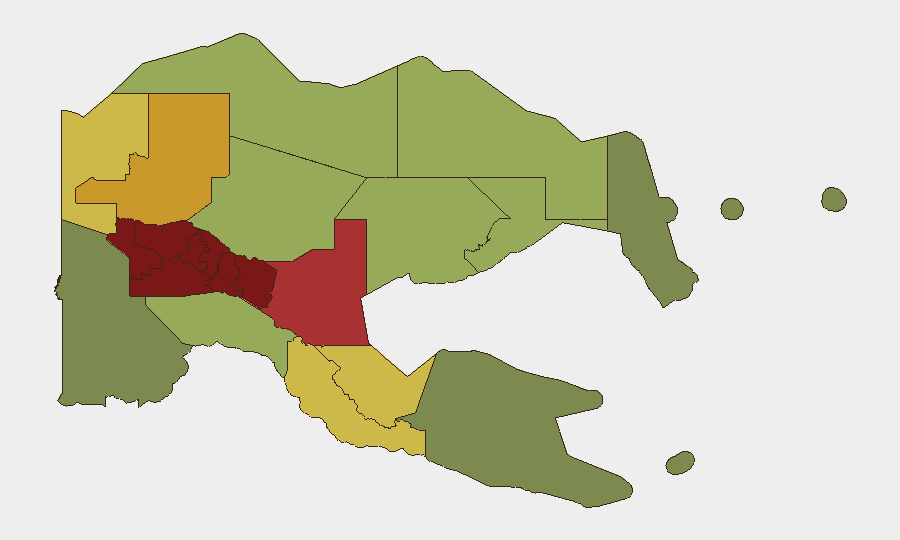
Southern Highlands, Enga, and Hela provinces drive the national risk ranking, each scoring 94–98 and reflecting longstanding tribal conflict, inter-communal violence, and weak law-enforcement presence. Eastern Highlands, Western Highlands, and Jiwaka round out the top six, with composite scores of 90–92, indicating similar drivers: customary violence, land disputes, and organized crime networks operating with limited state oversight. The National Capital District (Moresby), while lower-ranked at 85, remains a significant concern for corporate security due to robbery, carjacking, and gang activity concentrated in formal settlements and port/maritime infrastructure. These highland and urban risks are structural rather than event-driven and have not materially changed in the 24–48 hour window.
How GeoBit Would Assist
Security teams operating in or supporting Papua New Guinea should deploy AOI (Area-of-Interest) Monitoring & Early Warning on Southern Highlands, Enga, and Hela to detect escalation in tribal conflict or criminal activity via persistent OSINT fusion across news, social, and community signals. Intel Sweep and multi-language OSINT (including local-language social-media and radio-SIGINT monitoring) capture sub-reporting on localized incidents, security incidents, and political developments that may not reach international news wires. GIS & Spatial Analysis and alternative routing & network planning support duty-of-care logistics and personnel movement, minimizing exposure to highest-risk zones during operational travel.
7-Day Outlook
No acute security escalation is anticipated in the next 7 days absent new political, electoral, or tribal trigger events. Baseline risks—tribal violence in highlands, street crime in Port Moresby, and weak state capacity—will persist. Attention should remain on health developments (poliovirus circulation) and any spillover from regional defence-policy discussions (ongoing Pukpuk Treaty debate with Australia) that might influence domestic political stability.
Highest-Risk Areas — Ranked
| # | State / Region | Risk |
|---|---|---|
| 1 | Southern Highlands | 98 |
| 2 | Enga | 96 |
| 3 | Hela | 94 |
| 4 | Eastern Highlands | 92 |
| 5 | Western Highlands | 90 |
| 6 | Jiwaka | 88 |
| 7 | National Capital District | 85 |
| 8 | Simbu | 82 |
| 9 | Morobe | 78 |
| 10 | East Sepik | 72 |
| 11 | Sandaun | 68 |
| 12 | Oro | 66 |
Sources
Previous Daily Briefs
A new Papua New Guinea brief is written every day — each with its own risk map and downloadable CSV. Here's the last week; use the calendar to go further back.
📅 Browse every day by calendar →
Highlighted days have a brief. Tap a day for that day's map & analysis, or “csv” for that day's dataset ($5).
Atlas — our AI intelligence desk — emails them this snapshot personally. Nothing else, no list.