Situation Summary
Samoa remains in a stable security environment with no active civil unrest, political crisis, or significant crime waves reported in the past 48 hours. Recent police developments—including new K9 and ICT capabilities at the airport and in Apia—reflect capacity-building rather than response to emergent threats. The national composite threat score of 21 places Samoa in the lower-risk tier globally, with a flat near-term risk trajectory and no indicators of destabilization.
Key Developments
- Faleolo International Airport (Aʻana), 4 August 2026: Samoa Police formally opened a new Airport K9 Office and enhanced border security screening facility, funded by Australia and launched in an official ceremony. This capability expansion improves detection and interdiction at the primary international entry point.
- Tuanaimato, Apia (Tuamasaga), 4 August 2026: Official opening of a new SPPCS Assets & ICT Division warehouse to serve as a backup operational site for police and corrections services, strengthening emergency response and continuity planning.
- Tanugamanono supermarket, Apia (Tuamasaga), early August 2026: Three males from Tanugamanono arrested and charged in connection with the robbery of a 20-year-old male; Samoa Police emphasized robbery as a serious public safety threat and indicated court proceedings are underway.
- Safata II Constituency by-election (Upolu), early August 2026: Samoa Police confirmed full deployment and readiness for election-day policing; no unrest or voting-related incidents reported.
- Nationwide, past 48 hours: Multi-source monitoring (news outlets, official channels, social media) confirms no violent crime spikes, protests, infrastructure failures, or civil unrest across Samoa.
- Travel advisory status, current as of 6 July 2026: Australia's Smartraveller maintains "exercise normal safety precautions" for Samoa with no new heightened alerts or specific threats identified in the past month.
Highest-Risk Areas
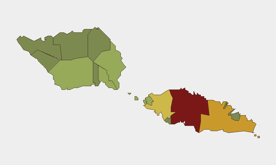
Tuamasaga (risk 85) and Ātua (risk 71) account for the majority of tracked sub-national risk, driven primarily by population concentration, urban crime (street robbery, property crime), and higher transient populations in Apia. Aʻana (risk 62) carries secondary risk owing to the international airport and port infrastructure; dispersed western districts (Faʻasaleleaga, Palauli, Satupaʻitea) and eastern areas show markedly lower risk profiles. The concentration of risk in the capital and immediate surroundings reflects standard urban security patterns rather than political instability or organized criminal networks.
How GeoBit Would Assist
Organizations with personnel or assets in Samoa should deploy AOI Monitoring & Early Warning on Tuamasaga and Ātua districts to track protest activity, crime clusters, and civil unrest indicators in near–real time. OSINT Fusion & Corroboration across local news, social media, and police channels provides early signal of emerging incidents before they escalate. Routing & Network Analysis supports journey planning for staff traveling between Apia, the airport, and outer districts, identifying safer routes and transit windows based on historical crime patterns and current event feeds.
7-Day Outlook
No significant security deterioration is forecast for the next seven days. Routine police capacity-building activities and the Safata II by-election present no destabilizing indicators. Organizations should maintain standard duty-of-care protocols and monitor Tuamasaga for isolated street crime, but escalation to regional instability remains unlikely absent a major unexpected political or economic shock.
Highest-Risk Areas — Ranked
| # | State / Region | Risk |
|---|---|---|
| 1 | Tuamasaga | 85 |
| 2 | Ātua | 71 |
| 3 | Aʻana | 62 |
| 4 | Aiga-i-le-Tai | 55 |
| 5 | Faʻasaleleaga | 48 |
| 6 | Palauli | 42 |
| 7 | Satupaʻitea | 38 |
| 8 | Gagaʻemauga | 35 |
| 9 | Gagaʻifomauga | 32 |
| 10 | Vaisigano | 28 |
| 11 | Vaʻa-o-Fonoti | 23 |
Sources
Previous Daily Briefs
A new Samoa brief is written every day — each with its own risk map and downloadable CSV. Here's the last week; use the calendar to go further back.
📅 Browse every day by calendar →
Highlighted days have a brief. Tap a day for that day's map & analysis, or “csv” for that day's dataset ($5).
Atlas — our AI intelligence desk — emails them this snapshot personally. Nothing else, no list.