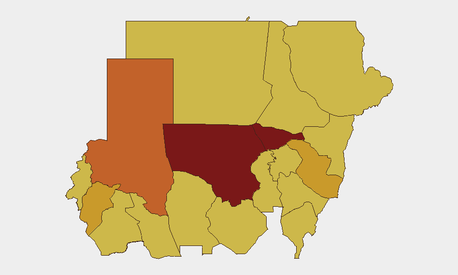
Situation Summary
Sudan remains in acute civil conflict, ranking #10 globally with a composite threat score of 100 driven primarily by sustained warfare between the Sudanese Armed Forces (SAF) and the Rapid Support Forces (RSF). Over the past 48 hours, the threat picture has sharpened around two discrete flashpoints: an RSF offensive posture against SAF-held El Obeid in North Kordofan (the nation's highest-risk state at score 100), and emerging tribal-security tensions in Red Sea State. The convergence of military escalation in the center-north and civil unrest along the eastern frontier suggests a widening operational and geographic scope of instability.
Key Developments
- El Obeid, North Kordofan (2026-06-18 to 2026-06-20): RSF forces have established logistics positions and staged concentrations near Kazgil and Umm Sumeima, indicating active preparations for an offensive against SAF-held El Obeid. This represents a material shift in RSF operational posture in the state.
- El Obeid, North Kordofan (2026-06-18 to 2026-06-20): Sustained drone bombardment has struck civilian infrastructure including fuel stations, with reported civilian casualties. Simultaneous SAF drone and ground counteractions indicate active kinetic engagement.
- Main east–west highway corridor (2026-06-18 to 2026-06-20): RSF drone operations have expanded beyond El Obeid to broader population centers along Sudan's primary east–west transport artery, degrading fuel supply lines and weakening SAF logistics in the region.
- Al-Rataj, Halaib locality, Red Sea State (2026-06-18 to 2026-06-20): Red Sea State security authorities deployed military reinforcements to contain escalating tribal friction between Bishariyn and Rashaida groups, signaling civil-unrest risk in the border zone near Egypt.
- Recent international pressure (2026-06-19 to 2026-06-21): The UN issued public statements and conventional military force postures against Sudan on 2026-06-21; Norway issued threats the same day. These signals reflect hardening international diplomatic and potential enforcement pressure concurrent with deteriorating ground conditions.
Highest-Risk Areas
North Kordofan State (risk 100) is the dominant driver of national risk, with active RSF offensive staging and sustained drone attacks on SAF positions and civilian infrastructure. Al Khartum (82.8) remains the capital-region flashpoint. The Darfur states (North, Central, South—all 71–73 range) and eastern corridor states (Blue Nile, Red Sea, Kassala, Sennar—all 70) form a secondary tier of sustained conflict and emerging civil-unrest risk. The concentration of activity in North Kordofan and the simultaneous tribal escalation in Red Sea State indicate that risk is not retreating but fragmenting and widening geographically.
How GeoBit Would Assist
Teams with personnel or assets in Sudan should employ AOI Monitoring & Early Warning on North Kordofan and Red Sea State to detect shifts in RSF staging, SAF repositioning, or tribal mobilization in real time. Conflict & Military capabilities (force-structure tracking, battle mapping, weapons-capability monitoring) would illuminate RSF and SAF logistics, drone operations, and offensive/defensive postures. GIS & Spatial Analysis combined with Routing & Network Analysis would allow security teams to model safe corridors, assess supply-line vulnerability, and plan alternative movement routes around the active conflict zone.
7-Day Outlook
RSF offensive activity around El Obeid is likely to intensify or culminate within the next week; SAF counteraction will remain kinetic. Tribal tensions in Red Sea State pose a secondary risk of civil unrest that could disrupt port operations or border stability. International pressure on Sudan is expected to persist, raising the risk of external military intervention or enforcement actions.
Highest-Risk Areas — Ranked
| # | State / Region | Risk |
|---|---|---|
| 1 | North Kordofan State | 100 |
| 2 | Al Khartum | 82.8 |
| 3 | North Darfur State | 73 |
| 4 | Al Qadarif State | 71.5 |
| 5 | Central Darfur State | 71.5 |
| 6 | Blue Nile | 70 |
| 7 | River Nile State | 70 |
| 8 | Aj Jazira | 70 |
| 9 | Red Sea State | 70 |
| 10 | Kassala State | 70 |
| 11 | Sennar State | 70 |
| 12 | South Darfur State | 70 |
Sources
Previous Daily Briefs
A new Sudan brief is written every day — each with its own risk map and downloadable CSV. Here's the last week; use the calendar to go further back.
📅 Browse every day by calendar →
Highlighted days have a brief. Tap a day for that day's map & analysis, or “csv” for that day's dataset ($5).