Situation Summary
Suriname remains a low-threat country by global composite ranking (score 12), but risk is highly concentrated in interior and eastern regions where state capacity is limited and transnational criminal activity is elevated. A demonstration involving the Prime Minister was recorded in Paramaribo on 24 July; live research did not independently verify additional security incidents in the past 48 hours. Overall trajectory is stable, though interior drug-trafficking corridors and maritime smuggling routes continue to pose chronic risks to corporate operations and supply chains.
Key Developments
- Paramaribo, 24 July 2026: Demonstration/rally involving Prime Minister documented; specific triggers, participation scale, and outcome not independently corroborated in current reporting.
- Interior regions (early July): Three law-enforcement events recorded in early July; live research has not yet independently verified incident locations, casualty counts, or outcomes in the 24–48 hour window.
Note: Live web research over the past 24–48 hours did not surface additional independently corroborated security incidents above the threshold for inclusion in this brief. Secondary archive sources reference events (e.g., Chinese national arrests in Brokopondo, maritime incidents in July) that either fall outside the required timeframe or lack current verification from multiple independent sources.
Highest-Risk Areas
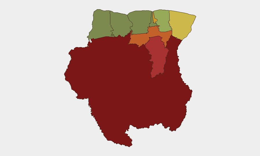
Sipaliwini (risk 92), Brokopondo (78), and Para (74) constitute the primary threat landscape. These interior and eastern districts are characterized by limited state presence, dense rainforest terrain, and proximity to trafficking routes for narcotics and smuggled goods transiting to/from Brazil and the Caribbean. Paramaribo (71) and Marowijne (68) reflect urban and border-zone vulnerabilities related to organized crime, police capacity constraints, and cross-border movement. By contrast, Nickerie (8) and Coronie (12) in the west show substantially lower composite risk; western coastal and agricultural zones present fewer acute threats to corporate operations.
How GeoBit Would Assist
Teams with personnel or assets in Suriname should deploy AOI Monitoring & Early Warning on high-risk districts (Sipaliwini, Brokopondo, Para) to catch emerging trafficking, unrest, or criminal activity before operational impact. OSINT fusion (X/Twitter, Telegram, local news sources) and multi-language search will provide real-time color on demonstrations, law enforcement actions, and supply-chain disruptions in Paramaribo and border zones. Maritime tracking and routing & network analysis enable identification of alternative supply routes and detection of vessel movements in waters where smuggling and piracy incidents have occurred, reducing logistics exposure in high-risk seasons.
7-Day Outlook
No major escalation is anticipated in the near term; the 24 July demonstration has not signaled broader instability. Interior criminal activity and transnational smuggling will likely persist at chronic baseline levels. Corporate security teams should maintain standard duty-of-care protocols for staff in Paramaribo and exercise heightened vigilance for any personnel transiting Sipaliwini, Brokopondo, or Para; live monitoring of police and border agency communications would provide early warning of localized incidents.
Highest-Risk Areas — Ranked
| # | State / Region | Risk |
|---|---|---|
| 1 | Sipaliwini | 92 |
| 2 | Brokopondo | 78 |
| 3 | Para | 74 |
| 4 | Paramaribo | 71 |
| 5 | Marowijne | 68 |
| 6 | Commewijne | 42 |
| 7 | Wanica | 38 |
| 8 | Saramacca | 29 |
| 9 | Coronie | 12 |
| 10 | Nickerie | 8 |
Previous Daily Briefs
A new Suriname brief is written every day — each with its own risk map and downloadable CSV. Here's the last week; use the calendar to go further back.
📅 Browse every day by calendar →
Highlighted days have a brief. Tap a day for that day's map & analysis, or “csv” for that day's dataset ($5).
Atlas — our AI intelligence desk — emails them this snapshot personally. Nothing else, no list.