Situation Summary
Syria remains globally ranked #9 for composite threat, driven by active civil war, multi-actor fragmentation, and 271 tracked security events. The past 48 hours have seen scattered but geographically dispersed violence—Turkish drone strikes in the northeast, ISIS-SDF clashes in the east, localized assassinations in the south, and front-line artillery exchanges in the north—indicating no unified de-escalation but rather persistent low-to-medium intensity conflict across multiple theaters. Damascus has tightened internal checkpoints, suggesting heightened regime security concern. The overall trajectory remains volatile with no clear resolution mechanisms.
Key Developments
- Qamishli, Hasakah (20 Jun): Turkish drone strike on a vehicle west of Qamishli city killed at least one SDF/Asayish-affiliated figure and wounded others; consistent with ongoing Turkish targeting patterns in Kurdish-held northeast.
- Al-Busayrah, Deir ez-Zor (19–20 Jun night): SDF security units clashed with an ISIS cell following an attempted ambush on an SDF checkpoint; at least one suspected ISIS fighter killed and several arrested; localized gunfire and explosions reported.
- Tafas, Daraa (19 Jun): Armed men assassinated a former opposition fighter who had reconciled with the government, reflecting ongoing tit-for-tat killings between local armed networks and regime-linked elements in western Daraa.
- Jabal al-Akrad, Latakia–Idlib border (19 Jun): Syrian army and allied forces exchanged artillery and rocket fire with opposition factions; shells landed near Kabani and surrounding high ground, indicating elevated shelling and UXO risk in front-line rural areas.
- Afrin, northern Aleppo (19 Jun): A roadside IED detonated against a Turkish-backed faction military vehicle in central Afrin city, injuring several fighters and damaging nearby vehicles; highlights persistent IED risk in busy urban zones.
- Damascus city (19 Jun): Tightened checkpoints and spot searches reported in central areas (Mezzeh, Kafr Sousa) following unconfirmed reports of a foiled explosives transfer; indicates elevated short-term internal security posture despite lack of official statement.
Highest-Risk Areas
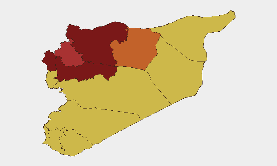
Hama Governorate (risk 100) and Damascus Governorate (89.6) lead the sub-national ranking, followed by Aleppo (86.9) and Lattakia (82.8). Hama's position reflects sustained front-line military activity and irregular armed group presence; Damascus's score reflects regime-focused security threats, checkpoint intensity, and urban targeting patterns. Aleppo and Lattakia are driven by Turkish-backed faction dynamics, IED incidents, and proximity to opposition-held Idlib. The clustering of high-risk zones along north–south axes (Idlib–Lattakia–Aleppo corridor) and in the capital indicates that mobility, supply routes, and regime-security operations remain primary vulnerability vectors for personnel and assets.
How GeoBit Would Assist
Security teams should deploy AOI Monitoring & Early Warning on high-risk governorates (Hama, Damascus, Aleppo) and specific flash-point towns (Qamishli, al-Busayrah, Tafas, Afrin) to detect emerging violence patterns and insurgent activity before escalation. Routing & Network Analysis can model safer alternative routes around front-line zones and checkpoint-dense areas in Damascus and western Daraa. OSINT fusion—combining X/Telegram field reports, satellite imagery, and multi-language conflict feeds—enables near-real-time situational awareness of minor incidents (IEDs, clashes, arrests) that open-source media delays or omits.
7-Day Outlook
No major ceasefire or political shift is expected in the next week. Localized ISIS-SDF clashes in the east and Turkish drone activity in the northeast will likely persist; front-line artillery exchanges along Idlib–Lattakia will remain episodic. Damascus regime security posture may remain elevated, creating checkpoint and search friction for personnel transit. Personnel in Hama, Aleppo, and Daraa should expect continued medium-level kinetic and assassination risk.
Highest-Risk Areas — Ranked
| # | State / Region | Risk |
|---|---|---|
| 1 | Hama Governorate | 100 |
| 2 | Damascus Governorate | 89.6 |
| 3 | Aleppo Governorate | 86.9 |
| 4 | Lattakia Governorate | 82.8 |
| 5 | Idleb Governorate | 78.1 |
| 6 | Ar-Raqqa Governorate | 74 |
| 7 | Tartus Governorate | 70 |
| 8 | UNDOF | 70 |
| 9 | Al-Quneitra Governorate | 70 |
| 10 | Dar'a Governorate | 70 |
| 11 | Homs Governorate | 70 |
| 12 | Rif Dimashq Governorate | 70 |
Sources
Previous Daily Briefs
A new Syria brief is written every day — each with its own risk map and downloadable CSV. Here's the last week; use the calendar to go further back.
📅 Browse every day by calendar →
Highlighted days have a brief. Tap a day for that day's map & analysis, or “csv” for that day's dataset ($5).