Situation Summary
Trinidad and Tobago faces a fragmented but persistent security environment characterized by localized gang violence, homicides targeting specific groups (taxi drivers, alleged gang figures), and sporadic attacks on critical infrastructure and media workers. The past week has seen multiple shooting incidents concentrated in high-risk southern and central zones, alongside ongoing police operations and detention-facility incidents. No nationwide unrest or systemic breakdown is evident, but the frequency and targeting pattern of recent violence suggest localized instability in specific corridors, particularly around Port of Spain, central Trinidad, and Tobago's Lowlands district.
Key Developments
- Lowlands, Tobago – suspected arson on journalist's vehicle (Fri 24 Jul, ~2:00 a.m.): TV6 Tobago journalist Elizabeth Williams' van was deliberately set on fire outside her home; her daughter extinguished the flames before total loss. Police investigation ongoing; first confirmed media-targeting incident in current reporting window.
- Chaguanas – taxi driver homicide (Thu 23 Jul, evening): 33-year-old taxi driver Joel Macoon shot and killed in New Settlement, Caroni Savannah Road; police assess as targeted attack, not random. Reflects elevated risk to transport sector workers.
- Morvant – gang-figure shooting during police operation (Thu 23 Jul, evening): Alleged gang member "Fishie" shot multiple times outside residence during wider police anti-gang crackdown; transported to hospital in critical condition. Indicates active law-enforcement operations in high-risk Port of Spain suburb with potential for retaliatory escalation.
- Penal – Venezuelan nationals shot near police station (recent Sunday early hours): 23-year-old Venezuelan man killed, another wounded in shooting outside bar metres from Penal Police Station. Signals ongoing firearms violence and vulnerability near nightlife venues even in proximity to law-enforcement presence.
- Immigration Detention Centre, Arima – ongoing manhunt (8 Venezuelan escapees remain at large as of mid-week update, following Sat 18 Jul escape): While the escape occurred 8+ days ago, seven fugitives remain unlawfully at large nationwide following police recapture operations. Authorities warn public not to harbor escapees; poses persistent public-order risk.
- Maximum Security Prison, Arouca – murder charge announced (Fri 24 Jul): 35-year-old inmate formally charged in connection with fellow prisoner Christopher Banfield's death (earlier in year). Reflects ongoing intra-facility violence concerns.
- Political security – preventive detention orders revoked (Thu 23 Jul): Businessman Dominic Hadeed and wife released after ~1 month in preventive custody under alleged plot to assassinate Prime Minister Kamla Persad-Bissessar. Ministry of Homeland Security revoked orders; no active threat assessment disclosed publicly.
Highest-Risk Areas
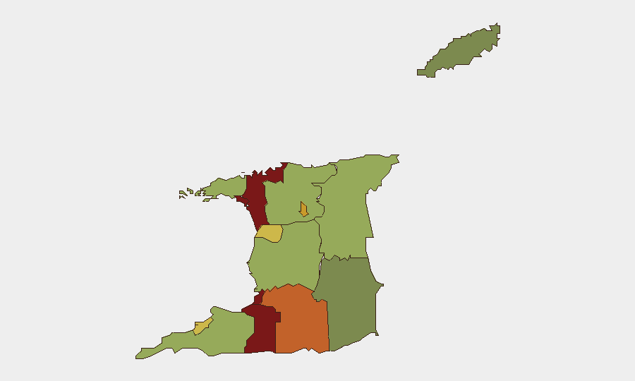
San Juan-Laventille, Port of Spain, and Penal-Debe dominate the sub-national risk ranking (scores 95, 88, and 82 respectively), with Morvant and Arima also showing elevated concern. These zones concentrate gang-related violence, firearms homicides, and police enforcement operations. The concentration of recent incidents—taxi driver killing in Chaguanas, gang shootings in Morvant, detention-center escape fallout in Arima—aligns with the ranking, suggesting the algorithmic assessment reflects genuine localized instability rather than statistical artifact. Tobago's Lowlands incident represents a lower-frequency but qualitatively significant outlier (media targeting).
How GeoBit Would Assist
Security teams operating in or transiting Trinidad and Tobago would benefit from AOI Monitoring & Early Warning focused on the 12 highest-risk sub-national zones, OSINT fusion (X/Twitter, local news feeds) to track gang activity and police operations in real time, and Network & Actor Analysis to map relationships between escapees, gang figures, and locales. Routing & Network Analysis would enable alternative-route planning for personnel avoiding Chaguanas, Morvant, and San Juan-Laventille during high-risk hours.
7-Day Outlook
Homicide frequency and targeting specificity (transport workers, gang figures, media workers) suggest tactical rather than random violence, indicating low probability of mass civilian disruption but sustained individual-level risk. Police anti-gang operations will likely continue, with potential for retaliatory incidents in Morvant and surrounding Port of Spain suburbs over the next 5–7 days. The ongoing manhunt for seven escapees remains a secondary concern pending recaptures.
Highest-Risk Areas — Ranked
| # | State / Region | Risk |
|---|---|---|
| 1 | San Juan-Laventille | 95 |
| 2 | Port of Spain | 88 |
| 3 | Penal-Debe | 82 |
| 4 | San Fernando | 80 |
| 5 | Princes Town | 75 |
| 6 | Arima | 72 |
| 7 | Chaguanas | 68 |
| 8 | Point Fortin | 65 |
| 9 | Diego Martin | 58 |
| 10 | Siparia | 55 |
| 11 | Couva-Tabaquite-Talparo | 52 |
| 12 | Sangre Grande | 48 |
Sources
Previous Daily Briefs
A new Trinidad and Tobago brief is written every day — each with its own risk map and downloadable CSV. Here's the last week; use the calendar to go further back.
📅 Browse every day by calendar →
Highlighted days have a brief. Tap a day for that day's map & analysis, or “csv” for that day's dataset ($5).
Atlas — our AI intelligence desk — emails them this snapshot personally. Nothing else, no list.