Situation Summary
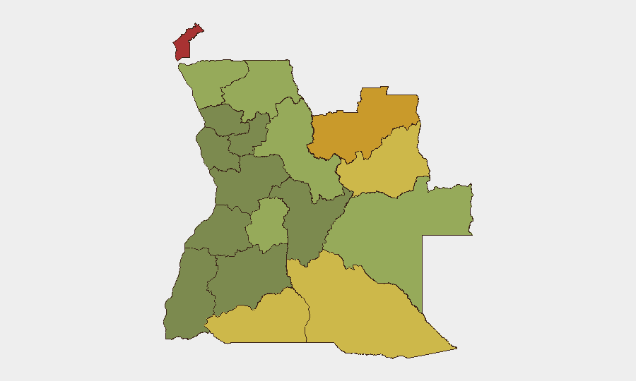
Angola remains a moderate-risk operating environment (global rank #51) with no acute security incidents reported in the last 24–48 hours. The security posture in the capital is currently elevated but orderly due to the African Chiefs of Defense Conference 2026 (29 Jun–4 Jul), which has brought increased checkpoints and traffic management to central Luanda without triggering unrest. Underlying structural risk is concentrated in resource-extraction zones in the northeast and east; the broader trajectory is stable absent new triggers.
Key Developments
- Luanda – 29 Jun to 4 Jul – African Chiefs of Defense Conference 2026 in session with 35+ nations represented. Increased security checkpoints and localized traffic disruptions reported; no violence or civil unrest recorded in the last 24–48 hours. Conference expected to conclude by 5 July with subsequent normalization of security posture.
- Luanda Province & northern/eastern regions – late Jun to 5 Jul – Active wildfire activity ongoing across multiple zones, affecting air quality and visibility on secondary routes. No security or conflict linkage identified; fires remain an environmental and emergency-services issue with potential for localized evacuation or road disruption.
- Nationwide – 3–4 Jul – No corroborated armed clashes, terrorist attacks, mass protests, major crime events targeting foreigners, or sudden infrastructure failures detected in open-source monitoring.
- Luanda – 30 Jun to 4 Jul – Routine high-level U.S.–Angola military bilateral engagement and ACHOD 2026 participation documented. No security breaches or hostile acts reported around diplomatic activity.
Highest-Risk Areas
Risk is heavily concentrated in Angola's resource-rich northeastern and eastern provinces. Cabinda (risk 78), Lunda Norte (72), and Lunda Sul (68) dominate the threat landscape, driven by competition for mineral resources, border permeability, and limited state capacity in remote areas. Cuando Cubango, Cunene, and Moxico provinces (64, 62, 58 respectively) reflect similar structural pressures along the southern and eastern borders. By contrast, Luanda and the western corridor carry significantly lower risk scores, making the capital and coastal zones suitable for routine operations under standard duty-of-care protocols.
How GeoBit Would Assist
A corporate security team with personnel or assets in Angola should leverage AOI (Area-of-Interest) Monitoring & Early Warning on Cabinda, Lunda Norte/Sul, and border zones to detect emerging trafficking, armed activity, or civil unrest before escalation. Concurrent Intel Sweep and multi-language OSINT fusion (including X/Twitter, Telegram, and local news feeds) provide real-time corroboration of reported incidents and early signals of policy shifts or workforce disruption. Routing & Network Analysis supports secure travel planning for personnel moving between Luanda and interior operations, accounting for wildfire impacts and checkpoint locations during elevated security periods.
7-Day Outlook
The heightened security posture in Luanda is expected to normalize after 5 July absent new triggers. No indicators currently suggest imminent conflict, mass unrest, or policy changes in the near term. Persistent monitoring of the high-risk northeastern provinces and environmental conditions (wildfires) remains the principal duty-of-care requirement for sustained operations.
Highest-Risk Areas — Ranked
| # | State / Region | Risk |
|---|---|---|
| 1 | Cabinda Province | 78 |
| 2 | Lunda Norte Province | 72 |
| 3 | Lunda Sul Province | 68 |
| 4 | Cuando Cubango Province | 64 |
| 5 | Cunene Province | 62 |
| 6 | Moxico Province | 58 |
| 7 | Zaire Province | 54 |
| 8 | Huambo Province | 50 |
| 9 | Uíge Province | 48 |
| 10 | Malanje Province | 42 |
| 11 | Bié Province | 35 |
| 12 | Huíla Province | 32 |
Sources
Previous Daily Briefs
A new Angola brief is written every day — each with its own risk map and downloadable CSV. Here's the last week; use the calendar to go further back.
📅 Browse every day by calendar →
Highlighted days have a brief. Tap a day for that day's map & analysis, or “csv” for that day's dataset ($5).
Atlas — our AI intelligence desk — emails them this snapshot personally. Nothing else, no list.