Situation Summary
The Bahamas faces persistent, elevated crime and security volatility concentrated in Nassau (New Providence) and Freeport, with baseline homicide, robbery, and migrant-trafficking activity remaining the primary threats to corporate personnel and assets. Recent event signals flagged by GeoBit include school threats, unconventional violence incidents involving commercial entities, and serial-crime violence, though corroborated detail on most flagged events remains limited in open-source channels as of 02 August 2026. The composite national threat score of 43 reflects this localized but significant risk profile; trajectory remains stable but alert-dependent rather than trending downward.
Key Developments
- School threat reported, New Providence, 02 August 2026: GeoBit signal flagged a school-related threat event; no cross-verified detail available in current research. Recommend immediate clarification through corporate site security and local liaison contacts.
- Power station incident, Nassau area, recent (late July): Lightning strike and explosion at Bahamas Power and Light's Blue Hills Power Station caused localized outages affecting airport and Princess Margaret Hospital; full timeline and recovery status require verification.
- Maritime interdiction, Northern Exuma / Norman's Cay, 27 July 2026: Royal Bahamas Defence Force and OPBAT intercepted 54 Haitian migrants and suspected narcotics; incident reflects ongoing migrant-trafficking and drug-transit vulnerability on southern maritime approaches.
- Fatal shooting, Chippingham, Nassau, 26 July 2026: One fatality; two additional stabbing victims reported in Palm Beach on the same date. Consistent with baseline crime pattern but underscores gang-related violence risk in residential areas of New Providence.
- Unconventional violence signals, Royal Caribbean involvement, 02 August & 31 July 2026: GeoBit flagged two unconventional violence events linked to Royal Caribbean; substantiation and specific location/nature not yet confirmed in open research. Escalation or criminal targeting of cruise/maritime commerce requires urgent clarification.
- Demand/rejection signals, political/civic context, late July 2026: Multiple "demand" and "reject" signals flagged between Bahamian actors, a senator, and voter groups (31 July) and between government/legislative branches (31 July). Likely reflects electoral or policy tension; risk to corporate operations indirect unless venue/personnel proximity is high.
Highest-Risk Areas
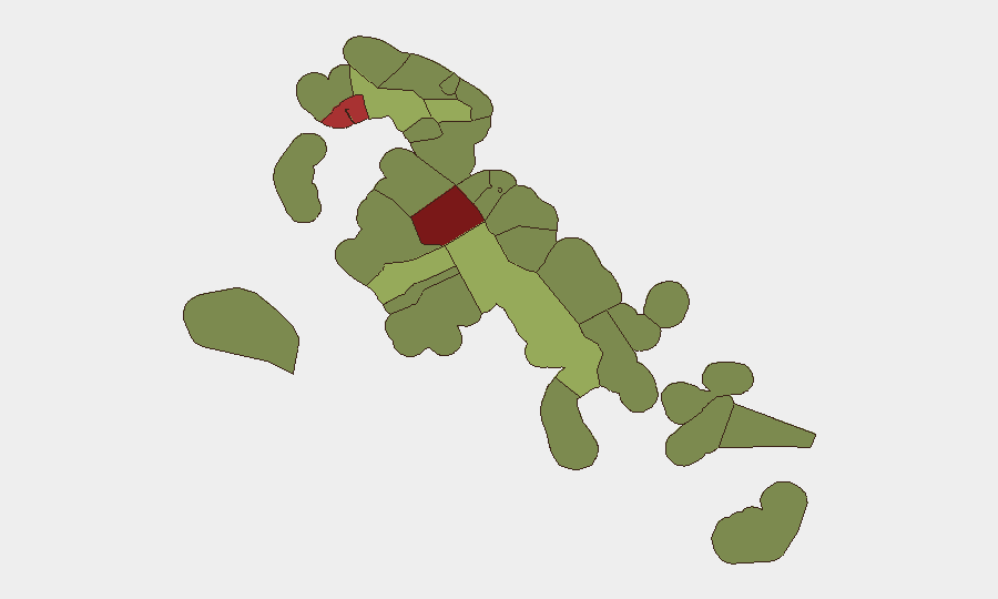
New Providence (risk 92) and Freeport (risk 78) dominate the sub-national ranking and account for the majority of reported violent crime, migrant processing disruption, and commercial-sector incidents. Central Abaco (52) and Central Andros (48) show secondary concern, primarily driven by maritime trafficking and law-enforcement volatility. All remaining regions score below 50 and represent manageable baseline risk for well-resourced corporate operations; however, the steep concentration in New Providence means >70% of corporate staffing and asset exposure faces the highest-risk environment in the region.
How GeoBit Would Assist
Security teams operating in the Bahamas should employ AOI Monitoring & Early Warning on New Providence and Freeport to flag incidents affecting corporate facilities, residences, and commute corridors in near-real time. Maritime & Aviation tracking coupled with OSINT fusion on migrant-trafficking and narcotics interdiction activity will provide early signal of port, airport, and logistics disruption. Network & Actor Analysis targeting Bahamian criminal and political networks will distinguish electoral noise from operational threats to personnel and assets.
7-Day Outlook
Crime and trafficking activity are forecast to remain at baseline levels; no new escalation or organized security threat is apparent over the next seven days. Monitoring of the flagged school threat and Royal Caribbean incidents is essential; if either event escalates or is corroborated as a credible threat to commercial infrastructure, risk posture in New Providence will require reassessment.
Highest-Risk Areas — Ranked
| # | State / Region | Risk |
|---|---|---|
| 1 | New Providence | 92 |
| 2 | City of Freeport | 78 |
| 3 | Central Abaco | 52 |
| 4 | Central Andros | 48 |
| 5 | Exuma | 45 |
| 6 | East Grand Bahama | 42 |
| 7 | South Andros | 38 |
| 8 | North Abaco | 35 |
| 9 | North Eleuthera | 33 |
| 10 | South Abaco | 32 |
| 11 | Cat Island | 30 |
| 12 | Mangrove Cay | 28 |
Sources
Previous Daily Briefs
A new Bahamas brief is written every day — each with its own risk map and downloadable CSV. Here's the last week; use the calendar to go further back.
📅 Browse every day by calendar →
Highlighted days have a brief. Tap a day for that day's map & analysis, or “csv” for that day's dataset ($5).
Atlas — our AI intelligence desk — emails them this snapshot personally. Nothing else, no list.