Situation Summary
The Bahamas maintains a baseline security posture characterized by persistent street-level and organized crime concentrated in Nassau and Freeport, with no major civil unrest, political instability, or conflict dynamics. The current 24–48-hour window shows no confirmed discrete security incidents or travel-risk events; the threat environment remains stable but operationally unchanged from the longer-term pattern. Corporate assets and personnel in-country face endemic rather than acute risk, driven primarily by property crime, armed robbery, and narcotics-related violence in high-density urban zones. Trajectory remains flat absent new policy, enforcement, or criminal-organization escalation.
Key Developments
- No confirmed new security or travel-risk incidents in the last 24–48 hours across The Bahamas (national and all sub-national zones). Open-source news, social media, and security monitoring show only routine baseline crime reporting with no discrete events meeting current-window criteria.
- Historical context (not current): Spanish Cay, Abaco – a construction-transport boat explosion resulting in one fatality occurred several days prior to the current assessment window and does not constitute a new 24–48-hour development.
- U.S. State Department Level 2 travel advisory remains in effect (last updated prior to current window), citing gang violence, armed robbery, and property crime as primary hazards in Nassau, Freeport, and outlying areas. No policy shift or advisory escalation has been reported in the last 48 hours.
- New Providence (Nassau metro) and Freeport continue as primary crime and violence hotspots, consistent with weeks-long trend; no new flashpoint districts or expansion of high-risk zones reported in current window.
Highest-Risk Areas
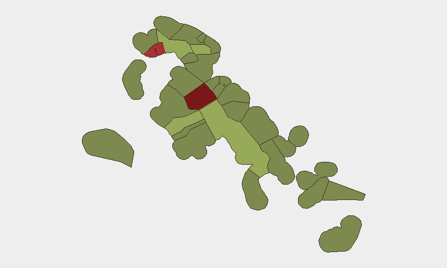
New Providence and Freeport dominate the sub-national risk matrix, with composite scores of 92 and 78 respectively, reflecting sustained gang-related homicide, armed robbery, and drug-trafficking violence concentrated in inner-city neighborhoods and port facilities. Central Abaco (52) and Central Andros (48) show elevated secondary risk, likely linked to inter-island narcotics trafficking, maritime vulnerability, and lower police presence. Outer islands (Cat Island, Mangrove Cay, North Eleuthera) remain relatively insulated from organized crime and violent crime, though property and petty theft persist. Corporate personnel and assets in Nassau should assume heightened vigilance; Freeport operations require equivalent precautions; outer-island and resort zones present materially lower acute threat.
How GeoBit Would Assist
Security teams would employ AOI Monitoring & Early Warning to flag violence upticks or gang activity escalation in New Providence and Freeport with persistent alerting; OSINT fusion and social-media intelligence (X, Telegram, local news feeds, Spanish-language platforms) to detect emerging threats, cartel communication, or organized-crime coordination ahead of street-level manifestation; and alternative-route and network analysis to identify safe transit corridors and supply-chain workarounds during periods of localized unrest. Entity extraction and sentiment analysis on criminal-justice and political messaging would provide early signal of policy shifts or enforcement changes affecting corporate safety. Regular intel sweeps on maritime and aviation security would monitor trafficking routes and transnational crime dynamics affecting Bahamas transit and port facilities.
7-Day Outlook
No imminent escalation or major incident is forecast; the near-term security picture is expected to remain consistent with the current baseline of endemic street crime and organized-drug-trafficking activity. Monitoring for seasonal tourism surges, public holidays, or police enforcement initiatives that could trigger short-term localized volatility is recommended. Personnel security protocols in Nassau and Freeport should remain at current heightened posture.
Highest-Risk Areas — Ranked
| # | State / Region | Risk |
|---|---|---|
| 1 | New Providence | 92 |
| 2 | City of Freeport | 78 |
| 3 | Central Abaco | 52 |
| 4 | Central Andros | 48 |
| 5 | Exuma | 45 |
| 6 | East Grand Bahama | 42 |
| 7 | South Andros | 38 |
| 8 | North Abaco | 35 |
| 9 | North Eleuthera | 33 |
| 10 | South Abaco | 32 |
| 11 | Cat Island | 30 |
| 12 | Mangrove Cay | 28 |
Sources
Previous Daily Briefs
A new Bahamas brief is written every day — each with its own risk map and downloadable CSV. Here's the last week; use the calendar to go further back.
📅 Browse every day by calendar →
Highlighted days have a brief. Tap a day for that day's map & analysis, or “csv” for that day's dataset ($5).
Atlas — our AI intelligence desk — emails them this snapshot personally. Nothing else, no list.