Situation Summary
Bahrain faces an acute external security escalation following a 24 July 2026 missile and drone attack attributed to Iran, which triggered nationwide air-raid sirens and confirmed interceptions by the Bahrain Defense Force. Domestic civil unrest—including territory occupations by Bahraini nationals and expatriates, arrests, and detention-related protests—compounds the threat picture, particularly in the Northern and Southern Governorates. The composite threat score of 35 and 8 tracked events over the assessment period indicate elevated but manageable risk; however, the trajectory is upward, driven by regional escalation and latent domestic friction.
Key Developments
- Nationwide, Bahrain — 24 Jul 2026 — Ministry of Interior activated air-raid sirens and ordered citizens and residents to shelter immediately following detection of incoming missiles and drones; the Bahrain Defense Force confirmed successful interception and destruction of multiple hostile aerial systems.
- Nationwide, Bahrain — 24 Jul 2026 — A second siren activation occurred the same day, indicating sustained or repeated threat activity and requiring continuation of civil-defense protocols beyond the initial all-clear.
- Shaikh Isa bin Salman Causeway (toward Muharraq) — 24 Jul 2026 — Authorities announced precautionary closure of left and middle lanes from Friday 00:00 to Sunday 05:00 as a direct consequence of the security incident.
- Multiple locations, Bahrain — 27–28 Jul 2026 — Territory occupation events by Bahraini nationals and expatriate groups were reported; concurrent arrests and detention-related public disapproval signals suggest ongoing civil unrest tied to judicial or penal-system grievances.
- Bahrain (diplomatic/threat environment) — 26–28 Jul 2026 — Iranian threats directed at Bahrain, Bahraini counter-messaging, and a separate aerial-weapons incident between Bahrain and Saudi Arabia indicate a multi-vector regional tension environment beyond the primary Iranian threat.
Highest-Risk Areas
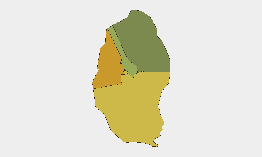
The Northern Governorate (risk score 72) and Southern Governorate (risk score 68) are the primary drivers of sub-national risk, reflecting a concentration of civil unrest, occupation events, and arrest activity. The Capital Governorate (score 45), which includes Manama and central government institutions, carries elevated but secondary risk. This geographic pattern suggests that domestic grievances—particularly around detention and judicial issues—are geographically clustered outside the capital, while the external Iranian threat is nationwide; security operations and duty-of-care protocols should reflect both the localized civil unrest and the diffuse external threat.
How GeoBit Would Assist
Intel Sweep and OSINT fusion would provide real-time corroboration of aerial-threat claims, interception success, and secondary threats via multi-language feeds and X/Telegram monitoring. AOI Monitoring and Early Warning with persistent watch on the Northern and Southern Governorates would flag occupation, arrest, and protest escalation before they impact business continuity or personnel safety. Conflict & Military mapping and alternative routing analysis would enable security teams to plan safe movements, avoid high-risk zones, and anticipate infrastructure closures or access restrictions tied to civil unrest or air-defense operations.
7-Day Outlook
Immediate risk of renewed Iranian aerial attack remains credible over the next 72 hours; precautionary shelter protocols and transport restrictions will likely persist. Domestic unrest in the Northern and Southern Governorates is unlikely to escalate dramatically but may produce localized disruptions (protests, access denial, personnel safety friction) that require real-time visibility and flexible contingency planning. Regional tension with Iran and Saudi Arabia suggests a volatile but not imminent further escalation; however, any new Iranian strikes would re-trigger nationwide alerts and disrupt normal operations.
Highest-Risk Areas — Ranked
| # | State / Region | Risk |
|---|---|---|
| 1 | Northern Governorate | 72 |
| 2 | Southern Governorate | 68 |
| 3 | Capital Governorate | 45 |
| 4 | Muharraq Governorate | 38 |
Sources
Previous Daily Briefs
A new Bahrain brief is written every day — each with its own risk map and downloadable CSV. Here's the last week; use the calendar to go further back.
📅 Browse every day by calendar →
Highlighted days have a brief. Tap a day for that day's map & analysis, or “csv” for that day's dataset ($5).
Atlas — our AI intelligence desk — emails them this snapshot personally. Nothing else, no list.