Situation Summary
Bangladesh faces a complex and volatile security environment marked by high-level political instability, intensified urban crime enforcement, and localized civil unrest. The assassination of the Prime Minister on 25 July and subsequent armed-forces involvement have triggered parliamentary statements and public responses, creating uncertainty around governance and institutional stability. Concurrent with political turbulence, police have launched large-scale anti-crime operations in Dhaka, border infiltration attempts persist, and heavy monsoon rainfall poses infrastructure risk across southern divisions. The country's composite threat score of 68 places it at #19 globally, with Dhaka Division substantially elevated at 77.2.
Key Developments
- Prime Minister Assassination (25 July) – Armed conflict between Prime Minister and Armed Forces reported; Parliament and national authorities issued statements on 25–26 July in response. Institutional and succession implications remain unclear.
- Dhaka Metropolitan Police Anti-Crime Operations (24–26 July) – DMP conducted two major 24-hour sweeps arresting 460 and 387 individuals respectively, with 49 and 45 criminal cases filed. Operations targeted drug trafficking (Uttara: 11,800 yaba tablets seized) and general crime across multiple neighborhoods, indicating heightened law-and-order activity amid broader instability.
- Border Infiltration Incident, Kushtia (early 26 July) – Border Guard Bangladesh intercepted attempted cross-border movement of eight unidentified individuals pushed by Indian BSF at Daulatpur border; group returned to Indian side. Reflects elevated border-security activity.
- Gas Explosion, Bhatara, Dhaka (26 July) – Residential gas-line leak caused fatal explosion killing a 24-year-old and 8-year-old child; one family member in critical condition. Highlights infrastructure vulnerability and localized safety hazard in central Dhaka.
- Administrative Protest, Fatikchhari, Chattogram (26 July) – 48-hour strike over upazila office location brought traffic on Feni–Khagrachhari regional highway and Gohira–Heyako road to near standstill; most shops closed. Localized but disruptive political dispute.
- Heavy Rainfall Alert, Southern Divisions (26 July) – Bangladesh Meteorological Department issued 24-hour severe weather warning for Khulna, Barishal, and Chattogram divisions; monsoon-driven heavy to very heavy rainfall poses flooding and landslide risk, with transport and infrastructure disruption expected.
Highest-Risk Areas
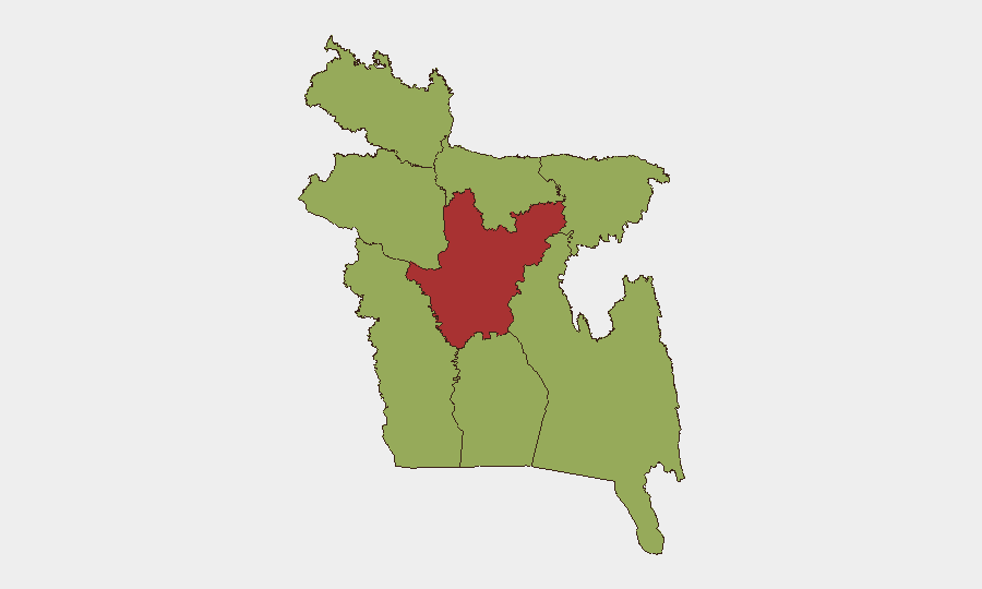
Dhaka Division dominates the risk landscape at 77.2, driven by the Prime Minister assassination, large-scale police operations, and dense urban infrastructure exposure. The remaining seven divisions cluster around 47–48, indicating more diffuse but persistent risk. Dhaka's elevation reflects both the political crisis and concurrent spike in organized crime enforcement, as well as critical infrastructure vulnerability (e.g., gas lines). Southern coastal divisions (Khulna, Barishal, Chattogram) face acute near-term risk from monsoon flooding and transport disruption, while border areas (Kushtia) show active cross-border security incidents.
How GeoBit Would Assist
Security teams should deploy AOI Monitoring & Early Warning on Dhaka Division and key infrastructure nodes (utilities, transport hubs) to detect cascading political or institutional disruption. Conflict & Military tracking would provide real-time force-structure and stability assessment around the armed forces and state institutions. Routing & Network Analysis supports contingency route planning for personnel and supply chains, particularly around monsoon-affected southern divisions and the Chattogram highway corridor.
7-Day Outlook
Political uncertainty will likely persist as institutional and succession mechanisms respond to the assassination. Security operations in Dhaka will probably continue, creating episodic arrest spikes and local friction. Heavy rainfall across the south (24–48 hours) will disrupt transport and commerce; personnel and asset movement in Khulna, Barishal, and Chattogram divisions should anticipate delays and infrastructure damage.
Highest-Risk Areas — Ranked
| # | State / Region | Risk |
|---|---|---|
| 1 | Dhaka Division | 77.2 |
| 2 | Mymensingh Division | 48.3 |
| 3 | Khulna Division | 47.4 |
| 4 | Rajshahi Division | 47.4 |
| 5 | Barishal Division | 47.2 |
| 6 | Chittagong Division | 47.2 |
| 7 | Rangpur Division | 47.2 |
| 8 | Sylhet Division | 47.2 |
Sources
Previous Daily Briefs
A new Bangladesh brief is written every day — each with its own risk map and downloadable CSV. Here's the last week; use the calendar to go further back.
📅 Browse every day by calendar →
Highlighted days have a brief. Tap a day for that day's map & analysis, or “csv” for that day's dataset ($5).
Atlas — our AI intelligence desk — emails them this snapshot personally. Nothing else, no list.