Situation Summary
Barbados remains in a low-threat security environment with a composite threat score of 3 globally and no validated incidents reported in the last 24–48 hours. Open-source monitoring as of 22 August 2026 confirms stable conditions across the island with no disruptions to critical infrastructure, travel, or business continuity. The security posture is characterized as calm and routine; no acute developments are evident that would elevate national risk.
Key Developments
No validated security, civil-unrest, infrastructure, or crime incidents have been reported in Barbados during the 24–48 hours preceding 24 August 2026. Open-source monitoring covering the period through 22 August indicates no spike in violent crime, political activity, protest mobilization, or service disruptions. Routine law-enforcement activity continues in multiple parishes, consistent with baseline policing; these do not constitute acute developments.
Note on data recency: Available open-source coverage extends reliably only to approximately 22 August 2026. Real-time incident confirmation for 23–24 August is not yet available in publicly indexed sources, but the pre-24 August trend is explicitly one of stability and low incident frequency.
Highest-Risk Areas
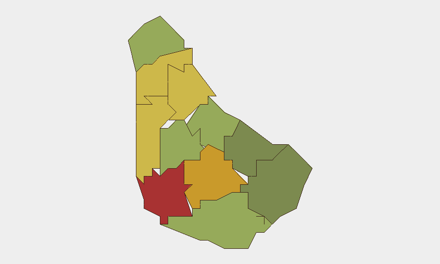
Saint Michael (risk 78) and Saint George (risk 72) drive the national risk profile and reflect urban density, commercial activity, and routine crime concentration typical of Barbados's capital and second-largest urban center. Saint James (risk 68) and Saint Andrew (risk 65) follow, forming a cluster of elevated but manageable parish-level risk. The southern and eastern parishes—Saint Philip (28), Saint John (35), and Christ Church (42)—register materially lower risk scores, consistent with lower population density and fewer commercial focal points. Risk rankings reflect structural factors (urbanization, economic activity, historical crime patterns) rather than acute incident escalation; no parish shows signs of destabilization.
How GeoBit Would Assist
Security teams with personnel or assets in Barbados can employ Intel Sweep and global event feeds to maintain real-time alerting on any emerging incidents across the island's parishes, with OSINT fusion & corroboration to validate reports before operational response. AOI Monitoring & Early Warning focused on Saint Michael, Saint George, and Saint James enables persistent watch over highest-risk zones with automated alerting should conditions shift. GIS & Spatial Analysis supports route planning and facility risk assessment in relation to crime and infrastructure data, enabling duty-of-care teams to optimize staff safety protocols and asset positioning.
7-Day Outlook
Barbados is forecast to remain in a stable, low-threat posture over the next seven days absent major exogenous shocks. Seasonal tourism and business patterns are expected to continue without disruption. Security teams should maintain routine monitoring and baseline awareness protocols; no escalatory trajectory is apparent.
Data Cutoff: Open-source validation through 22 August 2026. Real-time incident reports for 23–24 August not yet confirmed in indexed sources.
Highest-Risk Areas — Ranked
| # | State / Region | Risk |
|---|---|---|
| 1 | Saint Michael | 78 |
| 2 | Saint George | 72 |
| 3 | Saint James | 68 |
| 4 | Saint Andrew | 65 |
| 5 | Saint Peter | 62 |
| 6 | Saint Joseph | 58 |
| 7 | Saint Thomas | 52 |
| 8 | Saint Lucy | 48 |
| 9 | Christ Church | 42 |
| 10 | Saint John | 35 |
| 11 | Saint Philip | 28 |
Sources
Previous Daily Briefs
A new Barbados brief is written every day — each with its own risk map and downloadable CSV. Here's the last week; use the calendar to go further back.
- August 21, 2026
- August 18, 2026
- August 16, 2026
- August 14, 2026
- August 12, 2026
- August 10, 2026
- August 8, 2026
📅 Browse every day by calendar →
Highlighted days have a brief. Tap a day for that day's map & analysis, or “csv” for that day's dataset ($5).
Atlas — our AI intelligence desk — emails them this snapshot personally. Nothing else, no list.