Situation Summary
Belarus remains in a state of underlying political fragility and low-intensity security challenges, with composite threat levels moderate and stable over the current observation window. No major security, civil-unrest, or infrastructure incidents have been confirmed within Belarus proper during the last 24–48 hours. The primary external risk vectors involve ongoing Ukrainian military operations in adjacent Russian territory (Bryansk region), which affect Belarusian logistics networks and cross-border movement; internal threats remain concentrated in cyber-enabled fraud, routine criminal activity, and residual opposition-linked intelligence concerns. The security environment is best characterized as subdued but persistently monitored.
Key Developments
- Bryansk region, Russia (cross-border logistics risk) – Reporting indicates Ukrainian forces have conducted repeated attacks on civilian and freight transport linked to Belarusian operators within Russia's Bryansk region, including UAV strikes on Belarusian freight vehicles. Exact timing of the most recent incident is not clearly within the last 24–48 hours, but the pattern underscores elevated risk for Belarus-registered road cargo transiting Russian territory near the Ukraine border.
- Belarus Interior Ministry (nationwide cyber-fraud) – Police fielded approximately 470 reports of phone fraud and cyber-enabled scams over a recent 24-hour period, reflecting sustained high-volume low-level criminal activity. Publication timing of this report is recent but not definitively within the last 24–48 hours; the incident itself highlights vulnerability to organized cyber-fraud networks.
- Poland (external intelligence/counterterrorism cooperation) – Belarusian intelligence reportedly transmitted operational warning to Polish authorities regarding a planned attack targeting family members of opposition figure Sviatlana Tsikhanouskaya. While the underlying plot's date is unclear, this underscores ongoing transnational security liaison and threat activity linked to Belarusian opposition networks operating abroad.
- No confirmed domestic security incidents – Open-source corroboration for major unrest, protest activity, infrastructure disruption, or conflict-related events within Belarus during 24–48 hours ending August 6, 2026 is absent.
Highest-Risk Areas
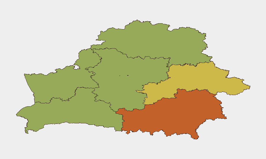
Homyel Region (south-central, bordering Ukraine and Russia) and Minsk (capital, administrative/economic hub) drive the composite risk ranking at 75 and 68 respectively. Homyel's elevation reflects proximity to active Ukrainian military operations in Russian border regions and historical vulnerability to cross-border spillover; Minsk concentrates political-opposition activity, intelligence operations, and state-security apparatus density. Mahilyow Region (east-central, 62) reflects similar border-proximity concerns. Peripheral regions—Vitsebsk (north, 45) and Minsk Region (surrounding capital, 48)—carry lower assessed risk, suggesting threat concentration in border zones and the capital itself.
How GeoBit Would Assist
Intel Sweep and X/Telegram OSINT paired with temporal analysis enable continuous monitoring of opposition networks, security-force activity, and cross-border incident reporting in real time. AOI Monitoring & Early Warning on Homyel Region, Minsk, and Bryansk-border areas provides persistent watch with threshold alerting for unrest, infrastructure disruption, or transport attacks affecting personnel or supply chains. Routing & Network Analysis supports alternative journey planning for staff and logistics operating in or transiting Belarus, avoiding highest-risk corridors during elevated threat windows.
7-Day Outlook
No significant escalation in domestic instability is indicated for the coming week. Transnational intelligence activity and cyber-fraud patterns are likely to persist at baseline levels. Border-region risks tied to Ukrainian operations in Russian territory will remain the primary external threat to Belarusian logistics and cross-border movement; monitoring of Bryansk-region targeting patterns is warranted to assess spillover risk to Belarusian operators.
Highest-Risk Areas — Ranked
| # | State / Region | Risk |
|---|---|---|
| 1 | Homyel Region | 75 |
| 2 | Minsk | 68 |
| 3 | Mahilyow Region | 62 |
| 4 | Brest Region | 55 |
| 5 | Hrodna Region | 52 |
| 6 | Minsk Region | 48 |
| 7 | Vitsebsk Region | 45 |
Sources
Previous Daily Briefs
A new Belarus brief is written every day — each with its own risk map and downloadable CSV. Here's the last week; use the calendar to go further back.
📅 Browse every day by calendar →
Highlighted days have a brief. Tap a day for that day's map & analysis, or “csv” for that day's dataset ($5).
Atlas — our AI intelligence desk — emails them this snapshot personally. Nothing else, no list.