Situation Summary
Belize remains a moderately elevated crime and gang environment, ranked #105 globally with gang/criminal activity as the primary threat driver. The past week saw at least three fatal shootings in Belize City, continuing a pattern of lethal street violence concentrated in the country's most urbanized district. A separate Sarstoon River maritime incident involving Guatemalan vessels on 2026-09-10 underscores ongoing territorial friction but does not yet reflect escalation. Overall trajectory remains elevated but stable.
Key Developments
- Belize City, Louise Bevans Street – 2026-09-16: 20-year-old Anthony William Perry shot and killed; no arrests reported at time of incident notification.
- Belize City, Terrylee Crawford Street/Faber's Road area – 2026-09-17: 43-year-old Honduran national Dennis Perdomo Guevara fatally shot; police responded and investigated.
- Belize City, T Street area – 2026-09-09: Jaheim Sanchez shot and killed in incident attributed to ongoing local rivalry; a second victim suffered grazing wound and received treatment.
- Sarstoon River/Sarstoon Island – 2026-09-10: Belizean authorities protested Guatemalan military and civilian vessel incursion into Belizean waters and obstruction of customary Belizean navigation around the island; Guatemalan ambassador subsequently summoned by the government.
Highest-Risk Areas
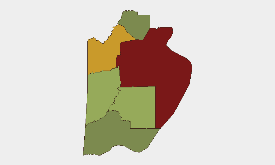
Belize District (risk score 95) dominates the threat landscape, with concentrated homicidal violence in Belize City's gang-affiliated neighborhoods. Orange Walk District (72) and Cayo District (58) present secondary risks linked to trafficking corridors and organized crime networks active since February 2026 and earlier. Southern districts—Stann Creek (48) and Toledo (35)—carry lower but persistent risk; Corozal District (22) remains the lowest-risk jurisdiction. Urban gang rivalry and cross-border criminal movement explain the geographic concentration in the north-central corridor and capital.
How GeoBit Would Assist
Organizations with personnel or assets in Belize should employ AOI Monitoring & Early Warning to track high-risk neighborhoods in Belize City and Orange Walk for emerging violence signals, supported by OSINT fusion & corroboration (X/Telegram feeds, local news, police releases) to detect threats in near-real time. Routing & Network Analysis can generate safer travel corridors for staff within Belize City and between districts, while GIS & Spatial Analysis overlays gang territory, recent homicide clusters, and maritime boundary disputes to inform duty-of-care decisions. Risk & Threat Assessment capabilities contextualize district-level trends for specific company operations.
7-Day Outlook
Street homicides in Belize City are likely to persist at current levels absent unexpected police operations or gang truce activity. The Sarstoon maritime incident remains a diplomatic issue but carries low near-term escalation risk. Organizations should maintain standard heightened awareness in Belize District and reinforce travel/movement protocols; no system-wide emergency is anticipated over the next seven days.
Highest-Risk Areas — Ranked
| # | State / Region | Risk |
|---|---|---|
| 1 | Belize District | 95 |
| 2 | Orange Walk District | 72 |
| 3 | Cayo District | 58 |
| 4 | Stann Creek District | 48 |
| 5 | Toledo District | 35 |
| 6 | Corozal District | 22 |
Sources
Previous Weekly Briefs
A new Belize brief is written every Monday, covering the week — each with its own risk map and downloadable CSV. Use the calendar to go further back.
- September 14, 2026
- September 7, 2026
- September 1, 2026
- August 30, 2026
- August 27, 2026
- August 25, 2026
- August 23, 2026
📅 Browse past briefs by calendar →
Highlighted days have a brief. Tap a day for that day's map & analysis, or “csv” for that day's dataset ($5).
Atlas — our AI intelligence desk — emails them this snapshot personally. Nothing else, no list.