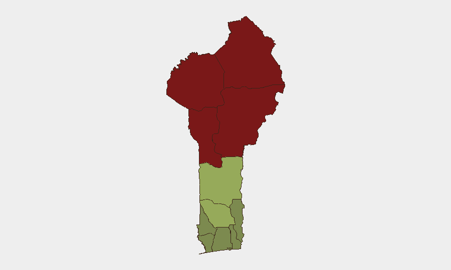
Situation Summary
Benin remains a relatively stable West African state (global threat rank #49) but faces persistent security challenges concentrated in its northern departments, where jihadist activity, transnational smuggling, and cross-border incursions drive elevated risk. The country's southern and coastal zones—home to most economic activity and foreign personnel—maintain significantly lower threat profiles. Recent signals suggest ministerial and official statements on 12 July, including a public statement from Nigeria, but specific incident details and operational impacts remain unclear pending verification.
Key Developments
GeoBit's current web research does not confirm discrete security, conflict, crime, or infrastructure incidents in Benin from 12 July or the preceding 24–48 hours with sufficient geo-specificity and cross-source confidence to warrant operational alert. Three signals are flagged for investigation (ministerial statement, Benin government statement, Nigerian government statement, all 12 July), but underlying event details—incident location, nature, and timing—are not yet publicly detailed in available feeds.
Recommended action: Security teams should monitor official Benin government communications and Nigerian border-related statements on 12–13 July to clarify whether signals relate to border management, internal governance, or cross-border security coordination.
Highest-Risk Areas
Northern Benin—Alibori (risk 92), Atakora (88), Donga (85), and Borgou (83) departments—dominates the threat landscape and reflects sustained jihadist presence, trafficking networks, and porous borders with Niger and Burkina Faso. These zones experience sporadic armed-group activity, kidnapping risk, and counter-terrorism operations; road travel is hazardous and visibility into security incidents is limited. By contrast, central and southern departments (Zou, Collines, Plateau, Kouffo) present moderate residual risk, while coastal and urban centers (Littoral, Ouémé, Atlantique) remain the safest zones for business and expatriate presence. Risk concentration in the north reflects the broader Sahel insurgency dynamic; southern stability reflects government control and economic integration.
How GeoBit Would Assist
Security teams in Benin should deploy AOI Monitoring & Early Warning on northern departments (Alibori, Atakora, Borgou, Donga) to detect armed-group movements, roadblocks, and incident clusters in near-real time. Intel Sweep combined with multi-language OSINT (French, local radio, Telegram/X feeds) and ACLED/INSO conflict feeds will flag battles, protests, and crime events within hours of occurrence. Routing & Network Analysis enables duty-of-care teams to model alternative routes and safe-passage windows around northern operations; entity and network mapping tracks smuggling and trafficking nodes affecting border stability and supply-chain risk.
7-Day Outlook
The 12 July ministerial and government statements warrant clarification by 13–14 July; if they signal coordinated cross-border or counter-terrorism action, northern risk may spike temporarily. Absent major incident escalation, Benin's threat trajectory remains stable at baseline levels: northern zones retain chronic low-intensity risk; southern and coastal areas remain open for operations. Monitoring should remain vigilant for any spillover from Nigerian security operations or Sahel-wide jihadist activity.
Highest-Risk Areas — Ranked
| # | State / Region | Risk |
|---|---|---|
| 1 | Alibori Department | 92 |
| 2 | Atakora Department | 88 |
| 3 | Donga Department | 85 |
| 4 | Borgou Department | 83 |
| 5 | Zou Department | 45 |
| 6 | Collines Department | 42 |
| 7 | Plateau Department | 38 |
| 8 | Kouffo Department | 35 |
| 9 | Mono Department | 32 |
| 10 | Atlantique Department | 28 |
| 11 | Littoral | 25 |
| 12 | Ouémé Department | 22 |
Sources
Previous Daily Briefs
A new Benin brief is written every day — each with its own risk map and downloadable CSV. Here's the last week; use the calendar to go further back.
📅 Browse every day by calendar →
Highlighted days have a brief. Tap a day for that day's map & analysis, or “csv” for that day's dataset ($5).
Atlas — our AI intelligence desk — emails them this snapshot personally. Nothing else, no list.