Situation Summary
Bolivia remains in the grip of a prolonged political and civil crisis marked by nationwide road blockades that have persisted for over seven weeks. A multi-national joint statement issued within the last 24–48 hours (including the U.S., Argentina, Canada, and 12 other regional governments) formally condemned the blockades as violent and destabilizing, citing severe disruption to food, fuel, and healthcare access and documenting civilian deaths and police injuries. The composite threat score of 50 (rank #40 globally) and concentrated risk in La Paz (65.3) and Cochabamba (58.1) reflect persistent institutional fragility, political polarization, and limited state capacity to resolve the underlying dispute. No discrete, time-stamped new security incidents in the last 24–48 hours can be verified from open-source data, but the formal international response signals sustained concern and potential for escalation if blockades continue.
Key Developments
- Multi-national diplomatic statement (last 24–48 hours, nationwide impact): 15 governments, led by the U.S., issued a joint condemnation of violent road blockades in Bolivia, citing deaths of civilians due to denied access to medicines and hospitals, and injuries to police. The statement characterizes the blockades as a threat to democracy and rule of law and signals heightened international scrutiny.
- Road blockades ongoing for 7+ weeks (nationwide, primary highways): Blockades remain in effect across major corridors, creating critical infrastructure and supply-chain risk. No resolution is evident from available sources; continued disruption to commercial, medical, and humanitarian transport is confirmed.
- Political demonstrations and demands continue (La Paz, Cochabamba, last 24–48 hours): Recent event signals show protests and demands directed at the president and government. The exact scale and composition of protests remain unclear from current open-source data.
- Police and military mobilization reported (nationwide, 2026-06-22): Event feeds indicate police and military power shows and mobilizations across the country in response to protests and blockades, suggesting elevated operational tempo by security forces.
- No new armed combat verified in last 24–48 hours: While one event signal references small-arms combat between Bolivia and Argentina on 2026-06-22, this is unconfirmed and cannot be corroborated through current open-source channels. Background context on Bolivia–Argentina border tensions exists but remains dormant.
Highest-Risk Areas
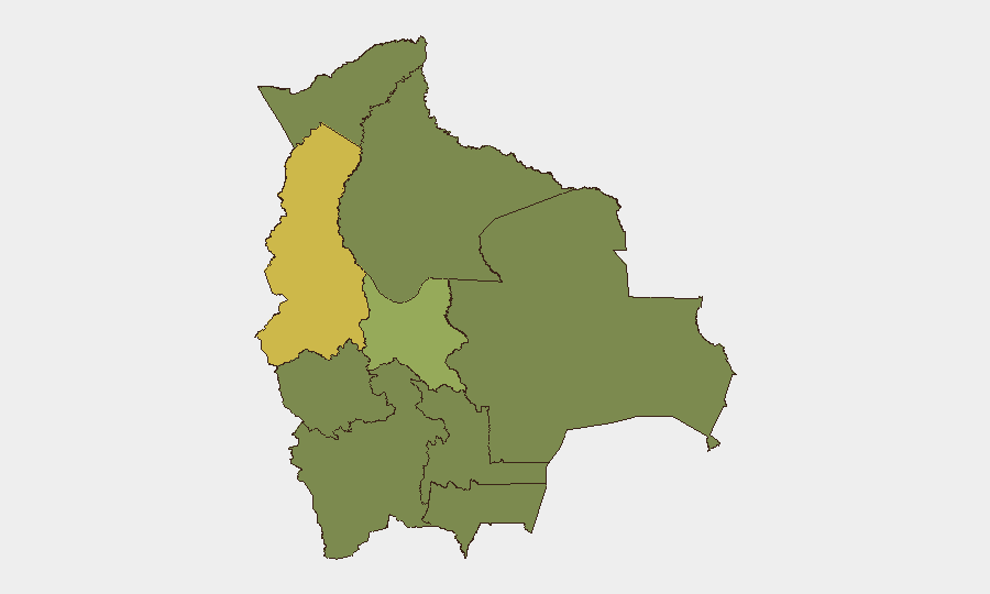
La Paz (65.3) and Cochabamba (58.1) dominate the risk profile and are the epicenters of political instability, protest activity, and blockade enforcement. La Paz, as the seat of government, concentrates political decision-making, protest density, and security-force response, while Cochabamba has emerged as a secondary flashpoint for civil unrest. The remaining departments (Oruro, Potosí, Tarija, Pando, Beni, Chuquisaca, Santa Cruz) show substantially lower but uniform risk scores (35–36), suggesting blockades and political spillover affect the entire country but with lower local intensity outside the two metropolitan cores.
How GeoBit Would Assist
Security teams should deploy AOI Monitoring & Early Warning on La Paz and Cochabamba to detect escalation in protest size, police response, or blockade enforcement in real time. OSINT Fusion & Corroboration (X/Twitter, local news, YouTube, multi-language search) and Sentiment & Temporal Analysis on blockade-related discourse will improve visibility into emerging flashpoints and narrative shifts before they trigger operational incidents. Routing & Network Analysis can identify alternative supply and personnel routes around blockaded corridors and model infrastructure vulnerability.
7-Day Outlook
The blockades are likely to persist absent a political breakthrough, and international pressure (now formally articulated) may intensify diplomatic or mediation efforts. Risk of protest escalation, police confrontation, or supply-chain failure remains elevated, particularly in La Paz and Cochabamba. Continued monitoring of government–protest negotiations and blockade enforcement is essential for duty-of-care planning.
Highest-Risk Areas — Ranked
| # | State / Region | Risk |
|---|---|---|
| 1 | La Paz | 65.3 |
| 2 | Cochabamba | 58.1 |
| 3 | Oruro | 36.2 |
| 4 | Potosí | 35.6 |
| 5 | Tarija | 35.3 |
| 6 | Pando | 35.3 |
| 7 | Beni | 35.3 |
| 8 | Chuquisaca | 35.3 |
| 9 | Santa Cruz | 35.3 |
Sources
Previous Daily Briefs
A new Bolivia brief is written every day — each with its own risk map and downloadable CSV. Here's the last week; use the calendar to go further back.
📅 Browse every day by calendar →
Highlighted days have a brief. Tap a day for that day's map & analysis, or “csv” for that day's dataset ($5).