Situation Summary
Bulgaria remains a low-threat environment globally (composite score 6; #159 ranking), with no discrete security events in the current tracking window. However, the past 48 hours have seen a cluster of localized incidents—GPS jamming, severe weather, wildfire activity, traffic accident, and minor vandalism—concentrated in Sofia and select provincial centers. These developments do not signal systemic instability but reflect routine operational hazards and environmental pressures typical of late summer in the region.
Key Developments
- Sofia, Dragalevtsi district (24 Aug 2026): State Agency for National Security located and neutralized a powerful GPS signal jammer affecting Sofia Airport and aircraft operations. Transport Ministry confirmed no compromise to flight safety and characterized the response as appropriate.
- Sofia citywide (24 Aug 2026): Severe thunderstorm with heavy hail caused localized flooding and at least 11 fallen trees across central districts (Druzhba, Ovcha Kupel, Lyulin) and surrounding areas.
- Bezmer Air Base, Yambol region (23 Aug 2026, reported 24 Aug): Two U.S. Air Force KC-135 tanker aircraft departed after temporary deployment. Defence Minister stated all flights were training missions over allied territory with no direct threat to Bulgarian security.
- Sliven region, between Gradets and Medven (23 Aug 2026): Police detained two suspects in connection with large-scale arson destroying approximately 2,000 acres of low vegetation. Ministry of Interior reported situation calm with no ongoing outbreak danger.
- Trakia motorway (AM Trakiya) near Bulgarovo, Burgas region (night of 23–24 Aug 2026): Serious traffic collision with heavy vehicle damage reported; casualty and injury status unconfirmed at time of reporting.
- Sofia, Paradise Mall area, Cherni Vrah Boulevard (night of 23 Aug 2026): Two juveniles (approx. 13–15 years old) damaged a vehicle by throwing concrete at the windshield around 22:30. No physical injuries; victim filed police complaint.
- Countrywide (through 23 Aug 2026): Ministry of Interior reported 140 fires extinguished in a 24-hour period with two citizens injured, indicating elevated wildfire pressure across the country.
Highest-Risk Areas
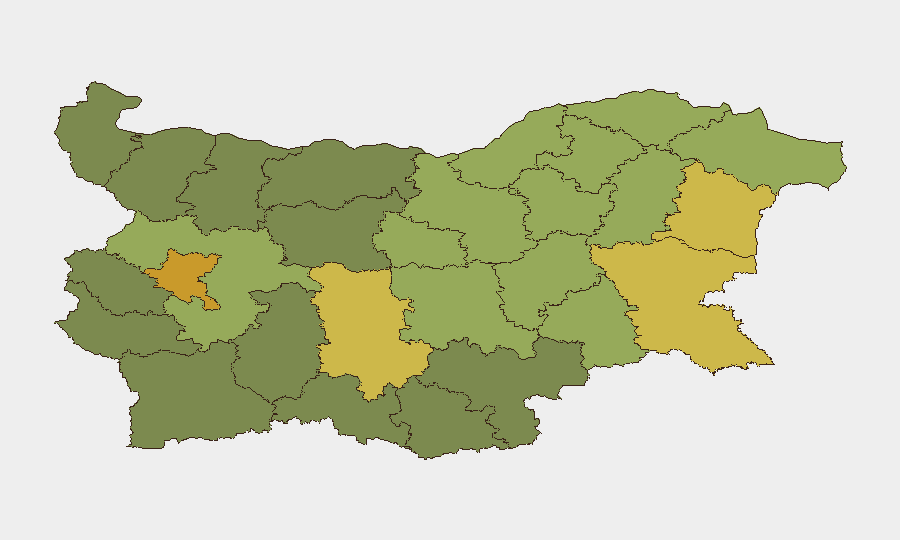
Sofia-City (risk 72) and Plovdiv (risk 68) drive the highest sub-national risk scores, followed by coastal centers Varna (65) and Burgas (62). Sofia-City's elevation reflects urban density, infrastructure concentration, and proximity to critical nodes (airport, government); the city has hosted the GPS jamming incident and severe weather damage. Plovdiv's position reflects similar urban-center dynamics. Provincial regions (Sliven, Ruse, Stara Zagora) show moderate elevated risk linked to wildfire activity and isolated incidents rather than systemic security threats. Risk scores remain in the low-to-moderate range globally.
How GeoBit Would Assist
Intel Sweep and OSINT fusion enable continuous monitoring of Bulgarian security and safety developments across local media, social platforms, and official statements—critical for identifying emerging patterns in wildfire activity, infrastructure incidents, or civil unrest. AOI Monitoring & Early Warning on Sofia, Plovdiv, and other high-risk urban centers allows organizations to receive alerts on localized traffic incidents, weather events, and security developments affecting staff safety or asset movement. Routing & Network Analysis supports real-time alternative journey planning for personnel and logistics around incident zones (e.g., motorway collisions, storm-affected districts), reducing exposure during high-activity periods.
7-Day Outlook
Wildfire activity is likely to remain elevated given August weather patterns and the 140 fires extinguished in a single day; organizations with assets in rural or forested regions should maintain situational awareness. Urban centers will continue to experience typical summer weather and traffic hazards. No indication of escalating security threats or civil unrest; the threat environment is expected to remain consistent with the current low-risk baseline.
Highest-Risk Areas — Ranked
| # | State / Region | Risk |
|---|---|---|
| 1 | Sofia-City | 72 |
| 2 | Plovdiv | 68 |
| 3 | Varna | 65 |
| 4 | Burgas | 62 |
| 5 | Sofia | 58 |
| 6 | Ruse | 55 |
| 7 | Stara Zagora | 52 |
| 8 | Sliven | 50 |
| 9 | Shumen | 48 |
| 10 | Razgrad | 47 |
| 11 | Yambol | 45 |
| 12 | Dobrich | 44 |
Sources
Previous Daily Briefs
A new Bulgaria brief is written every day — each with its own risk map and downloadable CSV. Here's the last week; use the calendar to go further back.
- August 22, 2026
- August 20, 2026
- August 18, 2026
- August 16, 2026
- August 14, 2026
- August 12, 2026
- August 10, 2026
📅 Browse every day by calendar →
Highlighted days have a brief. Tap a day for that day's map & analysis, or “csv” for that day's dataset ($5).
Atlas — our AI intelligence desk — emails them this snapshot personally. Nothing else, no list.