Situation Summary
Burkina Faso remains in a persistently elevated threat environment (composite ranking #22 globally, score 92/100) driven by active jihadist and armed-group operations across northern and central regions. Over the last 24–48 hours, no location-specific kinetic incidents or civil-unrest events have been confirmed by open-source security monitoring; however, the absence of reported discrete events does not indicate operational pause by insurgent groups. Ongoing multi-region counter-insurgency operations and recent diplomatic ruptures (full break with France, EU official expulsions) continue to frame the operating environment as volatile and resource-constrained.
Key Developments
- No discrete, location-verified security incidents reported in the last 24–48 hours across Burkina Faso; open-source security briefs (dated 15–16 July 2026) explicitly note absence of geolocated kinetic attacks or unrest events, though threat levels remain structurally high.
- Benin–Burkina Faso border patrol operations ongoing (signaled 13–14 July): joint cross-border counter-insurgency activity targeting militant movement in frontier zones; no specific clashes confirmed in the last 48 hours, but activity indicates sustained pressure on insurgent transit routes.
- Multi-region counter-insurgency operations aggregated to early July 2026: security-force operations cited in mid-July reporting (dozens of militants killed, several bases destroyed) are timestamped to the first two weeks of July; specific timing and location confirmation for events within 16–18 July are not available in current open-source feeds.
- Diplomatic escalation context (mid-July): Burkina Faso's rupture with France and expulsion of EU officials (late June into July) persist as backdrop to overall instability; these do not constitute discrete security incidents but reflect political fragmentation that constrains humanitarian access and security-force coordination.
- Heightened GEOBIT event-signal activity (17–18 July): government and actor-level statements, disapproval, and threats flagged in GEOBIT feeds on 17–18 July warrant monitoring for policy or posture shifts; content and attribution details require real-time platform review.
Highest-Risk Areas
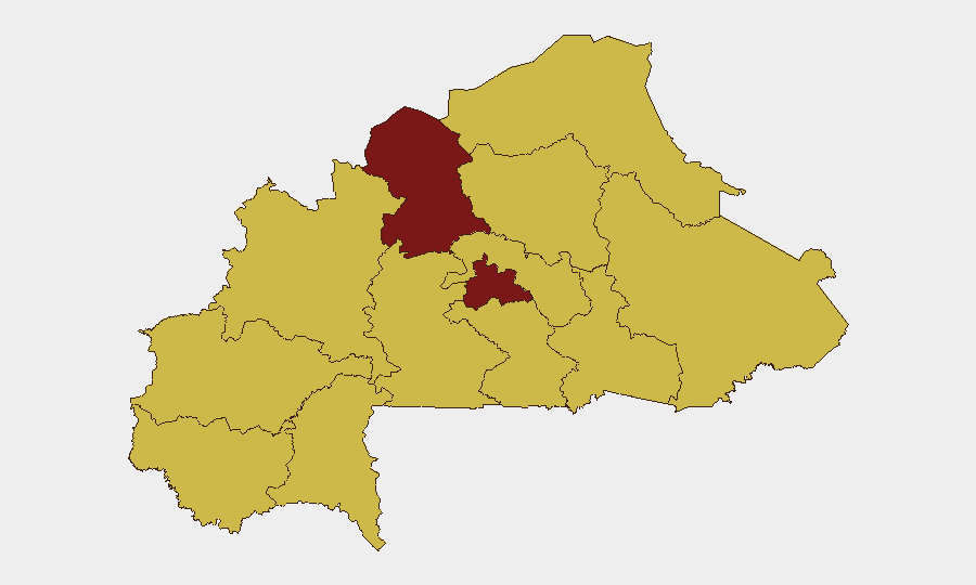
The North region (risk score 94.5) and Centre (84.5) together account for the majority of confirmed and ongoing insurgent activity, driven by presence of jihadist cells, armed-group splinter units, and limited state security-force density. The Upper-Basins, Boucle du Mouhoun, Central-West, Central-South, Central-East, Sahel, and East regions (all 64.5) form a secondary tier of sustained risk, reflecting geographic dispersal of armed networks and porous borders facilitating cross-frontier operations. Northern and central zones are primary targets for armed-group recruitment, IED deployment, and supply-line disruption; commercial, humanitarian, and government operations in these regions face elevated exposure to ambush, checkpoint harassment, and indirect fire.
How GeoBit Would Assist
Security teams should deploy AOI (Area-of-Interest) Monitoring & Early Warning on high-risk zones (North, Centre, border areas) to surface newly emerging, geolocated incidents with sub-24-hour latency. Intel Sweep, OSINT fusion, and multi-language event feeds enable duty-of-care teams to track diplomatic signals and threat-actor statements in real time, anticipating policy shifts that affect access, movement, and partner coordination. GIS & Spatial Analysis and alternative Routing & Network Analysis support travel-risk mitigation by identifying secure corridors and operational windows around confirmed incident clusters.
7-Day Outlook
No imminent escalation or localized flashpoint has emerged in the last 48 hours; however, the combination of high ambient threat, active counter-insurgency operations, and diplomatic isolation creates sustained risk for secondary cascades (checkpoints, supply-line disruptions, administrative friction). Continued monitoring of border zones and multi-region operation tempo is essential; security teams should maintain heightened alert posture for 72–168-hour incident correlation and early-warning signal capture.
Highest-Risk Areas — Ranked
| # | State / Region | Risk |
|---|---|---|
| 1 | North | 94.5 |
| 2 | Centre | 84.5 |
| 3 | Upper-Basins | 64.5 |
| 4 | Boucle du Mouhoun | 64.5 |
| 5 | Central-West | 64.5 |
| 6 | Central-South | 64.5 |
| 7 | Central-East | 64.5 |
| 8 | Waterfalls | 64.5 |
| 9 | Southwest | 64.5 |
| 10 | Sahel | 64.5 |
| 11 | Central-North | 64.5 |
| 12 | East | 64.5 |
Sources
Previous Daily Briefs
A new Burkina Faso brief is written every day — each with its own risk map and downloadable CSV. Here's the last week; use the calendar to go further back.
📅 Browse every day by calendar →
Highlighted days have a brief. Tap a day for that day's map & analysis, or “csv” for that day's dataset ($5).
Atlas — our AI intelligence desk — emails them this snapshot personally. Nothing else, no list.