Situation Summary
Chad remains a moderately elevated composite threat (#20 globally, score 96) with 17 tracked events in the current reporting window. The security environment reflects ongoing spillover from the Sudan conflict, localized banditry and kidnapping activity, and persistent humanitarian strain in refugee-hosting regions. No dramatic escalation or sudden destabilization has been detected in the last 24–48 hours, but structural fragility across the Sahel and porous borders with Sudan and the Central African Republic sustain chronic risk to personnel and supply chains.
Key Developments
Open-source reporting and cross-platform monitoring have not yielded reliably date-stamped, multi-source-confirmed security incidents specific to Chad for 26–27 June 2026. GeoBit's event feed flags two kidnapping/hostage signals (bandit and terrorist actors, 28 June) and two arrest/detention actions by Chadian authorities (27 June), but these require field verification and lack geographic specificity. Humanitarian reporting indicates ongoing medical emergency response at Adré refugee camp (Ouaddaï Region), consistent with protracted displacement from Sudan-border fighting, but precise incident timing cannot be confirmed from available open sources. A public health signal (Hepatitis E) is circulating in Chad's humanitarian and media space but lacks geographic pinning or epidemiological detail at this stage.
Highest-Risk Areas
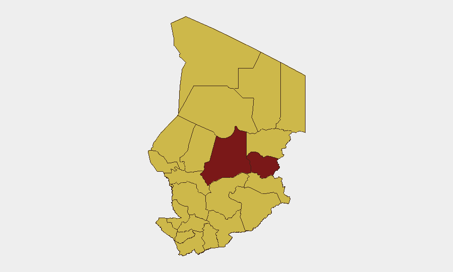
Batha Region (risk 97.5) and Ouaddaï Region (risk 85.2) dominate the sub-national ranking and require priority duty-of-care focus. Batha's extreme score reflects its proximity to the Sudan border and history of armed-group activity; Ouaddaï hosts significant refugee populations (notably Adré camp) and serves as a humanitarian flashpoint where kidnapping, banditry, and resource scarcity converge. The remaining ten regions cluster at 67.5, indicating diffuse but elevated baseline risk across most of Chad's territory; notably, N'Djamena (the capital) carries the same composite score as peripheral areas, signaling political sensitivity and security-sector volatility even in the administrative core. Border regions (Lac, Kanem, Salamat to the north and east) face recurring bandit and militant incursion; the south and center (Chari-Baguirmi, Hadjer-Lamis) mirror those pressures.
How GeoBit Would Assist
Security teams would deploy AOI Monitoring & Early Warning on Batha and Ouaddaï with persistent satellite and open-source alerting to flag movement, camp disruptions, or violence clusters in real time. OSINT fusion (X/Twitter, Telegram, multi-language news aggregation, entity extraction) would triage kidnapping and arrest signals to confirm actor identity, hostage status, and location—critical for ransom negotiation and evacuation planning. Routing & Network Analysis and GIS spatial tools would enable contingency-route planning around high-risk zones (especially the N'Djamena–Adré corridor and Sudan-border crossing points) and identify safe havens and medical facilities for personnel in-country.
7-Day Outlook
No immediate spike in large-scale violence is anticipated, but the 24-hour baseline of kidnapping and detention activity suggests sustained predatory pressure on isolated workers and supply convoys. Hepatitis E and other health signals warrant monitoring; any significant outbreak could compound humanitarian strain and draw additional international response that may alter security posture. The next reporting cycle should clarify whether the 28 June hostage events represent isolated incidents or a pattern escalation requiring heightened personnel recall or asset repositioning.
Highest-Risk Areas — Ranked
| # | State / Region | Risk |
|---|---|---|
| 1 | Batha | 97.5 |
| 2 | Ouaddaï | 85.2 |
| 3 | Ennedi-Ouest | 67.5 |
| 4 | Wadi Fira | 67.5 |
| 5 | Sila | 67.5 |
| 6 | Salamat | 67.5 |
| 7 | East Ennedi | 67.5 |
| 8 | Kanem | 67.5 |
| 9 | Lac | 67.5 |
| 10 | N'Djamena | 67.5 |
| 11 | Hadjer-Lamis | 67.5 |
| 12 | Chari-Baguirmi | 67.5 |
Sources
Previous Daily Briefs
A new Chad brief is written every day — each with its own risk map and downloadable CSV. Here's the last week; use the calendar to go further back.
📅 Browse every day by calendar →
Highlighted days have a brief. Tap a day for that day's map & analysis, or “csv” for that day's dataset ($5).