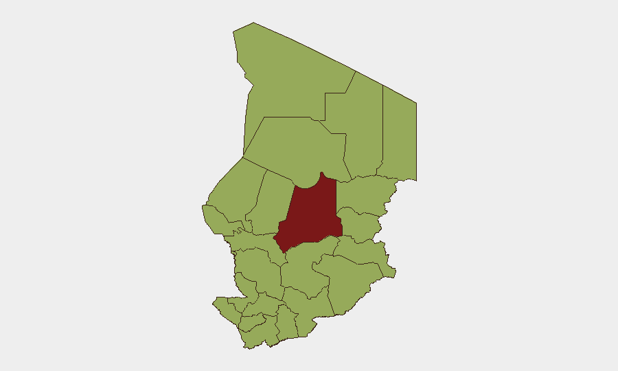
Situation Summary
Chad remains a complex operating environment with a composite threat score of 74 (rank #29 globally) driven by persistent banditry, terrorist activity, and state detention operations. The past 72 hours have recorded multiple abduction events—both bandit and terrorist-attributed—alongside worker extortion demands and police arrest activity, indicating active criminal and militant pressure across the country. Hepatitis E circulation compounds health risk. The security posture is neither improving nor deteriorating sharply, but remains elevated with meaningful risk concentration in the Sahel-adjacent northern and eastern regions.
Key Developments
- 2026-06-28 · Bandit Abduction/Hijacking Event — Precise location not confirmed in available data; bandit actors conducted abduction/hijacking incident against unspecified target.
- 2026-06-28 · Terrorist Abduction/Hostage Event — Terrorist-attributed abduction or hostage-taking reported; location and target profile pending corroboration.
- 2026-06-27 · State Arrest Operations (×2) — Chadian authorities conducted arrests in criminal and non-criminal categories; specific locations and charges not specified in current intelligence.
- 2026-06-26 · Worker Extortion Demand — Demand made against worker or worker cohort; location, sector, and threat actor not yet detailed.
- 2026-06-26 · State Threat Activity — Chadian state apparatus issued threat(s); context and target not yet clarified.
- Health Alert: Hepatitis E Circulation — Hepatitis E confirmed in circulation within Chad; no spatial or temporal specificity available, but relevant for duty-of-care personnel health protocols.
*Note: Web research for 24–48 hour incident confirmation has not yielded additional corroborated developments. Team should cross-reference X, international NGO alerts, and regional news wires for real-time updates.*
Highest-Risk Areas
Batha province (81.7) stands isolated as the highest-risk sub-national area, likely driven by bandit activity, illicit movement, and/or militant presence in a sparsely governed Sahel zone. Nine other regions—Ennedi-Ouest, Wadi Fira, Ouaddaï, Sila, Salamat, East Ennedi, Kanem, Lac, and Hadjer-Lamis—cluster at 51.7 risk score, all exceeding N'Djamena (51.7), indicating that remote northern and eastern border zones face systematically higher threat density than the capital. This pattern reflects traditional bandit/militant sanctuaries, weak state presence, and cross-border movement corridors. N'Djamena's equivalent score to outer regions reflects elevated urban crime, state security operations, and transactional crime despite capital-city governance infrastructure.
How GeoBit Would Assist
Corporate security teams should deploy AOI (Area-of-Interest) Monitoring & Early Warning on Batha and eastern border zones to receive alerts on emerging incidents before they affect operations. Network & Actor Analysis and OSINT fusion (X/Telegram, radio SIGINT, event feeds) would rapidly identify which bandit or militant cells are responsible for abductions, enabling risk-adjusted routing and personnel scheduling. Routing & Network Analysis capabilities allow security planners to model alternative routes and safe corridors around high-risk provinces, while Conflict & Military mapping clarifies territorial control and force postures in remote areas where state authority is contested.
7-Day Outlook
No imminent major escalation is signaled by current event frequency or messaging tone, but bandit and terrorist abduction activity remains operationally active. Personnel in Batha, border regions, and remote eastern provinces face persistent transit and site-specific risks over the next week. Security teams should maintain heightened posture on worker movements, verify health protocols for Hepatitis E exposure, and prepare contingency evacuation routes.
Highest-Risk Areas — Ranked
| # | State / Region | Risk |
|---|---|---|
| 1 | Batha | 81.7 |
| 2 | Ennedi-Ouest | 51.7 |
| 3 | Wadi Fira | 51.7 |
| 4 | Ouaddaï | 51.7 |
| 5 | Sila | 51.7 |
| 6 | Salamat | 51.7 |
| 7 | East Ennedi | 51.7 |
| 8 | Kanem | 51.7 |
| 9 | Lac | 51.7 |
| 10 | N'Djamena | 51.7 |
| 11 | Hadjer-Lamis | 51.7 |
| 12 | Chari-Baguirmi | 51.7 |
Sources
Previous Daily Briefs
A new Chad brief is written every day — each with its own risk map and downloadable CSV. Here's the last week; use the calendar to go further back.
📅 Browse every day by calendar →
Highlighted days have a brief. Tap a day for that day's map & analysis, or “csv” for that day's dataset ($5).