Situation Summary
Colombia remains at global threat rank #17 (composite score 74), driven primarily by insurgency and criminal armed violence across 396 tracked events. The country faces persistent pressure from armed group activity, Venezuelan irregular migration flows, and enforcement of electoral-period security measures. Current posture reflects heightened state response to border incursions and organized armed activity, particularly in frontier departments. The security environment shows no sign of material de-escalation over the next 7 days.
Key Developments
- Villa del Rosario (Juan Frío sector), Norte de Santander – 22 June 2026: Joint Policía Nacional, Ejército, Procuraduría, and Personería operation interdicted an irregular crossing attempt from Venezuela; forces halted a group attempting to enter Colombia via unauthorized "trocha" routes near the Cúcuta metropolitan area.
- Cúcuta metropolitan border zone, Norte de Santander – 22 June 2026: Following the Juan Frío incident, security forces implemented heightened border enforcement posture, including dedicated Army patrols of non-authorized crossing points between Venezuela and Colombia to prevent mass irregular entry during the current electoral period.
- Norte de Santander–Venezuela border corridor – ongoing: Presidential decree on border transit control during elections remains in effect; coordination between military, police, and civil authority agencies indicates sustained, multi-agency enforcement at frontier crossing points.
- Multiple armed group vs. military engagements – 22 June 2026: Two separate conventional military force incidents involving armed groups and military forces were recorded on 22 June; specific locations and casualty figures remain unreported in available open-source channels.
- Barranquilla municipal-level political friction – 22 June 2026: Public statement issued by Barranquilla authorities in tension with national presidential position; nature of dispute not yet clarified in reporting; potential for local governance friction during election period.
Highest-Risk Areas
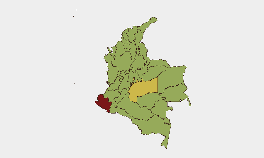
Nariño Department (81.8) stands as Colombia's single highest-risk sub-national zone, likely driven by cross-border illicit activity, Venezuelan spillover effects, and established armed group territorial control. The Capital District (61.3) and Meta Department (60.3) rank second and third, reflecting urban security challenges, criminal enterprise concentration, and rural insurgent presence respectively. Norte de Santander (54.7) and Santander (56.3) show elevated risk tied to Venezuelan border dynamics—as demonstrated by today's irregular crossing activity—combined with coca cultivation, trafficking corridors, and armed group recruitment. Together, the top five departments account for the bulk of tracked security events and represent the geographic priority for corporate duty-of-care planning.
How GeoBit Would Assist
Security teams operating in Colombia should employ AOI Monitoring & Early Warning on Nariño, Norte de Santander, and Capital District to receive real-time alerts on armed group movement, military mobilization, and border incursions. Intel Sweep and multi-language OSINT fusion across regional media, X/Twitter, and Telegram sources enable rapid corroboration of emerging incidents and localization of threat clusters. GIS & Spatial Analysis and Routing & Network Analysis support alternative journey planning and site-security assessment in high-risk departments, while Network & Actor Analysis maps criminal and insurgent organizational structure to support risk assessment of specific personnel placements.
7-Day Outlook
Electoral-period border enforcement is expected to remain elevated across the Venezuela-Colombia frontier, with continued joint-force operations in Norte de Santander and Nariño. Armed group activity in rural Meta, Cauca, and Antioquia departments will likely persist at current operational tempos. No major deescalatory signals are evident; risk of secondary irregular migration attempts and armed clashes should be assumed as baseline through end of June.
Highest-Risk Areas — Ranked
| # | State / Region | Risk |
|---|---|---|
| 1 | Nariño | 81.8 |
| 2 | Capital District | 61.3 |
| 3 | Meta Department | 60.3 |
| 4 | Cauca | 56.8 |
| 5 | Santander Department | 56.3 |
| 6 | Antioquia Department | 55.3 |
| 7 | Atlántico Department | 54.9 |
| 8 | Norte de Santander Department | 54.7 |
| 9 | Sucre Department | 54.2 |
| 10 | Cundinamarca Department | 54 |
| 11 | Casanare Department | 53.2 |
| 12 | Bolívar Department | 52.2 |
Previous Daily Briefs
A new Colombia brief is written every day — each with its own risk map and downloadable CSV. Here's the last week; use the calendar to go further back.
📅 Browse every day by calendar →
Highlighted days have a brief. Tap a day for that day's map & analysis, or “csv” for that day's dataset ($5).