Situation Summary
Cyprus remains a low-threat environment globally (rank #168, composite score 4) with no tracked major security events, but sub-national risk is highly concentrated in the divided north and capital region. The last 48 hours have seen scattered petty crime, a serious assault allegation at a monastery, and infrastructure protests, but no pattern indicating systemic instability. Heat and forest-fire warnings, combined with holiday-period police mobilization, dominate the operational security picture.
Key Developments
- Limassol, Ayios Sylas — 2026-08-08: Food delivery rider robbed and beaten in early hours; police investigation ongoing. Part of a localized pattern of street crime affecting service workers.
- Ayia Napa — 2026-08-08: Police arrested two individuals with 300 unused nitrous oxide capsules during vehicle inspection; drug-precursor enforcement activity.
- Paphos monastery — 2026-08-08: 51-year-old monk arrested in connection with an attempted murder resulting in two injuries; serious crime with institutional implications.
- Androlykou and Argaka, Paphos district — 2026-08-08: 44-year-old Romanian national remanded for two days over series of burglaries; property crime cluster in rural Paphos.
- Akrotiri British Bases vicinity — 2026-08-08: Residents and local groups marched to protest planned RAF antenna infrastructure expansion; civilian activism, no reported disorder.
- Kokkina/Limnitis crossing — 2026-08-08: Approximately 1,250 Turkish Cypriots crossed through roadblock for 62nd-anniversary memorial events (1964 Tillyria bombings); scheduled, low-tension intercommunal movement.
- Paphos, Marathounta — 2026-08-07: Four workers injured in construction-machine rollover during roadworks; industrial safety incident.
- Cyprus-wide — 2026-08-08: Police placed on full alert ahead of August 15 holiday period with increased road checkpoints. Forest-fire risk reached Red Alert; heat warning (40°C inland) issued.
Highest-Risk Areas
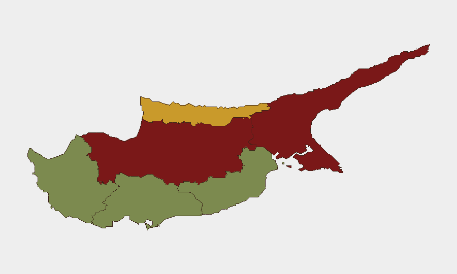
Nicosia (risk 92) and Famagusta (risk 88) dominate the threat profile, reflecting the capital's role in inter-communal tensions, divided governance, and historical flashpoints, combined with Famagusta's status as a contested, militarized zone. Kyrenia (risk 72) extends this pattern into the northern coast. By contrast, the southern and western resort zones—Limassol, Larnaca, Paphos—score substantially lower (18–28), though recent crime incidents in Limassol and Paphos suggest localized property and violent-crime upticks unrelated to political risk. The north-south disparity is driven by partition-legacy volatility, not current operational instability in the south.
How GeoBit Would Assist
Security teams with personnel or assets in Cyprus should employ AOI Monitoring & Early Warning on Nicosia and Famagusta to detect inter-communal escalation or protest activity before it affects business continuity, and Routing & Network Analysis to plan alternative movement during holiday periods and heat-stress events. Intel Sweep and multi-language OSINT (covering Greek, Turkish, and English sources) provide real-time corroboration of localized crime patterns, protest activity, and environmental hazards; sentiment and temporal analysis can flag emerging clusters. Satellite & Imagery analysis offers situational awareness of border-zone activity and protest staging.
7-Day Outlook
Heat and forest-fire risk will likely persist through mid-August, creating operational strain on emergency services and potential evacuation zones. August 15 holiday traffic, combined with police enforcement, will elevate road-safety risk. No political escalation is forecast, but the August 1964 memorial season (through mid-August) may sustain minor cross-line movement and localized activism in the north; these remain low-disorder events. Petty street crime in Limassol and rural burglary in Paphos warrant continued tactical awareness but pose no systemic threat.
Highest-Risk Areas — Ranked
| # | State / Region | Risk |
|---|---|---|
| 1 | Nicosia | 92 |
| 2 | Famagusta | 88 |
| 3 | Kyrenia | 72 |
| 4 | Larnaca | 28 |
| 5 | Limassol | 22 |
| 6 | Paphos | 18 |
Sources
Previous Daily Briefs
A new Cyprus brief is written every day — each with its own risk map and downloadable CSV. Here's the last week; use the calendar to go further back.
📅 Browse every day by calendar →
Highlighted days have a brief. Tap a day for that day's map & analysis, or “csv” for that day's dataset ($5).
Atlas — our AI intelligence desk — emails them this snapshot personally. Nothing else, no list.