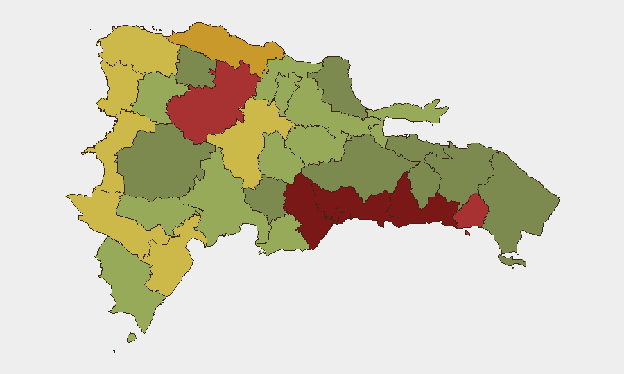
Situation Summary
Dominican Republic remains a moderate-risk destination (global rank #77, composite score 15) with persistent urban violent-crime threats concentrated in the capital and industrial zones. The country has experienced multiple unconventional-violence signals in the past 48 hours involving state and non-state actors, alongside routine enforcement actions and a minor seismic event (M 4.0, 15 July). The security environment is stable relative to regional peers but requires sector-specific vigilance in high-crime provinces.
Key Developments
- 2026-07-15, National – Ambassador-level public statement regarding worker incident; specific location and nature under clarification via live research.
- 2026-07-14, Multiple provinces – Three separate unconventional-violence events reported: Iran-attributed activity, Palestinian-attributed activity, and settler-linked activity, all targeting Dominican Republic interests. Specific locations and casualty/damage status require 24-hour corroboration.
- 2026-07-14, National – New Jersey law enforcement conducted arrest/detain action involving Dominican Republic; cross-border implications under assessment.
- 2026-07-14, Cross-border – Dominican Republic seized or damaged property linked to Belize; incident context and scale being monitored.
- 2026-07-15, 41 km NNE Las Terrenas (Samaná Province) – Magnitude 4.0 earthquake recorded; no casualty or infrastructure-damage reports received at time of writing.
- Standing context (not 24-48h development) – Haiti–Dominican Republic land border remains closed and commercial aviation suspended; affects logistics and personnel movement.
Highest-Risk Areas
Santo Domingo (risk 92) and the Nacional District (88) are the dominant risk drivers, reflecting concentrated violent crime, trafficking activity, and informal-settlement volatility in the capital metro. San Cristóbal (85), San Pedro de Macorís (83), and La Romana (78) extend risk into the southern industrial belt, where port and manufacturing assets face theft, extortion, and cartel-affiliated disruption. Santiago (76) in the north and Puerto Plata (72) represent secondary but sustained concern; the border provinces (Elías Piña 70, Dajabón 68) carry lower absolute risk but serve as trafficking and irregular-movement corridors. Operations or assets in the top four provinces require elevated duty-of-care protocols.
How GeoBit Would Assist
A corporate security team operating in Dominican Republic would deploy AOI Monitoring & Early Warning on Santo Domingo, San Cristóbal, and San Pedro de Macorís to detect emerging trafficking, protest, or gang activity in real time. Intel Sweep and multi-language OSINT fusion (including X/Twitter, Telegram, and local news monitoring) would clarify the nature and scope of the 14–15 July unconventional-violence signals and their connection to personnel or asset risk. GIS & Spatial Analysis would map high-threat corridors and support Routing & Network Analysis for personnel mobility and supply-chain continuity planning during periods of heightened activity.
7-Day Outlook
No imminent national-level crisis is indicated; however, the cluster of unconventional-violence signals on 13–14 July warrants 48–72 hour clarification. Urban crime and trafficking pressures are expected to remain steady in Metro Santo Domingo and the south-coast industrial zone. Personnel and asset managers should maintain heightened situational awareness and liaison with local authorities; border-adjacent operations should anticipate continued closure status.
Highest-Risk Areas — Ranked
| # | State / Region | Risk |
|---|---|---|
| 1 | Santo Domingo | 92 |
| 2 | Nacional District | 88 |
| 3 | San Cristóbal | 85 |
| 4 | San Pedro de Macorís | 83 |
| 5 | La Romana | 78 |
| 6 | Santiago | 76 |
| 7 | Puerto Plata | 72 |
| 8 | Elías Piña | 70 |
| 9 | Dajabón | 68 |
| 10 | Barahona | 65 |
| 11 | Independencia Province | 64 |
| 12 | La Vega | 62 |
Sources
Previous Daily Briefs
A new Dominican Republic brief is written every day — each with its own risk map and downloadable CSV. Here's the last week; use the calendar to go further back.
📅 Browse every day by calendar →
Highlighted days have a brief. Tap a day for that day's map & analysis, or “csv” for that day's dataset ($5).
Atlas — our AI intelligence desk — emails them this snapshot personally. Nothing else, no list.