Situation Summary
DR Congo remains at elevated civil-conflict risk (composite threat score 72, #17 globally), driven primarily by armed-group activity in the eastern provinces and ongoing political tension in the capital. The security environment is further complicated by a concurrent Ebola outbreak in Ituri Province, which has reached 837 confirmed cases and 196 deaths as of 18 June, with insecurity hampering containment efforts. While no major discrete armed clashes were independently verified in the last 48 hours, baseline conflict activity persists across the North Kivu and Tshopo regions, and political instability in Kinshasa poses secondary risk to operations in the capital.
Key Developments
- Ituri Province, 18 June — Ebola outbreak case count rose to 837 confirmed cases and 196 deaths, with 29 new cases reported in the preceding 24 hours; WHO flagged insecurity, displacement, and population movement as primary obstacles to outbreak containment.
- Ituri Province, 17–18 June — WHO expanded Ebola response capacity in-country; health-security operations remain vulnerable to disruption from armed activity and population displacement in the province.
- Kinshasa, 15 June — Security forces dispersed anti-constitutional-reform protesters outside parliament using tear gas and live ammunition after demonstrators threw rocks; the Coalition Article 64 had organized the sit-in, with police, army, and pro-government militants deployed to block access (Reuters-sourced reporting).
- Eastern DRC (North Kivu, Tshopo, Lower Uele), 15–18 June — Baseline armed-group activity remained elevated but no new time-stamped discrete clashes or displacement events were independently verified in open-source monitoring during the 48-hour window.
Highest-Risk Areas
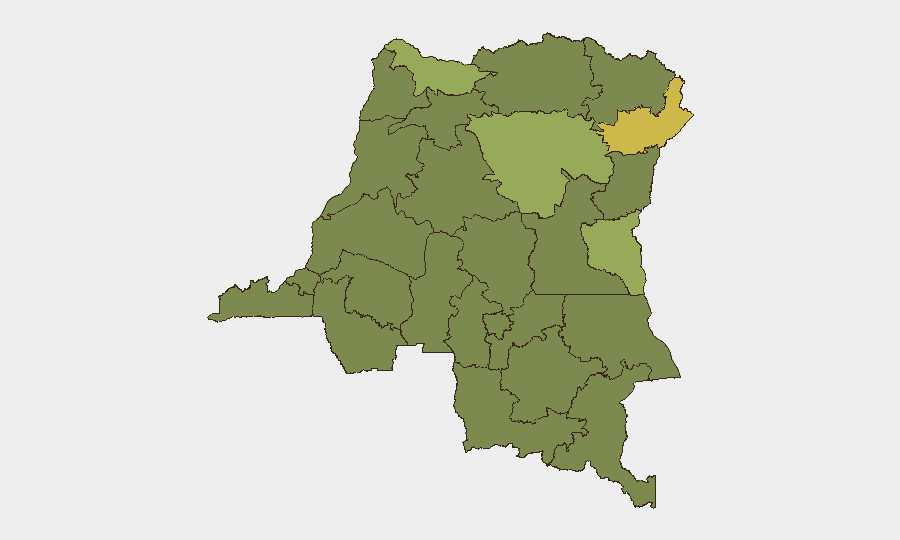
Ituri Province (risk 69.5) is the dominant driver of national threat; it combines active armed-group presence with an expanding Ebola outbreak that is degrading health infrastructure and population stability. Tshopo (55.7) presents secondary armed-conflict risk, while a cluster of provinces across the north and east (Nord-Ubangi, South Kivu, Maniema, Équateur, North Kivu) all score 39.5–40.7 and reflect sustained low-to-moderate armed activity and displacement pressures. Kinshasa, while not separately ranked, carries distinct political-instability risk tied to ongoing constitutional disputes and security-force deployments; operations in the capital should account for protest activity and capital-security responses.
How GeoBit Would Assist
Security teams operating in DR Congo would prioritize AOI Monitoring & Early Warning on Ituri and Tshopo provinces to detect armed clashes, displacement events, and health-emergency signals in near-real time. Conflict & Military capabilities—including battle mapping, force-structure tracking, and armed-group network analysis—enable situational awareness of M23, CODECO, and other key actors driving eastern volatility. Intel Sweep, OSINT fusion, and multi-language search allow continuous ingestion of Swahili, French, and local-language reporting to fill gaps in English-language open-source coverage and improve verification of incident claims before they become operational surprises.
7-Day Outlook
The Ebola outbreak in Ituri is likely to remain the dominant near-term driver of humanitarian and health-security disruption; armed-group activity could further restrict humanitarian access. Political tension in Kinshasa may produce additional protest activity and security-force deployments around parliament, but no major escalation is currently forecast. Baseline armed conflict in the eastern provinces is expected to persist at current levels absent a major political shift or external military intervention.
Highest-Risk Areas — Ranked
| # | State / Region | Risk |
|---|---|---|
| 1 | Ituri | 69.5 |
| 2 | Tshopo | 55.7 |
| 3 | Nord-Ubangi | 40.7 |
| 4 | South Kivu | 40.7 |
| 5 | Maniema | 39.5 |
| 6 | Sud-Ubangi | 39.5 |
| 7 | Équateur | 39.5 |
| 8 | Mongala | 39.5 |
| 9 | Lower Uele | 39.5 |
| 10 | Tshuapa | 39.5 |
| 11 | Upper Uele | 39.5 |
| 12 | North Kivu | 39.5 |
Sources
Previous Daily Briefs
A new DR Congo brief is written every day — each with its own risk map and downloadable CSV. Here's the last week; use the calendar to go further back.
📅 Browse every day by calendar →
Highlighted days have a brief. Tap a day for that day's map & analysis, or “csv” for that day's dataset ($5).