Situation Summary
Ecuador faces sustained organized criminal violence centered on narcotics trafficking, prison control, and territorial disputes among rival criminal organizations. The country's composite threat score of 56 reflects 55 tracked violent events, with primary drivers rooted in competition for drug-trafficking routes and incarceration facility control. Recent signal activity (22–23 June) indicates heightened state response measures, inter-agency friction, and possible border-adjacent military activity. The security environment remains volatile with limited signs of de-escalation.
Key Developments
- National Level (23 June): Presidential demand issued; separate rejection of presidential authority reported. Cabinet-level demand directed at criminal actors; indicates policy response escalation and possible institutional strain.
- Guayaquil (23 June): Public statement issued from the city; Guayaquil remains the second-highest-risk province (56.7) and the locus of most reported gang and police activity. Specific incident details unconfirmed in available 24-h sources.
- Border/Military (23 June): Conventional military force deployment reported involving Peru and Ecuador; separate military-vs.-intellectual/presidential-candidate signal noted. Indicates either cross-border tension or internal military-political friction; requires urgent verification.
- Criminal Operations (22 June): Conventional military force deployed against criminal actors; small-arms combat reported (21 June). Suggests active state security operations, likely anti-gang raids or prison-control enforcement.
- Institutional (21–22 June): Arrest/detention activity by authorities; school-vs.-ministry conventional military force signal. Suggests possible institutional conflict or security operation within state infrastructure.
Note: Web-sourced corroboration for specific incident timings and locations remains incomplete. Recent unconfirmed social media references include gang activity near Guayaquil airport and a state-of-exception declaration in multiple provinces; independent news verification needed.
Highest-Risk Areas
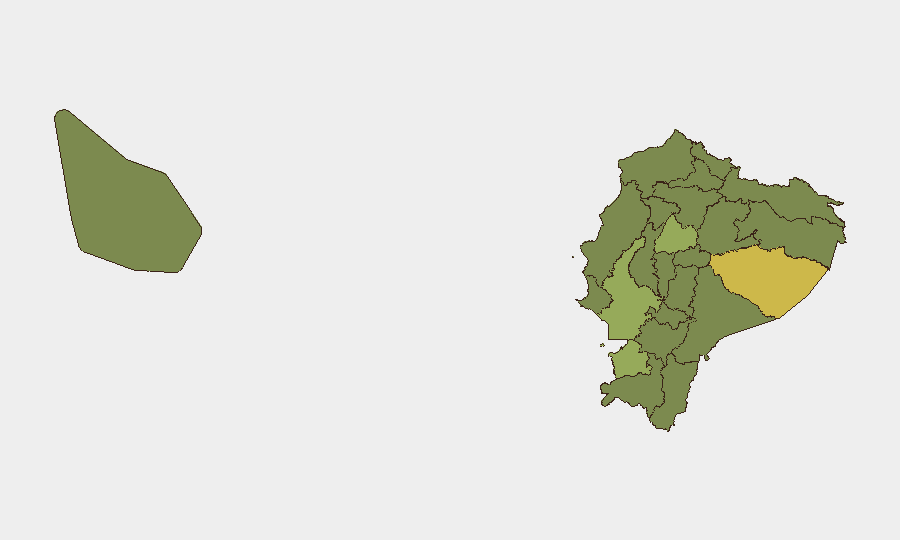
Pastaza Province (69.4) represents the single highest composite risk, driven by remoteness, weak state presence, and use as a drug-trafficking transshipment zone. Guayas Province (56.7)—encompassing Guayaquil and the Pacific coast—ranks second; it is Ecuador's economic hub and primary locus of inter-cartel violence, prison riots, and police–criminal engagement. El Oro (42.5), Cotopaxi (41.4), and Carchi (39.7) follow, representing southern, central-highland, and northern border vulnerabilities respectively. The northern provinces (Carchi, Sucumbíos, Orellana, Esmeraldas) and Manabí reflect trafficking-route concentration and limited state capacity; Galápagos (39.4) signals emerging criminal interest in the archipelago, likely money-laundering or narcotics staging.
How GeoBit Would Assist
Security teams with personnel or assets in Ecuador should employ Intel Sweep and global event feeds for real-time incident corroboration and timeline validation; X/Twitter & Telegram OSINT to detect criminal organization announcements, gang threats, or police operations; and AOI Monitoring & Early Warning on Guayaquil, Pastaza, and border crossings to flag emerging threats. Conflict & Military mapping and Network & Actor Analysis enable tracking of cartel structure changes and state security posture. Risk & Threat Assessment and Sentiment & Temporal Analysis support duty-of-care decision-making on staff movement and facility hardening.
7-Day Outlook
State security operations are likely to continue with elevated tempo through late June, particularly in Guayaquil and high-trafficking provinces. Border activity and inter-institutional signals suggest possible policy turbulence; criminal organizations may respond with retaliatory violence or operational acceleration. Threat posture is expected to remain elevated; any de-escalation would require multiagency coordination and cartel negotiation, neither of which is currently evident.
Highest-Risk Areas — Ranked
| # | State / Region | Risk |
|---|---|---|
| 1 | Pastaza Province | 69.4 |
| 2 | Guayas Province | 56.7 |
| 3 | El Oro Province | 42.5 |
| 4 | Cotopaxi Province | 41.4 |
| 5 | Carchi Province | 39.7 |
| 6 | Sucumbíos Province | 39.4 |
| 7 | Orellana Province | 39.4 |
| 8 | Manabí Province | 39.4 |
| 9 | Galápagos | 39.4 |
| 10 | Esmeraldas Province | 39.4 |
| 11 | Imbabura Province | 39.4 |
| 12 | Santo Domingo de los Tsáchilas Province | 39.4 |
Sources
Previous Daily Briefs
A new Ecuador brief is written every day — each with its own risk map and downloadable CSV. Here's the last week; use the calendar to go further back.
📅 Browse every day by calendar →
Highlighted days have a brief. Tap a day for that day's map & analysis, or “csv” for that day's dataset ($5).