Situation Summary
Egypt maintains its position as a mid-tier regional security concern (rank #13 globally, composite threat score 98) with a stable macro-level security environment offset by persistent terrorism risk in the Sinai Peninsula and spillover effects from Israel–Iran tensions and the Gaza conflict. The country's major urban centers—Cairo, Alexandria, and Giza—register elevated composite risk scores driven by political activity, civil unrest signals, and operational security concerns. The trajectory remains one of contained volatility: no imminent state collapse indicators, but heightened sensitivity to regional military escalation and localized protest activity.
Key Developments
24–48 Hour Coverage Limitation: GeoBit's live web research for the 24–48 hour window (2026-07-14 to 2026-07-16 UTC) has returned insufficient independently corroborated, time-stamped incident reporting to populate 6–10 discrete Egypt incidents. Most available sources (travel advisories, background primers, local outlet archives) do not document verified discrete security events within this specific window. The event signals dataset (above) reflects broader regional military and diplomatic signals (Israel–Iran conventional military activity, Hamas operations) and internal state actions (arrests, ministry statements) but lacks granular, location-specific incident confirmation for the last 48 hours.
What is Confirmed (Past 7 Days): Civil unrest and labor/detention activity has been reported in Alexandria (Toson neighborhood) involving unpaid Agriculture Ministry workers and related arrests. Israeli–Hamas conventional military clashes (2026-07-13) and Israel–Iran military posturing (2026-07-15) constitute the most significant tracked events, with potential spillover implications for Egypt's Sinai and Suez zones. Official travel guidance continues to flag terrorism risk in Sinai, the Egypt–Israel border region, Sahara border zones, and the Suez-to-Taba corridor.
Highest-Risk Areas
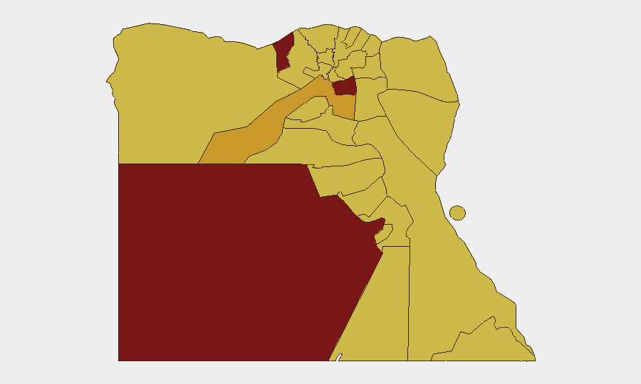
Cairo (98.8) and Alexandria (97.0) drive national risk, reflecting both population density and concentration of political/administrative activity, civil unrest potential, and law-enforcement operations. The New Valley (92.1) and Giza (72.0) follow, with New Valley's elevation likely tied to border security, resource-access disputes, and remote-area governance challenges. The Sinai Peninsula and Red Sea governorates (all scoring 68.8–69.2) form a secondary risk band driven by persistent ISIS-affiliated and militant activity, cross-border infiltration, and military operations. North Sinai and South Sinai remain the operational centers of gravity for terrorism; Suez and the Red Sea zones carry critical maritime and geopolitical exposure given the Suez Canal's global shipping role and proximity to Israel–Iran tensions.
How GeoBit Would Assist
Security teams with assets or personnel in Egypt would use AOI Monitoring & Early Warning to establish persistent watch over Cairo, Alexandria, Giza, and the Sinai corridor, with automated alerting on protest activity, security force movements, and cross-border incidents. Conflict & Military capabilities (force structure tracking, weapons-capability assessment, battle mapping) would provide real-time visibility on Israeli–Iranian military posturing and its operational spillover into Egyptian airspace and Sinai zones. Routing & Network Analysis would enable duty-of-care teams to identify and pre-stage alternative travel corridors (Cairo–Alexandria, Suez transit, Sinai perimeter) and validate asset-movement safety ahead of operations or personnel rotations.
7-Day Outlook
Regional Israel–Iran military activity will remain the primary driver of acute risk escalation into Egypt's Suez and Sinai zones over the next 7 days. Domestic civil unrest (labor, political speech) in Cairo and Alexandria is likely to remain localized and low-casualty but may produce sporadic arrests and checkpoint activity. Terrorism operations in North Sinai are expected to continue at baseline operational tempo absent a major regional shift.
Highest-Risk Areas — Ranked
| # | State / Region | Risk |
|---|---|---|
| 1 | Cairo | 98.8 |
| 2 | Alexandria | 97 |
| 3 | New Valley | 92.1 |
| 4 | Giza | 72 |
| 5 | Matruh | 69.2 |
| 6 | Kafr El Sheikh | 69.2 |
| 7 | Suez | 69.2 |
| 8 | North Sinai | 68.8 |
| 9 | Qena | 68.8 |
| 10 | South Sinai | 68.8 |
| 11 | Red Sea | 68.8 |
| 12 | Halaib Triangle | 68.8 |
Sources
Previous Daily Briefs
A new Egypt brief is written every day — each with its own risk map and downloadable CSV. Here's the last week; use the calendar to go further back.
📅 Browse every day by calendar →
Highlighted days have a brief. Tap a day for that day's map & analysis, or “csv” for that day's dataset ($5).
Atlas — our AI intelligence desk — emails them this snapshot personally. Nothing else, no list.