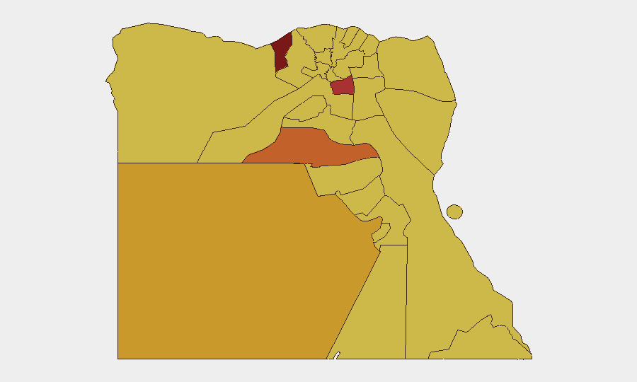
Situation Summary
Egypt remains at composite threat rank #17 globally with a score of 96, reflecting a generally stable domestic security environment but elevated regional conflict risk. The past 48 hours have been marked by a significant transport-safety incident rather than terrorism or civil unrest, though underlying terrorism risk and regional volatility persist. Political tensions are noted as elevated but contained, while Middle East regional escalation is creating secondary risks to aviation and travel corridors affecting Egypt.
Key Developments
- Matrouh Governorate train derailment – 18 July 2026
A passenger train derailed on a railway line in north-west Egypt's Matrouh governorate, killing 3 people and injuring 94. This represents a significant infrastructure and transport-safety risk indicator for the region and reinforces ongoing concern over rail safety in Egypt.
- Regional conflict spill-over risk – escalating Middle East tensions (current advisory status)
Australian Smartraveller and German Foreign Office advisories (updated within the past 48 hours) note that recent military strikes and reprisal attacks across the Middle East have already begun triggering flight disruptions and airspace closures. EASA has advised operators to avoid Gulf airspace until at least 29 July 2026, affecting Egypt-bound and Egypt-transit air traffic.
- Terrorism threat remains unchanged but elevated nationwide
German Foreign Office advisory (current as of mid-July) confirms the security situation in Egypt is "overall stable and calm" but reinforces that new terrorist attacks cannot be ruled out, particularly given regional military tensions. This reflects persistent, low-frequency but credible terrorism risk across the country.
- North Sinai and border zones remain under no-travel restrictions
Ongoing formal travel warnings remain in effect for North Sinai governorate, Gaza border areas, and most of the Egypt–Israel border zone, citing persistent risk of terrorist attacks, armed clashes, and kidnapping. Remote Sahara border areas with Libya and Sudan likewise remain Egyptian-government-declared restricted zones.
- Labor unrest and administrative pressure noted in past week
Unconfirmed open-source reporting indicates labor protests and arrests at the Agriculture Ministry and coercive eviction-related intimidation in Alexandria's Toson neighborhood over the past week, though precise timing falls outside the 24–48-hour window and requires monitoring for escalation.
Highest-Risk Areas
Alexandria (97.5) and Cairo (77.2) dominate the sub-national risk ranking and drive Egypt's overall threat score, reflecting both urban density and historical concentration of protest, terrorism, and organized activity. Al Minya, New Valley, and North Sinai (68.6) follow, with North Sinai's elevation reflecting persistent Sinai insurgency risk and cross-border instability. Border and remote governorates (Matruh, Red Sea, Halaib Triangle) show elevated and uniform risk scores, consistent with transport-safety incidents, smuggling networks, and regional conflict spillover. Alexandria's exceptionally high score warrants focused monitoring given its port infrastructure, political sensitivity, and recent labor unrest reports.
How GeoBit Would Assist
Security teams should deploy AOI Monitoring & Early Warning on Alexandria, Cairo, and North Sinai to catch emerging protests, security incidents, or terrorist activity before operational impact. Conflict & Military and Network & Actor Analysis capabilities enable tracking of Sinai insurgent activity and regional militia movements affecting Egypt's borders. Aviation & Maritime tracking combined with Routing & Network Analysis allow real-time alternative journey and supply-chain planning around airspace closures and transport-safety risks, with Intel Sweep and X/Twitter OSINT providing 24–48-hour early warning of security escalation.
7-Day Outlook
Near-term trajectory remains stable domestically but increasingly vulnerable to regional escalation. If Middle East tensions do not de-escalate by 29 July, airspace restrictions will likely extend and secondary economic/logistical disruption will increase. Terrorism risk remains constant; any incident in Cairo, Alexandria, or tourist zones would trigger immediate travel-advisory upgrades and operational disruption.
Highest-Risk Areas — Ranked
| # | State / Region | Risk |
|---|---|---|
| 1 | Alexandria | 97.5 |
| 2 | Cairo | 77.2 |
| 3 | Al Minya | 74.1 |
| 4 | New Valley | 72.5 |
| 5 | North Sinai | 68.6 |
| 6 | Giza | 67.9 |
| 7 | Qena | 67.5 |
| 8 | South Sinai | 67.5 |
| 9 | Red Sea | 67.5 |
| 10 | Halaib Triangle | 67.5 |
| 11 | Matruh | 67.5 |
| 12 | Kafr El Sheikh | 67.5 |
Sources
Previous Daily Briefs
A new Egypt brief is written every day — each with its own risk map and downloadable CSV. Here's the last week; use the calendar to go further back.
📅 Browse every day by calendar →
Highlighted days have a brief. Tap a day for that day's map & analysis, or “csv” for that day's dataset ($5).
Atlas — our AI intelligence desk — emails them this snapshot personally. Nothing else, no list.