Situation Summary
Fiji remains a low-threat environment (global rank #64; composite score 28), with no active tracked conflict, terrorism, or organized crime networks. The current threat picture is dominated by isolated incidents—a maritime disaster involving healthcare workers, fatal traffic collision, and one homicide—distributed across multiple incident categories rather than concentrated in a single systemic risk. No escalation trajectory is evident; incidents appear sporadic and unrelated.
Key Developments
- 2026-08-07 · Road Traffic Fatality (Central Region): Four-vehicle collision at Vakabalea claimed the lives of Kaminieli Matadradra (70) and Setaita (67) while en route to Australia. Indicates ongoing road-safety hazard in Central region.
- 2026-08-06 · Maritime Distress (Eastern Region – Lau Group): Fiberglass medical outreach vessel MD Ono-i-Lau suffered engine failure with six healthcare workers aboard; vessel failed to reach destination under strong wind conditions. Status of crew unconfirmed as of reporting.
- 2026-08-05 · Homicide Investigation (Central Region – Tama): Police arrested a 29-year-old male in connection with the death of a 12-year-old boy discovered near his home. Classified as violence against civilians; investigation ongoing.
- 2026-08-05 · Maritime Missing Persons (Eastern Region – Lau Group): Six healthcare workers remain unaccounted for following engine failure of MD Ono-i-Lau during medical outreach. Search status not confirmed in available reporting.
Highest-Risk Areas
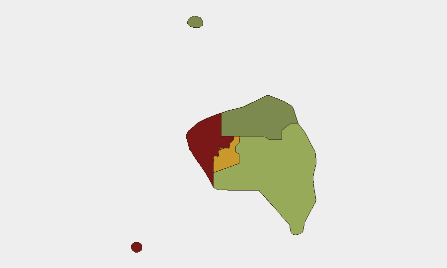
Western region (risk score 85) presents the highest sub-national threat, driven by concentrated incidents and underlying security fragmentation. Central region (score 72) ranks second and accounts for two of the four major incidents this week—the fatal road collision and homicide investigation—indicating elevated risk to ground transportation and personal security in that division. Eastern region (score 45) faces acute maritime hazard exposure, compounded by geographical isolation of the Lau Group and limited emergency response capacity. Northern (38) and Rotuma (12) remain substantially lower-risk. Corporate teams with assets or personnel in Western and Central regions should prioritize incident monitoring and duty-of-care protocols.
How GeoBit Would Assist
Teams managing Fiji operations can leverage Intel Sweep and multi-language event feeds to maintain real-time situational awareness of police investigations, maritime incidents, and road-safety alerts across all divisions. AOI Monitoring & Early Warning on Western and Central regions would enable persistent watch for emerging violence, trafficking, or organized-crime indicators before they escalate. Maritime & Aviation tracking combined with routing & network analysis would support contingency planning for medical outreach, supply, and personnel transport—reducing exposure to vessel engine failure and maritime distress by identifying alternative vessels, departure windows, and coastal staging points.
7-Day Outlook
No indicators suggest imminent systemic escalation. Isolated incidents—homicide, maritime casualty, road fatality—remain dispersed across geography and event type, with no apparent contagion effect or organized coordination. Monitoring should remain focused on resolution of the maritime search operation and outcomes of the Central-region homicide investigation; road-safety conditions in Central and Western regions warrant sustained attention given persistent collision patterns. Risk trajectory is stable.
Highest-Risk Areas — Ranked
| # | State / Region | Risk |
|---|---|---|
| 1 | Western | 85 |
| 2 | Central | 72 |
| 3 | Eastern | 45 |
| 4 | Northern | 38 |
| 5 | Rotuma | 12 |
Sources
Previous Daily Briefs
A new Fiji brief is written every day — each with its own risk map and downloadable CSV. Here's the last week; use the calendar to go further back.
📅 Browse every day by calendar →
Highlighted days have a brief. Tap a day for that day's map & analysis, or “csv” for that day's dataset ($5).
Atlas — our AI intelligence desk — emails them this snapshot personally. Nothing else, no list.