Situation Summary
Guinea-Bissau remains operationally stable with no verified security incidents, armed conflict, civil unrest, or travel disruptions reported in the last 24–48 hours. The country's composite threat ranking of #128 globally (score 8) reflects baseline West African regional risks rather than active acute threats. The ECOWAS Stabilization Support Mission continues routine operations; no new destabilizing events have been detected.
Key Developments
- No verified incidents in the last 24–48 hours across Guinea-Bissau's national territory, capital, or major urban centers (Bissau, Gabu, Bafatá).
- ECOWAS mission rotation concluded 2026-08-05 in Bissau sector (Nigerian troop hand-over); routine logistics activity, not a security event.
- Travel advisory status unchanged as of latest check; no new risk escalation signaled by diplomatic sources.
- Countrywide stability maintained; no reports of armed confrontation, organized crime activity, or political instability in current monitoring window.
Highest-Risk Areas
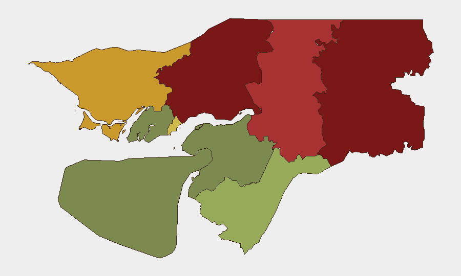
Gabu Region (risk 92) and Oio Region (risk 85) drive the country's composite threat profile, likely reflecting cross-border trafficking, arms movement, and historical instability along the Senegal frontier. Bafatá Region (78) and Cacheu Region (72) present secondary risk corridors; these northeastern and northwestern areas remain vulnerable to spillover from regional West African organized crime and smuggling networks. Bissau Autonomous Sector (68), despite being the capital, ranks fifth, suggesting risk concentration in remote border regions rather than the administrative center. Southern regions (Tombali, Quinara, Bolama) show substantially lower threat scores, indicating a geographic north-south risk gradient.
How GeoBit Would Assist
AOI Monitoring & Early Warning with persistent watch on Gabu, Oio, and Bafatá regions would provide 24-hour alert capability for cross-border movement, armed group activity, or trafficking indicators before they affect corporate operations or personnel. OSINT Fusion & Corroboration (multi-language search, social-media monitoring, and radio SIGINT in border zones) would detect emerging civil unrest, political tension, or security force activity ahead of mainstream reporting. Routing & Network Analysis would allow duty-of-care teams to model alternative supply-chain and personnel-movement paths away from highest-risk corridors (especially Gabu–Senegal border) in the event of rapid deterioration.
7-Day Outlook
No acute escalation is anticipated in the near term; the country's stability baseline is expected to hold barring significant external regional shock (e.g., major Senegal-Mali border crisis). Continued monitoring of Gabu and Oio regions for cross-border trafficking and informal armed movement remains prudent given historical volatility. Standard duty-of-care protocols for northern-region operations should remain in effect.
Highest-Risk Areas — Ranked
| # | State / Region | Risk |
|---|---|---|
| 1 | Gabu Region | 92 |
| 2 | Oio Region | 85 |
| 3 | Bafatá Region | 78 |
| 4 | Cacheu Region | 72 |
| 5 | Bissau Autonomous Sector | 68 |
| 6 | Tombali Region | 45 |
| 7 | Quinara Region | 38 |
| 8 | Biombo Region | 32 |
| 9 | Bolama Region | 15 |
Sources
Previous Daily Briefs
A new Guinea-Bissau brief is written every day — each with its own risk map and downloadable CSV. Here's the last week; use the calendar to go further back.
📅 Browse every day by calendar →
Highlighted days have a brief. Tap a day for that day's map & analysis, or “csv” for that day's dataset ($5).
Atlas — our AI intelligence desk — emails them this snapshot personally. Nothing else, no list.