Situation Summary
Guyana remains a low-threat environment globally (rank #92, composite score 14) with no tracked discrete security events in the current window. However, sub-national risk concentration in coastal urban and interior mining regions—particularly Demerara-Mahaica and Cuyuni-Mazaruni—reflects ongoing challenges in violent crime, trafficking, and resource-driven instability. Recent incident activity suggests persistent but localized crime and civil tension rather than systemic deterioration.
Key Developments
- Sophia, Greater Georgetown (2026-08-05): Guyana Police Service recovered an AK-pattern assault rifle and two magazines from a dry drain during a search operation; no arrests reported. Recovery indicates ongoing illicit firearms circulation in the capital region.
- Linden / Watuka House, Region 10 (2026-08-04): A protest and standoff occurred as Vice President Barrett Jagdeo arrived for public outreach; demonstrators confronted the government delegation. Reflects underlying civil grievances in the interior, though event remained non-violent.
- Coverden Public Road (2026-08-06): A fatal motor-vehicle collision involving a van and motorcycle resulted in one death (21-year-old rider) and one hospitalization. Road safety remains a significant incident driver but is non-security related.
- General: No terrorist attacks, kidnappings, mass-casualty incidents, or security force engagements reported in the last 48 hours.
Highest-Risk Areas
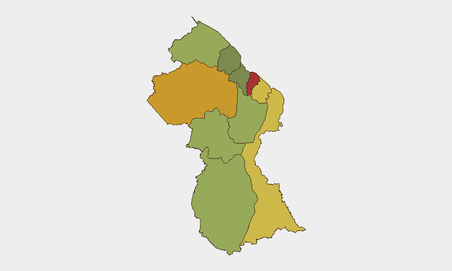
Demerara-Mahaica (risk 78) and Cuyuni-Mazaruni (risk 72) dominate the sub-national risk profile. The former encompasses Georgetown and the immediate coastal zone, where firearms availability, gang activity, and street crime create persistent operational hazard. Cuyuni-Mazaruni's interior mining and frontier character—combined with cross-border permeability and trafficking routes—elevates exposure to organized criminal and transnational threats. Mahaica-Berbice (65) and East Berbice-Corentyne (62) extend this corridor of concern eastward. Together, these four regions account for the majority of national risk concentration and should remain priority focus areas for personnel safety and asset protection protocols.
How GeoBit Would Assist
Security teams should deploy AOI Monitoring & Early Warning on high-risk regions (particularly Georgetown commercial/diplomatic zones and mining-region transport routes) to receive alerting on trafficking, trafficking incidents, and civil unrest. Network & Actor Analysis and multi-language OSINT (X/Telegram/local news feeds) would enable real-time detection of criminal or trafficking actor movement and operational intent. Routing & Network Analysis would support alternative-route planning for personnel and supply movements, avoiding documented crime hotspots and protest sites in real time.
7-Day Outlook
No imminent major security escalation is forecast. Violent crime, firearms trafficking, and localized civil tension will likely persist at current baseline levels in coastal and interior zones. Monitoring should focus on mining-region stability and cross-border criminal activity, particularly given Cuyuni-Mazaruni's exposure to organized networks and transnational routes.
Highest-Risk Areas — Ranked
| # | State / Region | Risk |
|---|---|---|
| 1 | Demerara-Mahaica | 78 |
| 2 | Cuyuni-Mazaruni | 72 |
| 3 | Mahaica-Berbice | 65 |
| 4 | East Berbice-Corentyne | 62 |
| 5 | Upper Demerara-Berbice | 58 |
| 6 | Potaro-Siparuni | 48 |
| 7 | Barima-Waini | 45 |
| 8 | Upper Takutu-Upper Essequibo | 42 |
| 9 | Pomeroon-Supenaam | 38 |
| 10 | Essequibo Islands | 35 |
Sources
Previous Daily Briefs
A new Guyana brief is written every day — each with its own risk map and downloadable CSV. Here's the last week; use the calendar to go further back.
📅 Browse every day by calendar →
Highlighted days have a brief. Tap a day for that day's map & analysis, or “csv” for that day's dataset ($5).
Atlas — our AI intelligence desk — emails them this snapshot personally. Nothing else, no list.