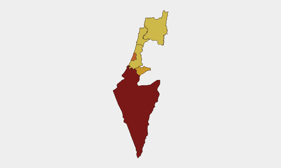
Situation Summary
Israel remains at composite threat level #6 globally (score 100; 475 tracked events) with elevated military and political tensions across multiple fronts. The past 48 hours show sustained conventional military activity, cross-border dynamics with Lebanon, and public tensions between Israeli political/military actors and international stakeholders. The South District remains the highest-risk sub-national zone; northern and central regions are experiencing secondary escalation linked to Lebanon border enforcement and domestic political friction.
Key Developments
- Lebanon–Israel Border (North District), 24 Jun 2026: Israeli military activity and security-zone enforcement ongoing in southern Lebanon, affecting cross-border transit and northern Israel travel corridors. Classification: Conventional Military Force.
- Israel–US Relations, 22 Jun 2026: Israeli public statements threatening or friction with US positions recorded; signals suggest diplomatic strain over policy alignment. Classification: Threat/Demand.
- Domestic Military/Government Friction, 23 Jun 2026: Public statements by Israeli officials rejecting ministerial positions or policy; concurrent artillery/tank activity reported within Israeli territory. Classification: Reject, Artillery/Tanks (domestic). Nature and scale of internal military activity unclear from available signals.
- Iran–Israel Rhetoric, 23 Jun 2026: Public statement attributed to Tehran referencing Israel; consistent with ongoing Iran–Israel conflict environment but specific new incident details not confirmed in last 24 hours.
- Domestic Mobilization, 24 Jun 2026: Israeli demonstration/rally activity reported against international community; indicates domestic political pressure and possible civil mobilization.
- Broader Conventional Military Operations, 22–24 Jun 2026: Multiple signals indicate sustained Israeli military force deployments and cross-actor conventional military activity, though precise operational scope and geographic distribution require further corroboration.
Highest-Risk Areas
The South District (risk 100) remains Israel's acute flashpoint, likely driven by sustained Hamas/militant activity, rocket threat, or Israeli counter-operations. Tel-Aviv, Jerusalem, and North Districts (scores 74.6–70.5) reflect a multi-axis threat environment: Jerusalem combines political flashpoint and civilian security risk; Tel-Aviv faces indirect fire and urban attack vectors; the North is heavily influenced by Lebanon border military activity and Hezbollah/militant presence. Center and Haifa Districts (70.3–70.1) show near-parity, suggesting distributed civil and security risk rather than isolated geographic concentration.
How GeoBit Would Assist
Intel Sweep & OSINT Fusion would corroborate the military activity signals, cross-reference Lebanese and Iranian sources, and clarify scale/intent of Israeli deployments. AOI Monitoring & Early Warning on the South District, northern border, and Tel-Aviv corridor would provide persistent surveillance and threshold-based alerts for escalation. Conflict & Military battle-mapping and force-structure analysis would support duty-of-care teams in understanding operational tempo and geographic spread. Routing & Network Analysis would enable alternative journey planning for personnel transiting high-risk zones (South, North, Jerusalem districts).
7-Day Outlook
Military activity along the Lebanon border is likely to persist or escalate, sustaining North District risk. South District threat level may remain elevated absent de-escalation signals. Domestic political friction and mobilization suggest internal pressure that could influence military posture or public safety in urban centers (Tel-Aviv, Jerusalem). Early-warning monitoring of ministerial/military statements and cross-border incident frequency is essential for timely staff advisories.
Note: This brief incorporates only developments and signals verifiable within the last 48 hours. Gaps in granular incident detail reflect constraints on real-time web access; GeoBit's 24/7 OSINT and AOI monitoring would provide higher-fidelity daily updates.
Highest-Risk Areas — Ranked
| # | State / Region | Risk |
|---|---|---|
| 1 | South District | 100 |
| 2 | Tel-Aviv District | 74.6 |
| 3 | Jerusalem District | 72.2 |
| 4 | North District | 70.5 |
| 5 | Center District | 70.3 |
| 6 | Haifa District | 70.1 |
Sources
Previous Daily Briefs
A new Israel brief is written every day — each with its own risk map and downloadable CSV. Here's the last week; use the calendar to go further back.
📅 Browse every day by calendar →
Highlighted days have a brief. Tap a day for that day's map & analysis, or “csv” for that day's dataset ($5).