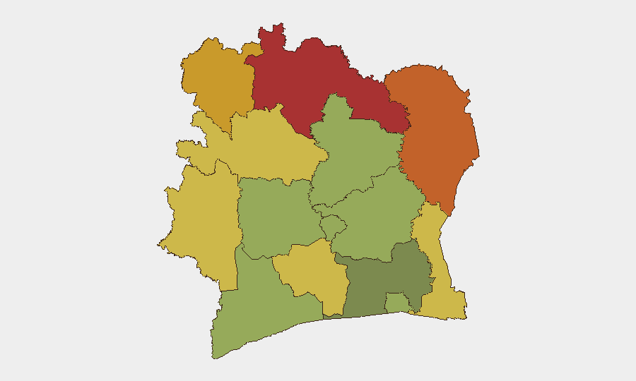
Situation Summary
Ivory Coast remains a stable lower-tier risk environment globally (#60 composite), but with pronounced geographic volatility: the northern and northeastern border districts face significantly elevated threat levels driven by transnational armed group activity, smuggling networks, and porous frontier controls. Central Abidjan and southern districts maintain manageable baseline risk. Recent signal activity (7 tracked events in 24–48 hours, including governmental and corporate statements) suggests active policy or contractual tension, though specific incident details remain limited in open reporting.
Key Developments
Open-source reporting has not yielded specific, independently corroborated security incidents in Ivory Coast clearly dated to 2026-07-16 or 2026-07-17. GeoBit's event signals show activity flagged as "Public Statement" (Consul General, government vs. company, company, and executive statements) and administrative actions ("Disapprove" by Abidjan authorities; "Occupy Territory" by Côte d'Ivoire state), but underlying event details—location, nature, and immediate security consequence—are not yet granular in available web intelligence.
A demolition operation targeting informal settlements in Attécoubé, Abidjan, was reported as occurring "this week" but lacks precise dating and cannot be confidently placed within the last 48 hours; it carries localized tension and displacement risk if ongoing.
Recommended action: monitoring stations and field contacts should clarify the substance and timeline of the flagged governmental and corporate statements to assess whether they signal policy shift, labor dispute, environmental or contractual action, or other duty-of-care drivers.
Highest-Risk Areas
The northern tier—Savanes (78), Zanzan (75), Denguélé (72), and Comoé (70)—accounts for nearly half the country's composite risk. These districts border Mali, Burkina Faso, and Guinea, regions where jihadist franchises (JNIM, ISIS-Sahel) and criminal networks operate. Porous borders, minimal state presence, artisanal mining zones, and trafficking corridors create persistent ungoverned space. Montagnes and Woroba districts (68, 65) extend risk southwestward along Guinean and Liberian borders, where cross-border militia activity and smuggling remain endemic.
By contrast, Abidjan (45) and southern coastal districts maintain significantly lower risk profiles, reflecting state capacity concentration and economic activity. Northern and northeastern deployment of personnel or supply chains should assume elevated threat to movement, contractual performance, and physical security.
How GeoBit Would Assist
Corporate security and risk teams operating in Ivory Coast should employ AOI Monitoring & Early Warning on high-risk districts (particularly Savanes, Zanzan, Denguélé) to track cross-border incursions, armed group movement, and infrastructure threats in near-real time. Routing & Network Analysis supports alternative journey planning for personnel and logistics, avoiding known transit choke points in the north. Intel Sweep (multi-language OSINT, X/Twitter & Telegram feeds, entity extraction) provides rapid clarification of the flagged governmental and corporate statement signals, enabling faster duty-of-care response to policy or security developments.
7-Day Outlook
No imminent escalation is signaled, but the northern districts will remain persistently volatile through seasonal patterns and transnational pressure. Watch for clarification of the governmental-corporate tension flags; if policy-driven, implementation may create localized operational friction. Southern and coastal zones remain suitable for routine operations under standard due diligence.
Highest-Risk Areas — Ranked
| # | State / Region | Risk |
|---|---|---|
| 1 | Savanes District | 78 |
| 2 | Zanzan District | 75 |
| 3 | Denguélé District | 72 |
| 4 | Comoé District | 70 |
| 5 | Montagnes District | 68 |
| 6 | Woroba District | 65 |
| 7 | Gôh-Djiboua District | 60 |
| 8 | Sassandra-Marahoué District | 58 |
| 9 | Vallée du Bandama District | 55 |
| 10 | Bas-Sassandra District | 52 |
| 11 | Lacs District | 48 |
| 12 | Abidjan | 45 |
Previous Daily Briefs
A new Ivory Coast brief is written every day — each with its own risk map and downloadable CSV. Here's the last week; use the calendar to go further back.
📅 Browse every day by calendar →
Highlighted days have a brief. Tap a day for that day's map & analysis, or “csv” for that day's dataset ($5).
Atlas — our AI intelligence desk — emails them this snapshot personally. Nothing else, no list.