Situation Summary
Lebanon remains the world's third-highest composite threat environment, driven by active Israeli military operations targeting Hezbollah positions across southern and eastern regions. Over the past 24–48 hours, Israeli airstrikes and ground operations have caused at least 21 confirmed deaths and expanded evacuation orders northward across the Litani River, signaling potential geographic escalation. Concurrent Hezbollah rocket and guided-missile attacks on Israeli forces indicate sustained two-way military engagement with no indication of de-escalation momentum.
Key Developments
- Tyre and Ras al-Ain, South Governorate (20 June): Israeli airstrikes west and south of Tyre killed nine people in the coastal Ras al-Ain area; Health Ministry confirmed additional wounded. Strikes followed prior evacuation orders in the district.
- Nabatieh city and district, South Governorate (20–21 June): Sustained Israeli bombardment described by Médecins Sans Frontières as creating a "death trap," with emergency access severely constrained and multiple civilian casualties reported over the past day.
- Southern and eastern Lebanon, multiple locations including Litani River area (20–21 June): Israeli military reported striking over 150 alleged Hezbollah infrastructure sites, command locations, and rocket-launching positions overnight; Lebanese Health Ministry attributed at least 21 deaths to these operations across southern localities.
- Villages north of Litani River, South Governorate (20–21 June): Israeli military expanded evacuation orders for the first time to towns north of the Litani River, previously described as Hezbollah strongholds, increasing civilian displacement and movement restrictions.
- Southern Lebanon border sector (20 June): Hezbollah claimed ambush of an Israeli unit, reporting destruction of three vehicles and engagement with guided munitions, rockets, and artillery; Israeli military acknowledged four soldiers killed in recent southern Lebanon operations overlapping this timeframe.
- Lebanon-wide travel advisory (20–21 June): Foreign governments updated "Do not travel" ratings citing armed conflict, civil unrest, terrorism, and volatile military operations in southern governorates with risk of sudden disruption.
Highest-Risk Areas
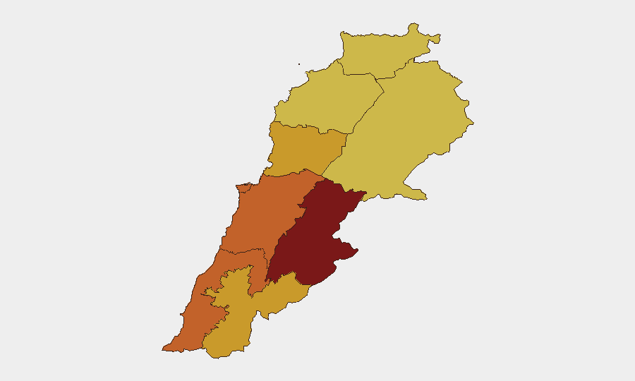
Beqaa and South Governorates dominate the sub-national ranking, with composite risks of 100 and 75.8 respectively, reflecting active Israeli military strikes, Hezbollah positions, and cross-border engagement. Beirut Governorate (74.6) and Mount Lebanon (73.3) follow, indicating that conflict-related risk now extends beyond southern border zones into the capital and adjacent areas. Nabatieh and Keserwan-Jbeil Governorates (72.9 and 71.9) face compounded risk from both military operations and civilian displacement, while northern and eastern regions (Akkar, North, Baalbek-Hermel, each 70+) remain elevated due to reported Hezbollah infrastructure and Israeli targeting.
How GeoBit Would Assist
Security teams should employ AOI Monitoring & Early Warning with persistent watch on South, Beqaa, and Beirut Governorates to detect shifts in strike patterns, evacuation orders, and casualty reports in real time. Battle mapping and force-structure tracking combined with conflict event feeds and OSINT fusion will establish verified casualty figures, Israeli targeting intentions, and Hezbollah response timelines—critical for duty-of-care decisions on personnel movement. Alternative route and network analysis tools enable rapid identification of safer transit corridors as evacuation zones expand northward.
7-Day Outlook
Sustained Israeli military operations and Hezbollah counterattacks indicate no near-term ceasefire prospect; further northward expansion of evacuation zones and strikes into Mount Lebanon and potentially Beirut suburbs remains a material risk. Civilian displacement, medical system strain, and supply-chain disruption will likely intensify, with secondary effects on corporate operations, employee safety, and logistics throughput across Lebanon.
Highest-Risk Areas — Ranked
| # | State / Region | Risk |
|---|---|---|
| 1 | Beqaa Governorate | 100 |
| 2 | South Governorate | 75.8 |
| 3 | Beirut Governorate | 74.6 |
| 4 | Mount Lebanon Governorate | 73.3 |
| 5 | Nabatieh Governorate | 72.9 |
| 6 | Keserwan-Jbeil Governorate | 71.9 |
| 7 | Akkar Governorate | 70.4 |
| 8 | North Governorate | 70 |
| 9 | Baalbek-Hermel Governorate | 70 |
Sources
Previous Daily Briefs
A new Lebanon brief is written every day — each with its own risk map and downloadable CSV. Here's the last week; use the calendar to go further back.
📅 Browse every day by calendar →
Highlighted days have a brief. Tap a day for that day's map & analysis, or “csv” for that day's dataset ($5).