Situation Summary
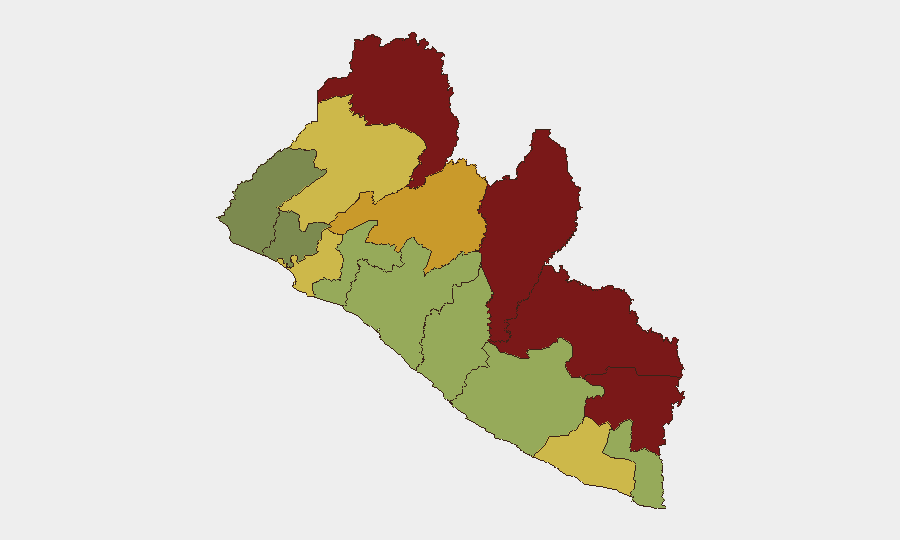
Liberia remains a low-threat environment globally (#141), with no major nationwide security incidents in the current reporting window. However, sub-national risk concentrations in the northeastern counties—particularly Nimba, Lofa, and Grand Gedeh—reflect persistent border volatility, local governance disputes, and underlying resource/criminal activity. Recent incidents along the Guinea border and in River Gee County suggest localized tensions rather than systemic deterioration.
Key Developments
- Sorlumba Border Crossing, Lofa County (Aug. 9–14, 2026): Guinean military personnel crossed into Liberian territory near Foya District, triggering a standoff with Liberian Joint Security forces; Liberia's information minister confirmed the situation was contained and attributed the incident to a checkpoint-location dispute. Forces subsequently de-escalated and the crossing returned to normal operations.
- River Gee County Motorcyclist Clash (Aug. 11–12, 2026): Violent confrontation among motorcyclists in the Gbeapo-Kanweaken area, linked to a leadership dispute within a local motorcyclists' union, resulted in multiple injuries. Police arrested 12 individuals and seized nine motorcycles; county authorities initiated an investigation.
Highest-Risk Areas
Nimba, Lofa, and Grand Gedeh counties (composite scores 92, 88, and 85 respectively) drive the country's sub-national risk profile. Lofa and Grand Gedeh's elevated threat stems from their proximity to Guinea and Sierra Leone borders, where cross-border smuggling, recruitment by armed groups, and periodic military incursions create persistent friction. Nimba's high score reflects both border proximity and internal tensions tied to mining activity, informal militia networks, and weak state presence in remote areas. River Gee, despite ranking fourth, has shown renewed volatility around non-state actor organization (motorcyclist unions) and localized authority disputes.
How GeoBit Would Assist
Organizations with personnel or assets in Liberia's high-risk counties should employ Area-of-Interest (AOI) Monitoring & Early Warning on Nimba, Lofa, and Grand Gedeh to receive alerts on border incidents, inter-communal violence, and armed activity before escalation. Routing & Network Analysis supports duty-of-care teams in planning alternative travel corridors that avoid volatile checkpoints and border zones. Intel Sweep and multi-language OSINT (including Telegram, radio SIGINT, and local radio monitoring) provide real-time situational updates on localized clashes, road blocks, and security force deployments—critical for operations in areas where formal incident reporting is delayed.
7-Day Outlook
No imminent nationwide threat is anticipated. However, the Guinea border remains a flashpoint for periodic incursions and checkpoint disputes, particularly in Lofa; teams operating near Sorlumba and Foya should maintain heightened awareness. River Gee's motorcyclist union dispute is likely to remain localized but may see renewed confrontations if leadership negotiations stall; road travel in that county should proceed with caution and real-time situational verification.
Highest-Risk Areas — Ranked
| # | State / Region | Risk |
|---|---|---|
| 1 | Nimba County | 92 |
| 2 | Lofa County | 88 |
| 3 | Grand Gedeh County | 85 |
| 4 | River Gee County | 83 |
| 5 | Bong County | 72 |
| 6 | Gbarpolu County | 68 |
| 7 | Grand Kru County | 65 |
| 8 | Montserrado County | 64 |
| 9 | Rivercess County | 58 |
| 10 | Sinoe County | 55 |
| 11 | Margibi County | 52 |
| 12 | Grand Bassa County | 48 |
Sources
Previous Daily Briefs
A new Liberia brief is written every day — each with its own risk map and downloadable CSV. Here's the last week; use the calendar to go further back.
- August 16, 2026
- August 14, 2026
- August 12, 2026
- August 10, 2026
- August 8, 2026
- August 6, 2026
- August 5, 2026
📅 Browse every day by calendar →
Highlighted days have a brief. Tap a day for that day's map & analysis, or “csv” for that day's dataset ($5).
Atlas — our AI intelligence desk — emails them this snapshot personally. Nothing else, no list.