Situation Summary
Moldova remains at composite threat level 6 (rank #155 globally) with zero tracked events recorded by GeoBit as of 22 August 2026. However, the country faces persistent airspace violations and drone spillover from the Ukraine conflict, concentrated in border districts and the southern Dniester corridor. Political instability in the autonomous region of Gagauzia, combined with repeated Russian aerial incursions, has sustained elevated operational risk for organizations with personnel or assets in the country, particularly in southern and eastern districts.
Key Developments
- Talmaza, Ștefan Vodă District — 17 August — Moldovan police reported an explosion near the village of Talmaza (approximately 3 km from residential areas) following a drone-related incident; Moldova's Foreign Ministry condemned the airspace violation and assessed it as a direct threat to civilians. [Ștefan Vodă ranks #10 in sub-national risk.]
- Southern Moldovan airspace — 17 August — Ukrainian military and regional sources reported a Russian Banderol cruise missile or strike vehicle transited Moldovan airspace during strikes on Odesa Oblast, with an explosion documented near a Moldovan village.
- Kotlovyna area, northern Moldovan airspace — 20 August, 03:16–03:22 UTC — A Russian Shahed-136 unmanned aerial vehicle entered Moldovan airspace near Kotlovyna, transited toward Etulia, and exited back toward Ukraine within six minutes; confirmed by multiple independent sources.
- Giurgiulești, southern Moldova — 20 August — Two separate drone-related incidents recorded near the Moldova–Ukraine border; Moldova's Ministry of Internal Affairs attributed events to spillover from cross-border military activity in Ukraine.
- Gagauzia autonomous region — 17 August — The regional assembly declared the Bashkan (governor) position vacant following the arrest and conviction of Yevgeniya Hutsul, intensifying internal political fragmentation and reducing institutional coherence in Moldova's easternmost autonomous territory.
- Romanian airspace — 16 August — A Spanish F-18 fighter jet intercepted and shot down an unidentified drone approximately 24 km north of Galați after it crossed from Moldovan territory into Romanian airspace, underscoring the frequency and operational complexity of airspace incidents in the region.
Highest-Risk Areas
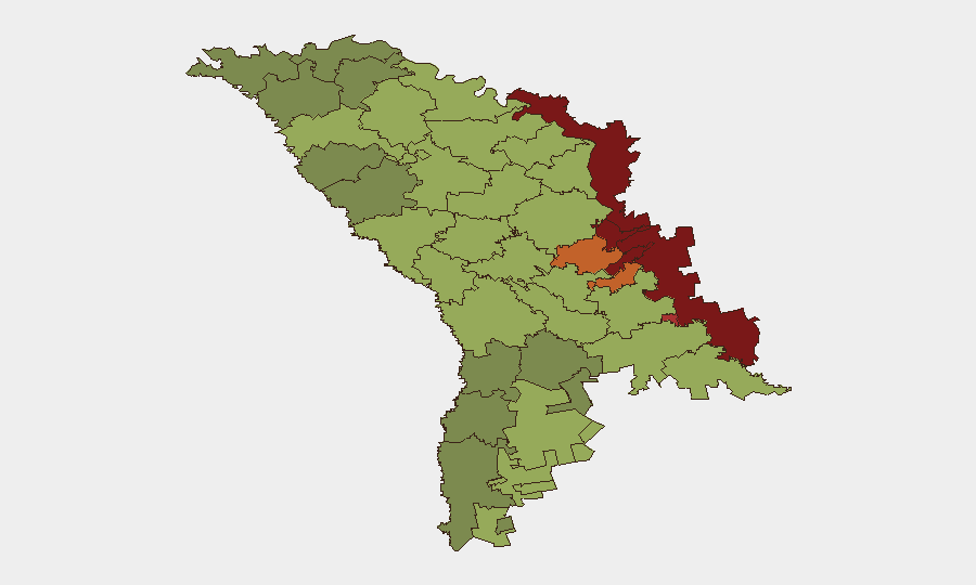
The Left Bank Dniester Administrative-Territorial Units (risk 85) and Dubăsari district (82) remain Moldova's most volatile zones, driven by frozen-conflict dynamics, Russian military presence, and limited Moldovan state control. Bender (79), Criuleni (75), and Rezina (58) face secondary but significant risk from proximity to the Dniester corridor and Ukraine border. Collectively, these districts account for the bulk of airspace violations and drone incidents documented in the last week. Chișinău itself (risk 49) faces lower kinetic threat but elevated political and cyber risk; organizations with regional hubs in the capital should factor political instability and infrastructure resilience into contingency planning.
How GeoBit Would Assist
Organizations operating in Moldova should deploy AOI Monitoring & Early Warning capabilities on southern and eastern border districts to track real-time drone and airspace incidents with sub-6-hour alerting latency. Conflict & Military battle mapping and Aviation tracking tools enable duty officers to correlate Ukrainian and Russian strike patterns with Moldovan airspace crossings and plan movement windows. Routing & Network Analysis can model safe transit corridors and alternative resupply routes that minimize exposure to high-risk zones (particularly Ștefan Vodă, Soroca, and the Dniester belt).
7-Day Outlook
Russian aerial reconnaissance and strike operations targeting Ukraine are expected to sustain repeated, low-intensity airspace violations in Moldovan border districts through late August. Political uncertainty in Gagauzia may trigger localized administrative instability but is unlikely to generate kinetic escalation. Risk trajectory remains stable but volatile; no major shift in threat level is forecast, but the frequency of drone incidents suggests operational planners should assume at least one airspace violation every 24–48 hours in southern Moldova.
Highest-Risk Areas — Ranked
| # | State / Region | Risk |
|---|---|---|
| 1 | Administrative-Territorial Units of the Left Bank of the Dniester | 85 |
| 2 | Dubăsari | 82 |
| 3 | Bender | 79 |
| 4 | Criuleni | 75 |
| 5 | Rezina | 58 |
| 6 | Taraclia | 55 |
| 7 | Gagauzia | 54 |
| 8 | Căușeni | 53 |
| 9 | Soroca | 52 |
| 10 | Ștefan Vodă | 51 |
| 11 | Orhei | 50 |
| 12 | Chișinău | 49 |
Sources
Previous Daily Briefs
A new Moldova brief is written every day — each with its own risk map and downloadable CSV. Here's the last week; use the calendar to go further back.
- August 20, 2026
- August 18, 2026
- August 15, 2026
- August 13, 2026
- August 11, 2026
- August 9, 2026
- August 7, 2026
📅 Browse every day by calendar →
Highlighted days have a brief. Tap a day for that day's map & analysis, or “csv” for that day's dataset ($5).
Atlas — our AI intelligence desk — emails them this snapshot personally. Nothing else, no list.